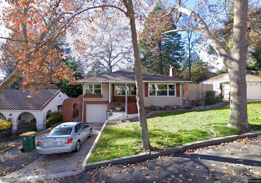
1117 Elm Ave Placerville, CA 95667
Estimated Value: $502,907 - $545,000
4
Beds
2
Baths
2,429
Sq Ft
$217/Sq Ft
Est. Value
About This Home
This home is located at 1117 Elm Ave, Placerville, CA 95667 and is currently estimated at $526,477, approximately $216 per square foot. 1117 Elm Ave is a home located in El Dorado County with nearby schools including El Dorado High School, Country Day Montessori, and El Dorado Adventist School.
Ownership History
Date
Name
Owned For
Owner Type
Purchase Details
Closed on
Oct 11, 2021
Sold by
Davis Ramona M
Bought by
Frenn Michael A and Davis Ramona M
Current Estimated Value
Purchase Details
Closed on
Sep 27, 2001
Sold by
Frenn Michael
Bought by
Davis Ramona M
Home Financials for this Owner
Home Financials are based on the most recent Mortgage that was taken out on this home.
Original Mortgage
$168,000
Outstanding Balance
$65,809
Interest Rate
6.9%
Estimated Equity
$460,668
Purchase Details
Closed on
May 18, 1996
Sold by
Barber Holly K and Barber Coralee H
Bought by
Davis Ramona M
Home Financials for this Owner
Home Financials are based on the most recent Mortgage that was taken out on this home.
Original Mortgage
$123,200
Interest Rate
8.07%
Create a Home Valuation Report for This Property
The Home Valuation Report is an in-depth analysis detailing your home's value as well as a comparison with similar homes in the area
Home Values in the Area
Average Home Value in this Area
Purchase History
| Date | Buyer | Sale Price | Title Company |
|---|---|---|---|
| Frenn Michael A | -- | None Available | |
| Davis Ramona M | -- | Old Republic Title Company | |
| Davis Ramona M | $154,000 | Fidelity National Title |
Source: Public Records
Mortgage History
| Date | Status | Borrower | Loan Amount |
|---|---|---|---|
| Open | Davis Ramona M | $168,000 | |
| Closed | Davis Ramona M | $123,200 |
Source: Public Records
Tax History Compared to Growth
Tax History
| Year | Tax Paid | Tax Assessment Tax Assessment Total Assessment is a certain percentage of the fair market value that is determined by local assessors to be the total taxable value of land and additions on the property. | Land | Improvement |
|---|---|---|---|---|
| 2025 | $2,667 | $255,791 | $49,818 | $205,973 |
| 2024 | $2,667 | $250,777 | $48,842 | $201,935 |
| 2023 | $2,636 | $245,861 | $47,885 | $197,976 |
| 2022 | $2,599 | $241,042 | $46,947 | $194,095 |
| 2021 | $2,570 | $236,317 | $46,027 | $190,290 |
| 2020 | $2,458 | $233,895 | $45,556 | $188,339 |
| 2019 | $2,426 | $229,310 | $44,663 | $184,647 |
| 2018 | $2,352 | $224,815 | $43,788 | $181,027 |
| 2017 | $2,316 | $220,408 | $42,930 | $177,478 |
| 2016 | $2,278 | $216,088 | $42,089 | $173,999 |
| 2015 | $2,172 | $212,844 | $41,457 | $171,387 |
| 2014 | $2,172 | $208,677 | $40,646 | $168,031 |
Source: Public Records
Map
Nearby Homes
- 2896 Clay St
- 2921 Miller Way
- 0 Lincoln Alley
- 0 Trails End Dr Unit 225117516
- 2-Acres Homestead Dr
- 3 Acres
- 678 Main St
- 2977 Mosquito Rd
- 8325 County Rd M44
- 2940 Anderson Way
- 901 Union St
- 3095 Cedar Ravine Rd
- 3022 Constellation Ave
- 1001 Utah Dr
- Plan 2 at Sutter’s Ridge
- 1017 Utah Dr
- 910 Reservoir St
- 3113 Clark St
- 1011 Utah Dr
- 1015 Utah Dr