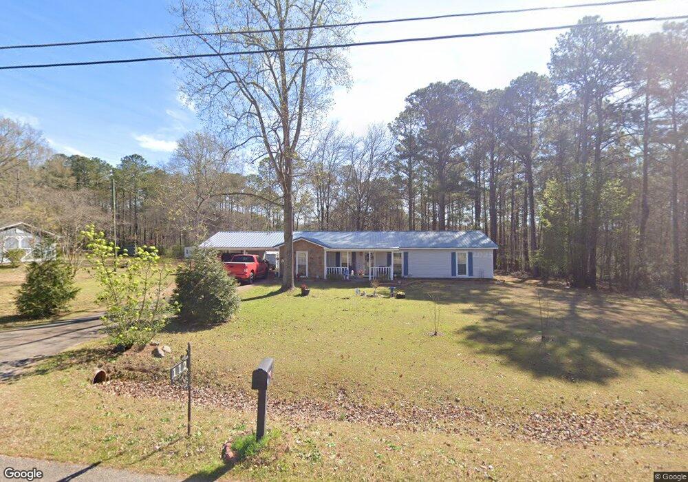
112 N Lake Dr Lagrange, GA 30240
Estimated Value: $191,530 - $233,000
3
Beds
2
Baths
1,459
Sq Ft
$150/Sq Ft
Est. Value
About This Home
This home is located at 112 N Lake Dr, Lagrange, GA 30240 and is currently estimated at $218,633, approximately $149 per square foot. 112 N Lake Dr is a home located in Troup County with nearby schools including Ethel W. Kight Elementary School, Hollis Hand Elementary School, and Franklin Forest Elementary School.
Ownership History
Date
Name
Owned For
Owner Type
Purchase Details
Closed on
Jan 1, 1985
Sold by
Rebecca Roger and Rebecca Levens
Bought by
Hurston Harold Brent
Current Estimated Value
Purchase Details
Closed on
Feb 9, 1979
Sold by
Dan-Ric Inc
Bought by
Rebecca Roger and Rebecca Levens
Purchase Details
Closed on
Mar 31, 1978
Sold by
Mrs Buron Freeman
Bought by
Dan-Ric Inc
Create a Home Valuation Report for This Property
The Home Valuation Report is an in-depth analysis detailing your home's value as well as a comparison with similar homes in the area
Home Values in the Area
Average Home Value in this Area
Purchase History
| Date | Buyer | Sale Price | Title Company |
|---|---|---|---|
| Hurston Harold Brent | $53,200 | -- | |
| Rebecca Roger | $39,900 | -- | |
| Dan-Ric Inc | -- | -- |
Source: Public Records
Tax History Compared to Growth
Tax History
| Year | Tax Paid | Tax Assessment Tax Assessment Total Assessment is a certain percentage of the fair market value that is determined by local assessors to be the total taxable value of land and additions on the property. | Land | Improvement |
|---|---|---|---|---|
| 2024 | -- | $56,504 | $10,000 | $46,504 |
| 2023 | $0 | $57,280 | $10,000 | $47,280 |
| 2022 | $1,526 | $54,680 | $10,000 | $44,680 |
| 2021 | $1,332 | $44,156 | $8,000 | $36,156 |
| 2020 | $1,332 | $44,156 | $8,000 | $36,156 |
| 2019 | $1,049 | $34,796 | $4,000 | $30,796 |
| 2018 | $0 | $31,992 | $4,000 | $27,992 |
| 2017 | $731 | $31,992 | $4,000 | $27,992 |
| 2016 | $703 | $31,044 | $4,000 | $27,044 |
| 2015 | $878 | $31,044 | $4,000 | $27,044 |
| 2014 | $836 | $29,621 | $4,000 | $25,621 |
| 2013 | -- | $31,018 | $4,000 | $27,018 |
Source: Public Records
Map
Nearby Homes
- 709 Vernon Ferry Rd
- 0 Deming St Unit 10550189
- 103 Dogwood Ct
- 104 Dogwood Point
- 226 Linda Ln
- 4004 White Oak Ln
- LOT 4 Angela Dr
- E Angela Dr
- 135 Planters Ridge Dr
- 124 Foxdale Dr
- 200 Cheyenne Dr
- 190 Hill Rd
- 243 Oak Dr
- 102 Foxdale Dr
- 208 Highland Trail
- 146 Whitaker Rd
- 104 Spring Valley Dr
- 108 Spring Valley Dr
- 641 Whitaker Rd
- 0 Antioch Rd Unit 10656005
- 98 N Lake Dr
- 114 N Lake Dr Unit 34
- 114 N Lake Dr
- 107 N Lake Dr
- 109 N Lake Dr
- 664 Vernon Ferry Rd
- 646 Vernon Ferry Rd
- 105 N Lake Dr
- 111 N Lake Dr
- 501 Riverside Dr
- 636 Vernon Ferry Rd
- 118 N Lake Dr
- 626 Vernon Ferry Rd
- 113 N Lake Dr
- 704 Vernon Ferry Rd
- 115 N Lake Dr
- 102 Riverside Ct Unit 77 78 79
- 102 Riverside Ct Unit 77-79
- 669 Vernon Ferry Rd
- 120 N Lake Dr