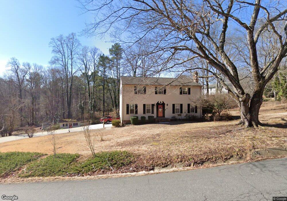
11200 Surry Rd Chester, VA 23831
Estimated Value: $403,000 - $451,000
4
Beds
3
Baths
3,080
Sq Ft
$139/Sq Ft
Est. Value
About This Home
This home is located at 11200 Surry Rd, Chester, VA 23831 and is currently estimated at $429,190, approximately $139 per square foot. 11200 Surry Rd is a home located in Chesterfield County with nearby schools including C E Curtis Elementary School, Bellwood Elementary School, and Elizabeth Davis Middle School.
Ownership History
Date
Name
Owned For
Owner Type
Purchase Details
Closed on
Jun 15, 2018
Sold by
Surratt Gary H and Surratt Anita D
Bought by
Corum William L and Corum Kandi S
Current Estimated Value
Home Financials for this Owner
Home Financials are based on the most recent Mortgage that was taken out on this home.
Original Mortgage
$258,236
Outstanding Balance
$223,331
Interest Rate
4.5%
Mortgage Type
FHA
Estimated Equity
$205,859
Create a Home Valuation Report for This Property
The Home Valuation Report is an in-depth analysis detailing your home's value as well as a comparison with similar homes in the area
Home Values in the Area
Average Home Value in this Area
Purchase History
| Date | Buyer | Sale Price | Title Company |
|---|---|---|---|
| Corum William L | $263,000 | First Title & Escrow Inc |
Source: Public Records
Mortgage History
| Date | Status | Borrower | Loan Amount |
|---|---|---|---|
| Open | Corum William L | $258,236 |
Source: Public Records
Tax History Compared to Growth
Tax History
| Year | Tax Paid | Tax Assessment Tax Assessment Total Assessment is a certain percentage of the fair market value that is determined by local assessors to be the total taxable value of land and additions on the property. | Land | Improvement |
|---|---|---|---|---|
| 2025 | $3,791 | $423,100 | $63,500 | $359,600 |
| 2024 | $3,791 | $412,500 | $61,500 | $351,000 |
| 2023 | $3,328 | $365,700 | $55,500 | $310,200 |
| 2022 | $3,325 | $361,400 | $51,500 | $309,900 |
| 2021 | $2,817 | $289,600 | $47,500 | $242,100 |
| 2020 | $2,751 | $289,600 | $47,500 | $242,100 |
| 2019 | $2,672 | $281,300 | $47,500 | $233,800 |
| 2018 | $2,373 | $250,400 | $47,500 | $202,900 |
| 2017 | $2,317 | $236,100 | $47,500 | $188,600 |
| 2016 | $2,267 | $236,100 | $47,500 | $188,600 |
| 2015 | $2,226 | $229,300 | $47,500 | $181,800 |
| 2014 | $2,178 | $224,300 | $47,500 | $176,800 |
Source: Public Records
Map
Nearby Homes
- Lot 7 Surry Place
- 10920 Stepney Rd
- 11600 Hillside Rd
- 11360 Elokomin Ave
- 11749 Cliff Lawn Dr
- 3512 Castlebury Dr
- 11306 Elokomin Ave
- 10513 Surry Rd
- 11800 Shady Ln
- 11816 Shady Ln
- 11709 Boyd Rd
- 2716 Goyne Loop
- 11016 Timonium Dr
- 10906 Timonium Dr
- 3230 Perdue Springs Ln
- 3000 Perdue Springs Ln
- 12137 Perdue Springs Loop
- 12173 Calgary Loop
- 12136 Warfield Estates Dr
- 3713 Yantis Ct
- 2901 Surry Ct
- 2831 Deford Ct
- 11121 Surry Rd
- 2911 Surry Ct
- 2830 Deford Ct
- 11111 Surry Rd
- 2821 Deford Ct
- 2900 Surry Ct
- 11111 Surry Rd
- 2800 Woodland Rd
- 11300 Surry Rd
- 11103 Surry Rd
- 2910 Surry Ct
- 2811 Deford Ct
- 11101 Surry Place
- 2811 Woodland Rd
- 2814 Deford Ct
- 11400 Rolling Brook Rd
- 3001 Castlebury Dr
- 11310 Surry Rd