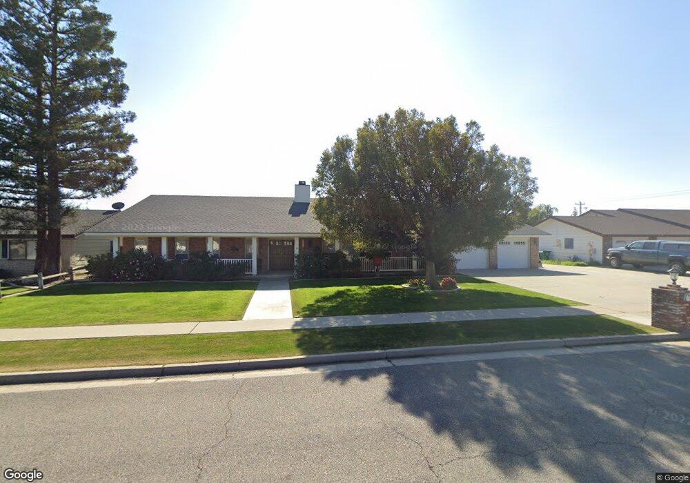
11209 Dee Dee Ct Bakersfield, CA 93312
Polo Grounds NeighborhoodEstimated Value: $608,000 - $726,000
3
Beds
3
Baths
3,516
Sq Ft
$189/Sq Ft
Est. Value
About This Home
This home is located at 11209 Dee Dee Ct, Bakersfield, CA 93312 and is currently estimated at $665,674, approximately $189 per square foot. 11209 Dee Dee Ct is a home located in Kern County with nearby schools including Rosedale-North Elementary School, Freedom Middle School, and Centennial High School.
Ownership History
Date
Name
Owned For
Owner Type
Purchase Details
Closed on
Feb 12, 2007
Sold by
Buckles Roger K and The Everett & Mamie Buckles Fa
Bought by
Rice Ray C and Rice Willa Mae
Current Estimated Value
Home Financials for this Owner
Home Financials are based on the most recent Mortgage that was taken out on this home.
Original Mortgage
$225,000
Outstanding Balance
$135,139
Interest Rate
6.21%
Mortgage Type
New Conventional
Estimated Equity
$530,535
Purchase Details
Closed on
Mar 22, 2005
Sold by
Buckles Everett R and Buckles Mamie L
Bought by
Buckles Roger K and The Everett & Mamie Buckles Fa
Purchase Details
Closed on
Jun 15, 2001
Sold by
Buckles Everett R and Buckles Mamie L
Bought by
Buckles Everett R and Buckles Mamie L
Create a Home Valuation Report for This Property
The Home Valuation Report is an in-depth analysis detailing your home's value as well as a comparison with similar homes in the area
Home Values in the Area
Average Home Value in this Area
Purchase History
| Date | Buyer | Sale Price | Title Company |
|---|---|---|---|
| Rice Ray C | $425,000 | Ticor Title Company Of Ca | |
| Buckles Roger K | -- | -- | |
| Buckles Everett R | -- | -- |
Source: Public Records
Mortgage History
| Date | Status | Borrower | Loan Amount |
|---|---|---|---|
| Open | Rice Ray C | $225,000 |
Source: Public Records
Tax History
| Year | Tax Paid | Tax Assessment Tax Assessment Total Assessment is a certain percentage of the fair market value that is determined by local assessors to be the total taxable value of land and additions on the property. | Land | Improvement |
|---|---|---|---|---|
| 2025 | $6,887 | $569,396 | $194,263 | $375,133 |
| 2024 | $6,749 | $558,232 | $190,454 | $367,778 |
| 2023 | $6,749 | $547,287 | $186,720 | $360,567 |
| 2022 | $5,706 | $457,000 | $114,000 | $343,000 |
| 2021 | $5,422 | $436,000 | $109,000 | $327,000 |
| 2020 | $4,809 | $386,000 | $97,000 | $289,000 |
| 2019 | $4,766 | $381,000 | $86,000 | $295,000 |
| 2018 | $4,852 | $394,000 | $99,000 | $295,000 |
| 2017 | $4,964 | $400,000 | $100,000 | $300,000 |
| 2016 | $3,875 | $326,000 | $82,000 | $244,000 |
| 2015 | $4,937 | $422,000 | $106,000 | $316,000 |
| 2014 | $5,119 | $440,000 | $110,000 | $330,000 |
Source: Public Records
Map
Nearby Homes
- 3301 Beyers St
- 1900 Jewetta Ave
- 3105 Silver Spur Way
- 11705 Cactus Dr
- 3122 Campfire Dr Unit 2
- 3416 Aslin St
- 3435 Moss St
- 10512 Dee Ave
- 10701 Meacham Rd
- 3604 Mehgan Ave
- 11908 Nebula Ct
- 11910 Compass Ave
- 3622 Azure Dr
- 3100 Woodstown St
- 2125 Verdugo Ln
- 11265 Poulsen Way
- 3603 Deslok Dr
- 2008 Torrey Dr
- 10601 Michele Ave
- 10409 Lonon Ave
- 11209 Dee Ct
- 11217 Dee Ct
- 11201 Dee Ct
- 11217 Dee Dee Ct
- 11201 Dee Dee Ct
- 11117 Dee Dee Ct
- 11208 Aimee Way
- 11208 Dee Dee Ct
- 11208 Dee Ct
- 11216 Aimee Way
- 11200 Dee Ct
- 11200 Aimee Way
- 11200 Dee Dee Ct
- 11216 Dee Ct
- 11216 Dee Dee Ct
- 11116 Dee Dee Ct
- 11116 Aimee Way
- 3201 Jewetta Ave
- 11109 Dee Dee Ct
- 11108 Dee Dee Ct
Your Personal Tour Guide
Ask me questions while you tour the home.