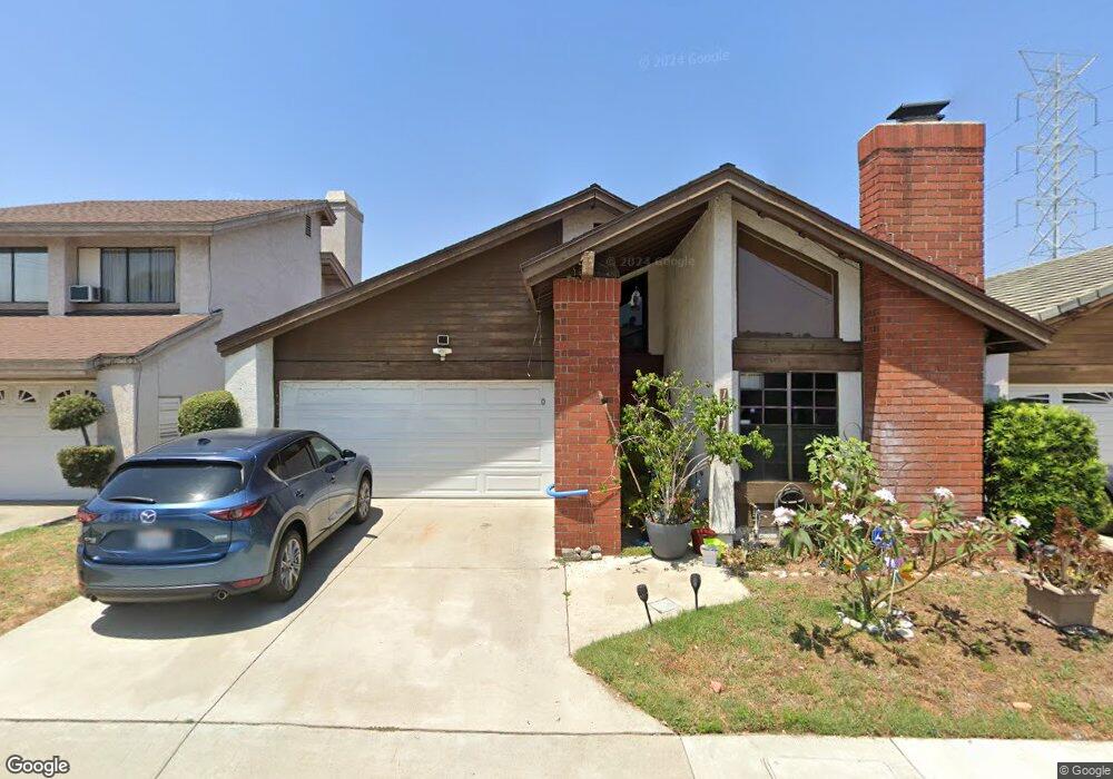
1121 S Bender Ave Glendora, CA 91740
Charter oak NeighborhoodEstimated Value: $678,866 - $840,000
3
Beds
2
Baths
1,380
Sq Ft
$544/Sq Ft
Est. Value
About This Home
This home is located at 1121 S Bender Ave, Glendora, CA 91740 and is currently estimated at $750,717, approximately $543 per square foot. 1121 S Bender Ave is a home located in Los Angeles County with nearby schools including Washington Elementary School, Royal Oak Middle School, and Charter Oak High School.
Ownership History
Date
Name
Owned For
Owner Type
Purchase Details
Closed on
Apr 21, 2023
Sold by
Coy Sylvia and Coy Steven J
Bought by
Coy Trust
Current Estimated Value
Purchase Details
Closed on
Aug 9, 1994
Sold by
Olmos Sylvia
Bought by
Coy Steven J
Home Financials for this Owner
Home Financials are based on the most recent Mortgage that was taken out on this home.
Original Mortgage
$138,000
Interest Rate
8.51%
Create a Home Valuation Report for This Property
The Home Valuation Report is an in-depth analysis detailing your home's value as well as a comparison with similar homes in the area
Home Values in the Area
Average Home Value in this Area
Purchase History
| Date | Buyer | Sale Price | Title Company |
|---|---|---|---|
| Coy Trust | -- | None Listed On Document | |
| Coy Steven J | -- | Chicago Title Insurance Co |
Source: Public Records
Mortgage History
| Date | Status | Borrower | Loan Amount |
|---|---|---|---|
| Previous Owner | Coy Steven J | $138,000 |
Source: Public Records
Tax History
| Year | Tax Paid | Tax Assessment Tax Assessment Total Assessment is a certain percentage of the fair market value that is determined by local assessors to be the total taxable value of land and additions on the property. | Land | Improvement |
|---|---|---|---|---|
| 2025 | $4,141 | $331,127 | $91,969 | $239,158 |
| 2024 | $4,141 | $324,635 | $90,166 | $234,469 |
| 2023 | $4,043 | $318,271 | $88,399 | $229,872 |
| 2022 | $3,991 | $312,031 | $86,666 | $225,365 |
| 2021 | $3,929 | $305,914 | $84,967 | $220,947 |
| 2019 | $3,844 | $296,843 | $82,448 | $214,395 |
| 2018 | $3,643 | $291,024 | $80,832 | $210,192 |
| 2016 | $3,478 | $279,726 | $77,695 | $202,031 |
| 2015 | $3,464 | $275,525 | $76,528 | $198,997 |
| 2014 | $3,461 | $270,128 | $75,029 | $195,099 |
Source: Public Records
Map
Nearby Homes
- 605 W Gaillard St
- 1039 Brightview Dr
- 119 W Gladstone St
- 205 W Linfield St
- 1356 S Prospero Dr
- 839 Alford St
- 6003 N Briargate Ln
- 732 W Bagnall St
- 18824 E Armstead St
- 5724 N Galanto Ave
- 1700 S Glendora Ave Unit 43
- 315 E Juanita Ave
- 5505 N Traymore Ave
- 1630 S Barranca Ave
- 1630 S Barranca Ave Unit 173
- 1630 S Barranca Ave Unit 126
- 19003 E Haltern Ave
- 1760 S Vecino Ave
- 201 E Arrow Hwy Unit 64
- 201 E Arrow Hwy Unit 70
- 1117 S Bender Ave
- 1125 S Bender Ave
- 1122 S Westridge Ave
- 1113 S Bender Ave
- 1124 S Bender Ave
- 1118 S Bender Ave
- 1118 S Westridge Ave
- 1109 S Bender Ave
- 1105 S Bender Ave
- 1116 S Westridge Ave
- 1201 S Bender Ave
- 343 W Dawson Ct
- 1200 S Bender Ave
- 1123 S Westridge Ave
- 1115 S Westridge Ave
- 1211 S Bender Ave
- 335 W Dawson Ct
- 409 W Dawson Ave
- 1210 S Bender Ave
- 400 W Dawson Ave
Your Personal Tour Guide
Ask me questions while you tour the home.