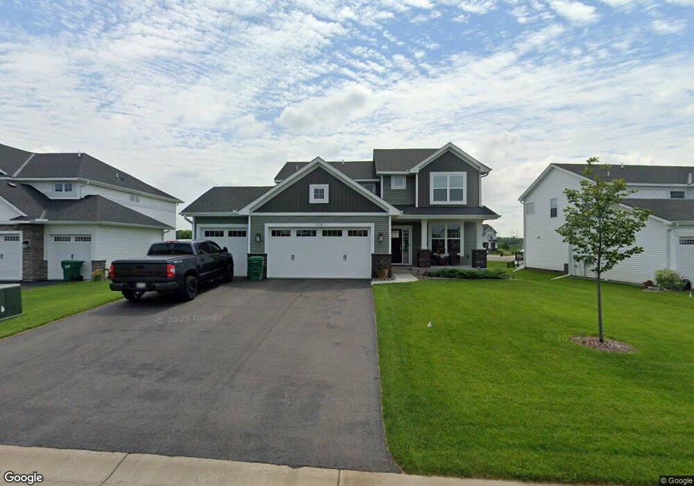
11212 Creekside Trail Maple Grove, MN 55311
Estimated Value: $569,753 - $616,000
4
Beds
3
Baths
2,264
Sq Ft
$260/Sq Ft
Est. Value
About This Home
This home is located at 11212 Creekside Trail, Maple Grove, MN 55311 and is currently estimated at $589,438, approximately $260 per square foot. 11212 Creekside Trail is a home with nearby schools including Fernbrook Elementary School, Osseo Middle School, and Maple Grove Senior High School.
Ownership History
Date
Name
Owned For
Owner Type
Purchase Details
Closed on
Sep 20, 2022
Sold by
Us Home Llc
Bought by
Chandee Toon and Chandee Peng
Current Estimated Value
Home Financials for this Owner
Home Financials are based on the most recent Mortgage that was taken out on this home.
Original Mortgage
$100,000
Outstanding Balance
$95,336
Interest Rate
4.99%
Mortgage Type
New Conventional
Estimated Equity
$494,102
Purchase Details
Closed on
Sep 15, 2022
Sold by
Us Home Llc
Bought by
Chandee Toon and Chandee Peng
Home Financials for this Owner
Home Financials are based on the most recent Mortgage that was taken out on this home.
Original Mortgage
$100,000
Outstanding Balance
$95,336
Interest Rate
4.99%
Mortgage Type
New Conventional
Estimated Equity
$494,102
Create a Home Valuation Report for This Property
The Home Valuation Report is an in-depth analysis detailing your home's value as well as a comparison with similar homes in the area
Home Values in the Area
Average Home Value in this Area
Purchase History
| Date | Buyer | Sale Price | Title Company |
|---|---|---|---|
| Chandee Toon | $526,705 | -- | |
| Chandee Toon | $526,705 | None Listed On Document |
Source: Public Records
Mortgage History
| Date | Status | Borrower | Loan Amount |
|---|---|---|---|
| Open | Chandee Toon | $100,000 | |
| Closed | Chandee Toon | $100,000 |
Source: Public Records
Tax History Compared to Growth
Tax History
| Year | Tax Paid | Tax Assessment Tax Assessment Total Assessment is a certain percentage of the fair market value that is determined by local assessors to be the total taxable value of land and additions on the property. | Land | Improvement |
|---|---|---|---|---|
| 2024 | $6,848 | $522,300 | $130,000 | $392,300 |
| 2023 | $6,057 | $485,800 | $100,000 | $385,800 |
| 2022 | $373 | $102,000 | $65,000 | $37,000 |
| 2021 | $0 | $0 | $0 | $0 |
Source: Public Records
Map
Nearby Homes
- 19537 Millpond Way
- 11500 Brookview Dr
- 11460 Grassland Way
- XXX Brockton Ln N
- 19690 116th Ave N
- 11633 Minnesota Ln N
- Aspen Plan at Evanswood
- Gibson Plan at Evanswood
- Kenton Plan at Evanswood
- Sutherland Plan at Evanswood
- Augustine Plan at Evanswood
- Kendall Plan at Evanswood
- Middleton Plan at Evanswood
- Riley Plan at Evanswood
- Victoria Plan at Evanswood
- 19590 105th Ave
- 19554 105th Ave
- 19602 105th Ave
- 19638 105th Ave
- 19614 105th Ave
- 11200 Creekside Trail
- 19162 Blue Stem Ct
- 11226 Creekside Trail
- 11188 Creekside Trail
- 19212 Sweet Bay Ct
- 11234 Creekside Trail
- 19255 Sweet Bay Ct
- 19150 Blue Stem Ct
- 19226 Sweet Bay Ct
- 19250 Blue Stem Ct
- 19255 Sweet Bay Ct
- 11244 Creekside Trail
- 19201 Blue Stem Ct
- 19165 Blue Stem Ct
- 19263 Sweet Bay Ct
- 19221 Blue Stem Ct
- 19145 Blue Stem Ct
- 19181 Blue Stem Ct
- 11250 Creekside Trail
- 19241 Blue Stem Ct