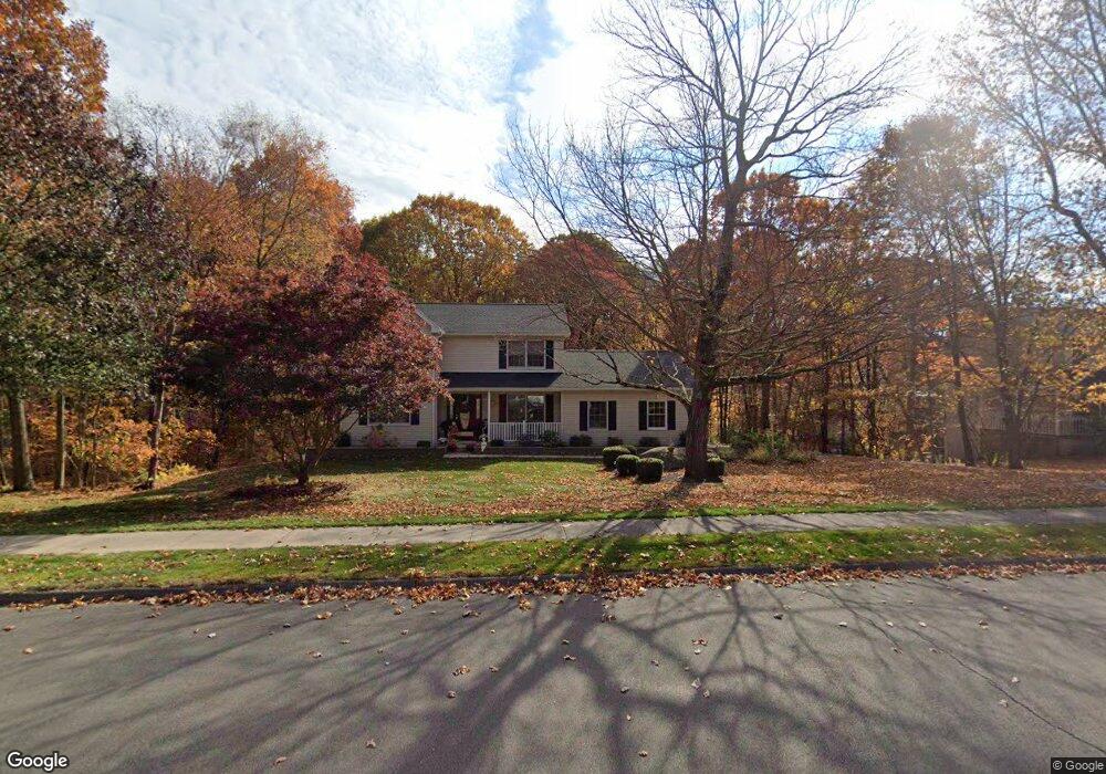
113 Brandon Run Bristol, CT 06010
South Bristol NeighborhoodEstimated Value: $476,000 - $509,000
3
Beds
3
Baths
1,744
Sq Ft
$280/Sq Ft
Est. Value
About This Home
This home is located at 113 Brandon Run, Bristol, CT 06010 and is currently estimated at $488,738, approximately $280 per square foot. 113 Brandon Run is a home located in Hartford County with nearby schools including Chippens Hill Middle School, Bristol Central High School, and Immanuel Lutheran School.
Ownership History
Date
Name
Owned For
Owner Type
Purchase Details
Closed on
May 4, 2007
Sold by
Rigsby Michael P and Rigsby Silvia A
Bought by
Silva Antonio A and Silva Maria L
Current Estimated Value
Home Financials for this Owner
Home Financials are based on the most recent Mortgage that was taken out on this home.
Original Mortgage
$200,000
Interest Rate
6.23%
Purchase Details
Closed on
May 12, 1994
Sold by
Rockwood Developers
Bought by
Rigsby Michael P and Alfonso Silvia A
Create a Home Valuation Report for This Property
The Home Valuation Report is an in-depth analysis detailing your home's value as well as a comparison with similar homes in the area
Home Values in the Area
Average Home Value in this Area
Purchase History
| Date | Buyer | Sale Price | Title Company |
|---|---|---|---|
| Silva Antonio A | $350,000 | -- | |
| Rigsby Michael P | $157,000 | -- |
Source: Public Records
Mortgage History
| Date | Status | Borrower | Loan Amount |
|---|---|---|---|
| Closed | Rigsby Michael P | $145,350 | |
| Closed | Rigsby Michael P | $179,067 | |
| Closed | Rigsby Michael P | $200,000 | |
| Previous Owner | Rigsby Michael P | $113,000 |
Source: Public Records
Tax History Compared to Growth
Tax History
| Year | Tax Paid | Tax Assessment Tax Assessment Total Assessment is a certain percentage of the fair market value that is determined by local assessors to be the total taxable value of land and additions on the property. | Land | Improvement |
|---|---|---|---|---|
| 2025 | $8,108 | $240,240 | $56,070 | $184,170 |
| 2024 | $7,652 | $240,240 | $56,070 | $184,170 |
| 2023 | $7,291 | $240,240 | $56,070 | $184,170 |
| 2022 | $6,918 | $180,390 | $43,260 | $137,130 |
| 2021 | $6,918 | $180,390 | $43,260 | $137,130 |
| 2020 | $6,918 | $180,390 | $43,260 | $137,130 |
| 2019 | $6,864 | $180,390 | $43,260 | $137,130 |
| 2018 | $6,653 | $180,390 | $43,260 | $137,130 |
| 2017 | $6,547 | $181,720 | $61,740 | $119,980 |
| 2016 | $6,547 | $181,720 | $61,740 | $119,980 |
| 2015 | $6,289 | $181,720 | $61,740 | $119,980 |
| 2014 | $6,289 | $181,720 | $61,740 | $119,980 |
Source: Public Records
Map
Nearby Homes
- 101 Corbin Ridge
- 140 Corbin Ridge
- 123 Corbin Ridge
- 13 Overlook Terrace
- 22 Overlook Terrace
- 32 Cameron Dr
- 351 Witches Rock Rd
- 145 Corbin Ridge
- 93-95 Eastview Rd
- 156 Corbin Ridge
- 115 Kilmartin Ave
- 4 Fall Mountain Terrace
- 26 Kilmartin Ave
- 27 Club Ln
- 41 Fall Mountain Lake Rd
- 1253 Spindle Hill Rd
- 174 Town Line Rd
- 48 Cancellaro Dr
- 66 Mattatuck Rd
- 1166 Spindle Hill Rd