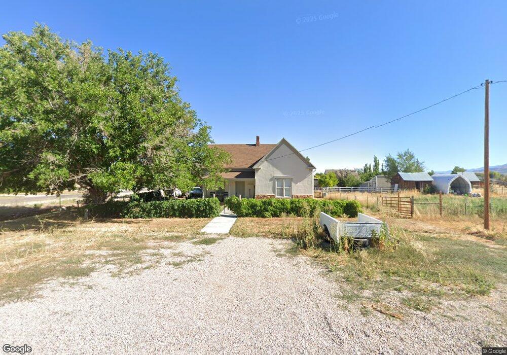
113 E Center St Kanosh, UT 84637
Estimated Value: $216,350 - $414,000
2
Beds
1
Bath
1,230
Sq Ft
$241/Sq Ft
Est. Value
About This Home
This home is located at 113 E Center St, Kanosh, UT 84637 and is currently estimated at $296,338, approximately $240 per square foot. 113 E Center St is a home located in Millard County.
Ownership History
Date
Name
Owned For
Owner Type
Purchase Details
Closed on
Dec 4, 2023
Sold by
Paradise Resources Lc
Bought by
Paradise Farm Land Llc
Current Estimated Value
Purchase Details
Closed on
Jul 12, 2018
Sold by
Smart Kevin A
Bought by
Cannon James D
Home Financials for this Owner
Home Financials are based on the most recent Mortgage that was taken out on this home.
Original Mortgage
$87,875
Interest Rate
4.6%
Mortgage Type
New Conventional
Purchase Details
Closed on
Jul 2, 2018
Sold by
Maxart Stave
Bought by
Smart Kevin A
Home Financials for this Owner
Home Financials are based on the most recent Mortgage that was taken out on this home.
Original Mortgage
$87,875
Interest Rate
4.6%
Mortgage Type
New Conventional
Purchase Details
Closed on
Dec 20, 2017
Sold by
Smart Kevin A
Bought by
Maxfield Steve and Maxart Family Trust
Purchase Details
Closed on
Apr 8, 2008
Sold by
Laphel Ivin Laphel Ivin
Bought by
Smart Kevin A
Create a Home Valuation Report for This Property
The Home Valuation Report is an in-depth analysis detailing your home's value as well as a comparison with similar homes in the area
Purchase History
| Date | Buyer | Sale Price | Title Company |
|---|---|---|---|
| Paradise Farm Land Llc | -- | None Listed On Document | |
| Cannon James D | -- | -- | |
| Smart Kevin A | -- | Meridian Title | |
| Maxfield Steve | -- | -- | |
| Smart Kevin A | -- | Metro National Title |
Source: Public Records
Mortgage History
| Date | Status | Borrower | Loan Amount |
|---|---|---|---|
| Previous Owner | Smart Kevin A | $87,875 |
Source: Public Records
Tax History
| Year | Tax Paid | Tax Assessment Tax Assessment Total Assessment is a certain percentage of the fair market value that is determined by local assessors to be the total taxable value of land and additions on the property. | Land | Improvement |
|---|---|---|---|---|
| 2025 | $809 | $105,967 | $29,849 | $76,118 |
| 2024 | $809 | $101,344 | $15,642 | $85,702 |
| 2023 | $991 | $101,344 | $15,642 | $85,702 |
| 2022 | $609 | $57,233 | $12,514 | $44,719 |
| 2021 | $1,073 | $97,225 | $19,784 | $77,441 |
| 2020 | $933 | $85,365 | $17,985 | $67,380 |
| 2019 | $842 | $77,477 | $16,500 | $60,977 |
| 2018 | $620 | $58,458 | $12,600 | $45,858 |
| 2017 | $648 | $58,458 | $12,600 | $45,858 |
| 2016 | $416 | $39,122 | $11,250 | $27,872 |
| 2015 | $416 | $39,122 | $11,250 | $27,872 |
| 2014 | -- | $39,122 | $11,250 | $27,872 |
| 2013 | -- | $39,122 | $11,250 | $27,872 |
Source: Public Records
Map
Nearby Homes
- 135 E 200 N
- 115 W 200 S
- 58 E 300 South St
- 0 County Road 4616
- Parcel # 8816
- 145 N 200 E
- 80 W 470 N
- 50 N 100 Rd E
- 479 E 100 N
- 1565 W Sunflower Ln Unit 3
- 1615 W Sunflower Ln
- 1615 W Sunflower Ln Unit 4
- 1565 W Sunflower Ln
- 2000 N West Frontage I-15
- 0 Tbd Black Rock Rd Unit LotWP001
- 1100 S 725 Rd W
- 310 S 500 West Rd
- 465 S 100 W
- 760 E 700 St S
- 155 E 500 St S
Your Personal Tour Guide
Ask me questions while you tour the home.