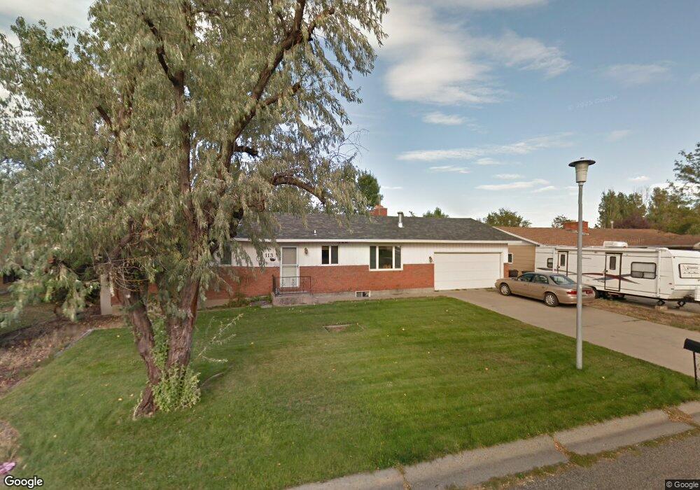
113 Norris Ct N Billings, MT 59105
Billings Heights NeighborhoodEstimated Value: $351,772 - $398,000
3
Beds
2
Baths
1,344
Sq Ft
$279/Sq Ft
Est. Value
About This Home
This home is located at 113 Norris Ct N, Billings, MT 59105 and is currently estimated at $374,443, approximately $278 per square foot. 113 Norris Ct N is a home located in Yellowstone County with nearby schools including Eagle Cliffs Elementary School, Castle Rock Junior High School, and Skyview High School.
Ownership History
Date
Name
Owned For
Owner Type
Purchase Details
Closed on
Dec 6, 2019
Sold by
Jones Richard G
Bought by
Jones Robert M
Current Estimated Value
Home Financials for this Owner
Home Financials are based on the most recent Mortgage that was taken out on this home.
Original Mortgage
$130,000
Outstanding Balance
$115,422
Interest Rate
3.6%
Mortgage Type
New Conventional
Estimated Equity
$259,021
Create a Home Valuation Report for This Property
The Home Valuation Report is an in-depth analysis detailing your home's value as well as a comparison with similar homes in the area
Home Values in the Area
Average Home Value in this Area
Purchase History
| Date | Buyer | Sale Price | Title Company |
|---|---|---|---|
| Jones Robert M | -- | First American Title |
Source: Public Records
Mortgage History
| Date | Status | Borrower | Loan Amount |
|---|---|---|---|
| Open | Jones Robert M | $130,000 |
Source: Public Records
Tax History Compared to Growth
Tax History
| Year | Tax Paid | Tax Assessment Tax Assessment Total Assessment is a certain percentage of the fair market value that is determined by local assessors to be the total taxable value of land and additions on the property. | Land | Improvement |
|---|---|---|---|---|
| 2025 | $3,425 | $356,000 | $64,587 | $291,413 |
| 2024 | $3,425 | $336,000 | $65,171 | $270,829 |
| 2023 | $3,436 | $336,000 | $65,171 | $270,829 |
| 2022 | $2,707 | $227,600 | $54,397 | $173,203 |
| 2021 | $2,572 | $227,600 | $0 | $0 |
| 2020 | $2,695 | $229,800 | $0 | $0 |
| 2019 | $2,535 | $225,200 | $0 | $0 |
| 2018 | $2,454 | $213,300 | $0 | $0 |
| 2017 | $2,391 | $213,300 | $0 | $0 |
| 2016 | $2,194 | $196,100 | $0 | $0 |
| 2015 | $2,148 | $196,100 | $0 | $0 |
| 2014 | $1,924 | $92,220 | $0 | $0 |
Source: Public Records
Map
Nearby Homes
- 1029 Nutter Blvd
- 69 Nugget Place
- 153 W Hilltop Rd
- 320 Stewart Ct N
- 324 Stewart Ct N
- TBD Antelope Place
- 844 Governors Blvd
- 218 Reda Ln Unit 4
- 218 Reda Ln Unit 3
- 225 Windsor Cir N
- 1322 Babcock Cir
- 1017 Toole Cir
- 228 Nash Ln
- 325 Sahara Dr
- 1410 Twin Oaks Dr
- 961 Governors Blvd
- 277 Westchester Square S
- 1422 Watson Peak Rd
- 385 Prospectors Ln
- 2011 Gleneagles Blvd
- 119 Norris Ct N
- 109 Norris Ct N
- 1010 Nutter Blvd
- 1014 Nutter Blvd
- 123 Norris Ct N
- 198 Norris Ct E
- 105 Norris Ct N
- 1018 Nutter Blvd
- 1006 Nutter Blvd
- 116 Norris Ct N
- 199 Norris Ct E
- 122 Norris Ct N
- 1022 Nutter Blvd
- 127 Norris Ct N
- 101 Norris Ct N
- 192 Norris Ct E
- 195 Norris Ct E
- 180 Norris Ct S
- 126 Norris Ct N
- 1026 Nutter Blvd