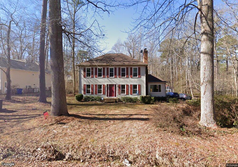
11300 Surry Rd Chester, VA 23831
Estimated Value: $368,000 - $408,547
4
Beds
3
Baths
2,082
Sq Ft
$190/Sq Ft
Est. Value
About This Home
This home is located at 11300 Surry Rd, Chester, VA 23831 and is currently estimated at $395,637, approximately $190 per square foot. 11300 Surry Rd is a home located in Chesterfield County with nearby schools including C E Curtis Elementary School, Bellwood Elementary School, and Elizabeth Davis Middle School.
Ownership History
Date
Name
Owned For
Owner Type
Purchase Details
Closed on
Oct 26, 2001
Sold by
Denlinger Timothy J
Bought by
Lewis David R and Lewis Brenda R
Current Estimated Value
Purchase Details
Closed on
Sep 22, 2000
Sold by
Bartlett Samuel B
Bought by
Denlinger Keri D and Hulbert Stanley S
Home Financials for this Owner
Home Financials are based on the most recent Mortgage that was taken out on this home.
Original Mortgage
$121,633
Interest Rate
8%
Mortgage Type
New Conventional
Create a Home Valuation Report for This Property
The Home Valuation Report is an in-depth analysis detailing your home's value as well as a comparison with similar homes in the area
Home Values in the Area
Average Home Value in this Area
Purchase History
| Date | Buyer | Sale Price | Title Company |
|---|---|---|---|
| Lewis David R | $139,000 | -- | |
| Denlinger Keri D | $124,000 | -- |
Source: Public Records
Mortgage History
| Date | Status | Borrower | Loan Amount |
|---|---|---|---|
| Previous Owner | Denlinger Keri D | $121,633 |
Source: Public Records
Tax History Compared to Growth
Tax History
| Year | Tax Paid | Tax Assessment Tax Assessment Total Assessment is a certain percentage of the fair market value that is determined by local assessors to be the total taxable value of land and additions on the property. | Land | Improvement |
|---|---|---|---|---|
| 2025 | $3,201 | $356,800 | $62,000 | $294,800 |
| 2024 | $3,201 | $349,900 | $60,000 | $289,900 |
| 2023 | $2,842 | $312,300 | $54,000 | $258,300 |
| 2022 | $2,835 | $308,100 | $50,000 | $258,100 |
| 2021 | $2,443 | $250,200 | $46,000 | $204,200 |
| 2020 | $2,377 | $250,200 | $46,000 | $204,200 |
| 2019 | $2,287 | $240,700 | $46,000 | $194,700 |
| 2018 | $2,133 | $224,500 | $46,000 | $178,500 |
| 2017 | $2,033 | $211,800 | $46,000 | $165,800 |
| 2016 | $2,033 | $211,800 | $46,000 | $165,800 |
| 2015 | $1,982 | $203,900 | $46,000 | $157,900 |
| 2014 | $1,957 | $201,300 | $46,000 | $155,300 |
Source: Public Records
Map
Nearby Homes
- Lot 7 Surry Place
- 11600 Hillside Rd
- 10920 Stepney Rd
- 11360 Elokomin Ave
- 11749 Cliff Lawn Dr
- 3512 Castlebury Dr
- 11800 Shady Ln
- 11306 Elokomin Ave
- 11816 Shady Ln
- 11709 Boyd Rd
- 2716 Goyne Loop
- 10513 Surry Rd
- 3230 Perdue Springs Ln
- 3000 Perdue Springs Ln
- 12137 Perdue Springs Loop
- 12173 Calgary Loop
- 11016 Timonium Dr
- 12136 Warfield Estates Dr
- 10906 Timonium Dr
- 3713 Yantis Ct
- 11310 Surry Rd
- 11400 Rolling Brook Rd
- 2811 Woodland Rd
- 11309 Surry Rd
- 2800 Woodland Rd
- 11301 Rolling Brook Rd
- 2911 Surry Ct
- 2801 Woodland Rd
- 11200 Surry Rd
- 11401 Rolling Brook Rd
- 11401 Surry Rd
- 3001 Castlebury Dr
- 3003 Castlebury Dr
- 11316 Canterbury Rd
- 2901 Surry Ct
- 2831 Deford Ct
- 11408 Surry Rd
- 2821 Deford Ct
- 11421 Rolling Brook Rd
- 11324 Canterbury Rd