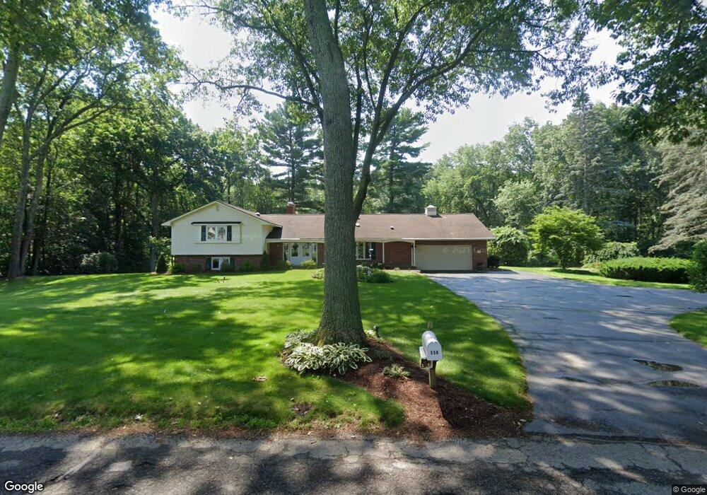
114 Armsby Rd Sutton, MA 01590
Estimated Value: $707,000 - $930,000
4
Beds
4
Baths
3,200
Sq Ft
$250/Sq Ft
Est. Value
About This Home
This home is located at 114 Armsby Rd, Sutton, MA 01590 and is currently estimated at $799,529, approximately $249 per square foot. 114 Armsby Rd is a home located in Worcester County with nearby schools including Sutton Elementary School, Sutton Middle School, and Sutton High School.
Ownership History
Date
Name
Owned For
Owner Type
Purchase Details
Closed on
Dec 20, 1996
Sold by
114 Armsby Rt and Herrmann Elizabeth
Bought by
Papke Ross R and Papke Nean W
Current Estimated Value
Purchase Details
Closed on
Dec 21, 1994
Sold by
Pleasant Valley Corp
Bought by
114 Armsby Road Rt
Purchase Details
Closed on
Jun 30, 1987
Sold by
Ermilio Francis G
Bought by
Pleasant Valley Corp
Create a Home Valuation Report for This Property
The Home Valuation Report is an in-depth analysis detailing your home's value as well as a comparison with similar homes in the area
Home Values in the Area
Average Home Value in this Area
Purchase History
| Date | Buyer | Sale Price | Title Company |
|---|---|---|---|
| Papke Ross R | $199,000 | -- | |
| 114 Armsby Road Rt | $147,000 | -- | |
| Pleasant Valley Corp | $270,000 | -- |
Source: Public Records
Mortgage History
| Date | Status | Borrower | Loan Amount |
|---|---|---|---|
| Open | Pleasant Valley Corp | $30,000 | |
| Open | Pleasant Valley Corp | $120,325 | |
| Closed | Pleasant Valley Corp | $10,000 |
Source: Public Records
Tax History
| Year | Tax Paid | Tax Assessment Tax Assessment Total Assessment is a certain percentage of the fair market value that is determined by local assessors to be the total taxable value of land and additions on the property. | Land | Improvement |
|---|---|---|---|---|
| 2025 | $7,555 | $628,500 | $228,800 | $399,700 |
| 2024 | $7,566 | $596,700 | $200,100 | $396,600 |
| 2023 | $7,876 | $568,700 | $180,700 | $388,000 |
| 2022 | $8,874 | $584,600 | $144,600 | $440,000 |
| 2021 | $7,685 | $480,300 | $144,600 | $335,700 |
| 2020 | $7,397 | $466,400 | $144,600 | $321,800 |
| 2019 | $7,485 | $453,100 | $144,600 | $308,500 |
| 2018 | $7,191 | $434,500 | $144,600 | $289,900 |
| 2017 | $7,003 | $424,400 | $127,100 | $297,300 |
| 2016 | $6,894 | $413,300 | $127,100 | $286,200 |
| 2015 | $6,645 | $398,400 | $127,100 | $271,300 |
| 2014 | $6,369 | $377,300 | $132,600 | $244,700 |
Source: Public Records
Map
Nearby Homes
- 229 Worcester-Providence Turnpike
- 175 Armsby Rd
- 1 Burbank Rd
- 14 Millers Way Unit D
- 32 Sibley Rd
- 63 Uxbridge Rd
- 5 Okemo Ridge Rd
- 82 Dodge Hill Rd
- 82 Central Turnpike
- 345 Central Turnpike
- 198 Uxbridge Rd
- 126 Burbank Rd
- 66 Buttonwood Ave
- 47 Singletary Ave
- 20 Wunschel Dr
- 5 Putnam Hill Rd
- 7 Leland Hill Rd
- 125 Singletary Ave
- 184 Pleasant St
- 183 Pleasant St Unit 2
- 1 Burnap Rd
- 7 Burnap Rd
- 118 Armsby Rd
- 118 Armsby Rd
- 118 Armsby Rd Unit 118
- 108 Armsby Rd
- 10 Burnap Rd
- 2 Burnap Rd
- 11 Fairway View Dr Unit 76
- 11 Fairway View Dr Unit 11
- 122 Armsby Rd
- 14 Fairway View Dr Unit 80
- 14 Fairway View Dr Unit 14
- 11 Burnap Rd
- 15 Fairway View Dr Unit 77
- 125 Armsby Rd
- 17 Fairway View Dr Unit 17
- 19 Fairway View Dr Unit 79
- 17 Fairway View Dr Unit 78
- 128 Armsby Rd -Rt 146
Your Personal Tour Guide
Ask me questions while you tour the home.