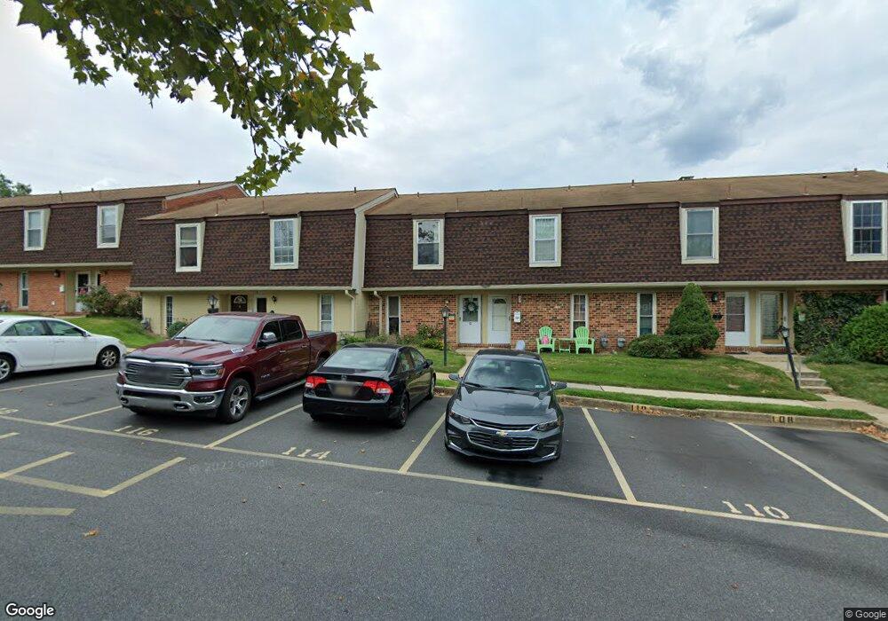
114 King William St Unit 114 Newark, DE 19711
Estimated Value: $186,749 - $198,000
2
Beds
2
Baths
992
Sq Ft
$194/Sq Ft
Est. Value
About This Home
This home is located at 114 King William St Unit 114, Newark, DE 19711 and is currently estimated at $192,916, approximately $194 per square foot. 114 King William St Unit 114 is a home located in New Castle County with nearby schools including Downes (John R.) Elementary School, Shue-Medill Middle School, and Newark High School.
Ownership History
Date
Name
Owned For
Owner Type
Purchase Details
Closed on
Jan 6, 2006
Sold by
Smagala Ryan and Walls Andrew M
Bought by
Olson Noel
Current Estimated Value
Home Financials for this Owner
Home Financials are based on the most recent Mortgage that was taken out on this home.
Original Mortgage
$73,600
Interest Rate
6.62%
Mortgage Type
Fannie Mae Freddie Mac
Purchase Details
Closed on
Jun 9, 2004
Sold by
Anobile Guy and Anobile Lynn
Bought by
Smagala Ryan and Walls Andrew M
Home Financials for this Owner
Home Financials are based on the most recent Mortgage that was taken out on this home.
Original Mortgage
$74,250
Interest Rate
6.75%
Mortgage Type
Purchase Money Mortgage
Create a Home Valuation Report for This Property
The Home Valuation Report is an in-depth analysis detailing your home's value as well as a comparison with similar homes in the area
Home Values in the Area
Average Home Value in this Area
Purchase History
Date | Buyer | Sale Price | Title Company |
---|---|---|---|
Olson Noel | $92,000 | None Available | |
Smagala Ryan | $82,500 | -- |
Source: Public Records
Mortgage History
Date | Status | Borrower | Loan Amount |
---|---|---|---|
Open | Olson Noel | $69,000 | |
Closed | Olson Noel | $77,500 | |
Closed | Olson Noel | $73,600 | |
Closed | Olson Noel J | $15,000 | |
Previous Owner | Smagala Ryan | $74,250 |
Source: Public Records
Tax History Compared to Growth
Tax History
Year | Tax Paid | Tax Assessment Tax Assessment Total Assessment is a certain percentage of the fair market value that is determined by local assessors to be the total taxable value of land and additions on the property. | Land | Improvement |
---|---|---|---|---|
2023 | $1,302 | $36,000 | $5,300 | $30,700 |
2022 | $1,288 | $36,000 | $5,300 | $30,700 |
2021 | $1,255 | $36,000 | $5,300 | $30,700 |
2020 | $1,219 | $36,000 | $5,300 | $30,700 |
2019 | $1,068 | $36,000 | $5,300 | $30,700 |
2018 | $1,044 | $36,000 | $5,300 | $30,700 |
2017 | $1,013 | $36,000 | $5,300 | $30,700 |
2016 | $1,010 | $36,000 | $5,300 | $30,700 |
2015 | $905 | $36,000 | $5,300 | $30,700 |
2014 | $905 | $36,000 | $5,300 | $30,700 |
Source: Public Records
Map
Nearby Homes
- 17 E Shetland Ct
- 100 W Shetland Ct
- 29 N Fawn Dr
- 27 N Fawn Dr Unit ELAN
- 3 Kayser Ct
- 5 Kayser Ct
- 26 Munro Rd
- 01a Leahy Dr
- 55 Buttercup Cir
- 102 Leahy Dr
- 104 Leahy Dr
- 03a Leahy Dr
- 04a Leahy Dr
- 02a Leahy Dr
- HAMPSHIRE Plan at Barksdale Crossing
- GALEN Plan at Barksdale Crossing
- HANOVER Plan at Barksdale Crossing
- HAYDEN Plan at Barksdale Crossing
- 22 Country Living Rd
- 405 Leahy Dr
- 116 King William St Unit 116
- 118 King William St Unit 118
- 110 King William St Unit 110
- 120 King William St Unit 120
- 108 King William St
- 122 King William St Unit 122
- 106 King William St Unit 106
- 124 King William St Unit 124
- 104 King William St Unit 104
- 126 King William St
- 102 King William St Unit 102
- 100 King William St Unit 100
- 130 King William St
- 132 King William St Unit 132
- 134 King William St Unit 134
- 136 King William St
- 128 King William St
- 138 King William St
- 142 King William St
- 168 King William St