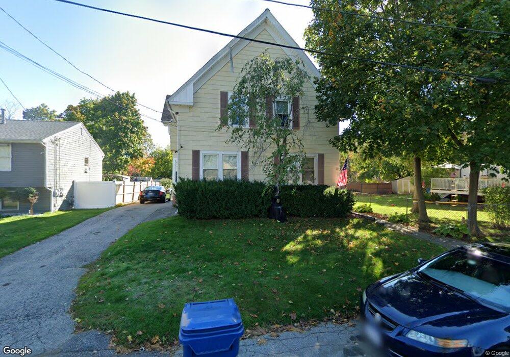
114 Lyman Ave Warwick, RI 02888
Norwood NeighborhoodEstimated Value: $429,670 - $513,000
5
Beds
2
Baths
1,928
Sq Ft
$253/Sq Ft
Est. Value
About This Home
This home is located at 114 Lyman Ave, Warwick, RI 02888 and is currently estimated at $487,668, approximately $252 per square foot. 114 Lyman Ave is a home located in Kent County with nearby schools including St. Peter School.
Ownership History
Date
Name
Owned For
Owner Type
Purchase Details
Closed on
Jun 23, 2017
Sold by
Hall Lucille M
Bought by
Hall Texsinia M and Hall Edward J
Current Estimated Value
Home Financials for this Owner
Home Financials are based on the most recent Mortgage that was taken out on this home.
Original Mortgage
$157,203
Outstanding Balance
$130,554
Interest Rate
4.05%
Mortgage Type
FHA
Estimated Equity
$357,114
Create a Home Valuation Report for This Property
The Home Valuation Report is an in-depth analysis detailing your home's value as well as a comparison with similar homes in the area
Home Values in the Area
Average Home Value in this Area
Purchase History
| Date | Buyer | Sale Price | Title Company |
|---|---|---|---|
| Hall Texsinia M | $180,000 | -- |
Source: Public Records
Mortgage History
| Date | Status | Borrower | Loan Amount |
|---|---|---|---|
| Open | Hall Texsinia M | $157,203 |
Source: Public Records
Tax History Compared to Growth
Tax History
| Year | Tax Paid | Tax Assessment Tax Assessment Total Assessment is a certain percentage of the fair market value that is determined by local assessors to be the total taxable value of land and additions on the property. | Land | Improvement |
|---|---|---|---|---|
| 2025 | $4,613 | $363,200 | $101,200 | $262,000 |
| 2024 | $4,491 | $310,400 | $88,000 | $222,400 |
| 2023 | $4,405 | $310,400 | $88,000 | $222,400 |
| 2022 | $3,999 | $213,500 | $57,000 | $156,500 |
| 2021 | $3,999 | $213,500 | $57,000 | $156,500 |
| 2020 | $3,999 | $213,500 | $57,000 | $156,500 |
| 2019 | $3,999 | $213,500 | $57,000 | $156,500 |
| 2018 | $3,401 | $163,500 | $57,000 | $106,500 |
| 2017 | $3,309 | $163,500 | $57,000 | $106,500 |
| 2016 | $3,309 | $163,500 | $57,000 | $106,500 |
| 2015 | $3,154 | $152,000 | $55,900 | $96,100 |
| 2014 | $3,049 | $152,000 | $55,900 | $96,100 |
| 2013 | $3,008 | $152,000 | $55,900 | $96,100 |
Source: Public Records
Map
Nearby Homes
- 27 Frederick St
- 35 Welfare Ave
- 35 Manson Ave
- 396 Elm St
- 447 Harrington Ave
- 1153 Post Rd
- 341 Sumner Ave
- 1052 Post Rd
- 120 Gould Ave
- 63 Massasoit Dr
- 110 Heath Ave
- 126 Fairfax Dr
- 150 Riverside Ave
- 158 Underwood Ave
- 15 Spruce Ave
- 93 Grotto Ave
- 81 Allen Ave
- 208 Negansett Ave
- 31 Celestia Ave
- 76 Massachusetts Ave
- 106 Lyman Ave
- 120 Lyman Ave
- 115 Lyman Ave
- 100 Lyman Ave
- 103 Lyman Ave
- 96 Lyman Ave
- 61 Frederick St
- 95 Lyman Ave
- 21 Frederick St
- 62 Frederick St
- 42 Phillips Ave
- 207 Norwood Ave
- 215 Norwood Ave
- 34 Phillips Ave
- 52 Phillips Ave
- 86 Lyman Ave
- 201 Norwood Ave
- 219 Norwood Ave
- 28 Phillips Ave
- 229 Norwood Ave