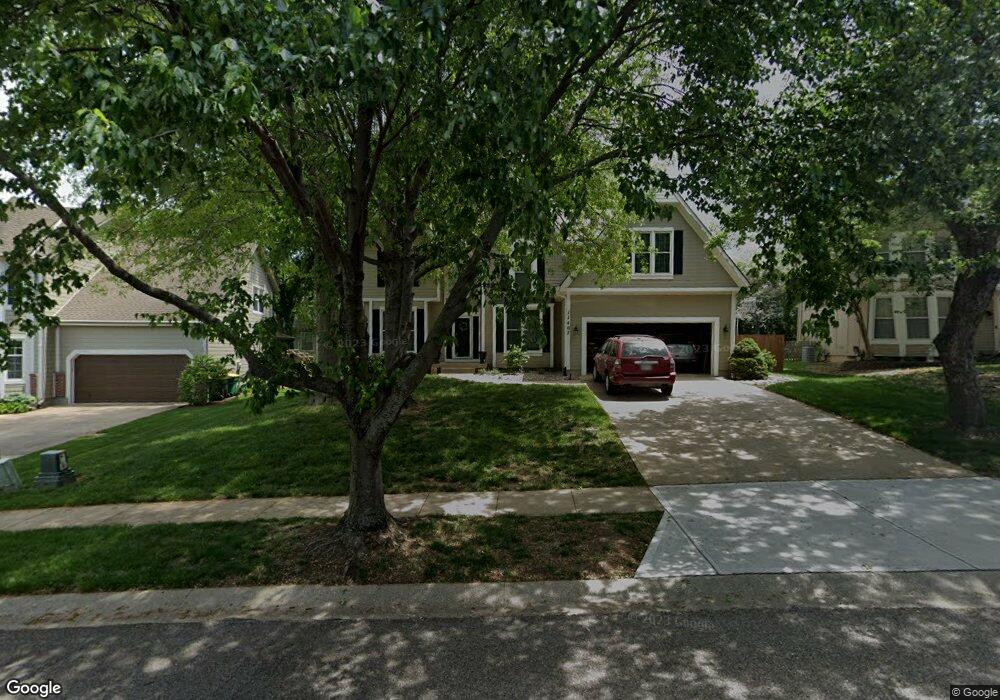
11407 Acuff Ln Lenexa, KS 66215
Estimated Value: $480,352 - $501,000
4
Beds
3
Baths
2,639
Sq Ft
$185/Sq Ft
Est. Value
About This Home
This home is located at 11407 Acuff Ln, Lenexa, KS 66215 and is currently estimated at $489,338, approximately $185 per square foot. 11407 Acuff Ln is a home located in Johnson County with nearby schools including Walnut Grove Elementary School, Pioneer Trail Middle School, and Olathe East Sr High School.
Ownership History
Date
Name
Owned For
Owner Type
Purchase Details
Closed on
Feb 2, 2023
Sold by
Cannon Lonnie R and Cannon Leslie S
Bought by
He Cannon Living Trust
Current Estimated Value
Purchase Details
Closed on
Feb 8, 2011
Sold by
Cannon Lonnie R and Cannon Leslie S
Bought by
Cannon Lonnie R and Cannon Leslie S
Purchase Details
Closed on
Nov 1, 2005
Sold by
Cannon Lonnie R and Cannon Leslie S
Bought by
Cannon Lonnie R and Cannon Leslie S
Purchase Details
Closed on
Nov 27, 2001
Sold by
Johnson Robert R and Johnson Diane M
Bought by
Cannon Lonnie R and Cannon Leslie S
Home Financials for this Owner
Home Financials are based on the most recent Mortgage that was taken out on this home.
Original Mortgage
$127,500
Interest Rate
6.59%
Create a Home Valuation Report for This Property
The Home Valuation Report is an in-depth analysis detailing your home's value as well as a comparison with similar homes in the area
Home Values in the Area
Average Home Value in this Area
Purchase History
| Date | Buyer | Sale Price | Title Company |
|---|---|---|---|
| He Cannon Living Trust | -- | -- | |
| Cannon Lonnie R | -- | None Available | |
| Cannon Lonnie R | -- | None Available | |
| Cannon Lonnie R | -- | Chicago Title Insurance Co |
Source: Public Records
Mortgage History
| Date | Status | Borrower | Loan Amount |
|---|---|---|---|
| Previous Owner | Cannon Lonnie R | $127,500 |
Source: Public Records
Tax History
| Year | Tax Paid | Tax Assessment Tax Assessment Total Assessment is a certain percentage of the fair market value that is determined by local assessors to be the total taxable value of land and additions on the property. | Land | Improvement |
|---|---|---|---|---|
| 2025 | $6,119 | $51,969 | $9,927 | $42,042 |
| 2024 | $6,119 | $49,899 | $9,023 | $40,876 |
| 2023 | $5,997 | $47,897 | $8,198 | $39,699 |
| 2022 | $5,072 | $39,491 | $7,454 | $32,037 |
| 2021 | $5,290 | $39,134 | $6,778 | $32,356 |
| 2020 | $5,045 | $36,938 | $6,778 | $30,160 |
| 2019 | $4,842 | $35,178 | $5,897 | $29,281 |
| 2018 | $4,893 | $35,167 | $5,897 | $29,270 |
| 2017 | $4,647 | $32,660 | $5,130 | $27,530 |
| 2016 | $4,267 | $30,647 | $5,130 | $25,517 |
| 2015 | $3,935 | $28,232 | $5,130 | $23,102 |
| 2013 | -- | $26,968 | $4,890 | $22,078 |
Source: Public Records
Map
Nearby Homes
- 14040 W 113th St
- 14036 W 113th St
- 14028 W 113th St
- 11238 S Rene St Unit 3002
- 11388 S Pflumm Rd
- 11274 S Pflumm Rd
- 11813 S Hallet St
- 11812 S Carriage Rd
- 11931 S Rene St
- 12844 W 110th Terrace
- 12786 W 110th Terrace
- 12722 W 110th Terrace
- 14441 W 122nd St
- 12715 W 117th St
- 11903 Noland St
- 10907 Gillette St
- 12659 W 110th Terrace
- 10902 Bradshaw St
- 10872 Bradshaw St
- 12606 W 110th Terrace Unit 86
- 11411 Acuff Ln
- 11403 Acuff Ln
- 11404 Mullen Rd
- 11408 Mullen Rd
- 11400 Mullen Rd
- 11415 Acuff Ln
- 11412 Mullen Rd
- 11406 Acuff Ln
- 11402 Acuff Ln
- 11410 Acuff Ln
- 11416 Mullen Rd
- 11332 Mullen Rd
- 11414 Acuff Ln
- 11330 Acuff Ln
- 11405 Mullen Rd
- 11409 Oakview Dr
- 11409 Mullen Rd
- 11401 Mullen Rd
- 11325 Acuff Ln
- 11413 Mullen Rd