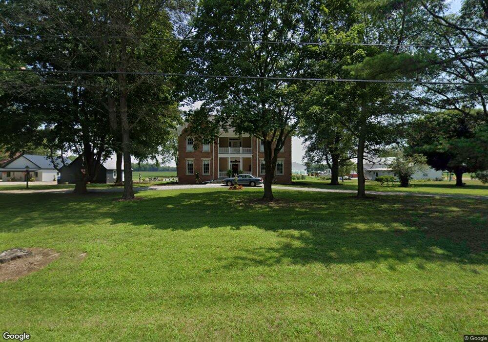
11425 S Jonesville Rd Columbus, IN 47201
Estimated Value: $469,000 - $595,000
4
Beds
3
Baths
5,701
Sq Ft
$95/Sq Ft
Est. Value
About This Home
This home is located at 11425 S Jonesville Rd, Columbus, IN 47201 and is currently estimated at $544,012, approximately $95 per square foot. 11425 S Jonesville Rd is a home located in Bartholomew County with nearby schools including Mount Healthy Elementary School, Central Middle School, and Columbus East High School.
Ownership History
Date
Name
Owned For
Owner Type
Purchase Details
Closed on
Feb 17, 2023
Sold by
Cole William Jay
Bought by
Burbrink Rebecca Gail
Current Estimated Value
Purchase Details
Closed on
Sep 9, 2003
Sold by
Bell Arthur T and Jo Betty
Bought by
Cole William Jay and Cole Karen L
Purchase Details
Closed on
Jun 28, 1999
Sold by
Lee Kinsey Steven and Joan Helen
Bought by
Bell Arthur T and Bell Betty Jo
Create a Home Valuation Report for This Property
The Home Valuation Report is an in-depth analysis detailing your home's value as well as a comparison with similar homes in the area
Home Values in the Area
Average Home Value in this Area
Purchase History
| Date | Buyer | Sale Price | Title Company |
|---|---|---|---|
| Burbrink Rebecca Gail | $450,000 | Security Title Services | |
| Cole William Jay | $275,000 | -- | |
| Bell Arthur T | -- | -- |
Source: Public Records
Tax History Compared to Growth
Tax History
| Year | Tax Paid | Tax Assessment Tax Assessment Total Assessment is a certain percentage of the fair market value that is determined by local assessors to be the total taxable value of land and additions on the property. | Land | Improvement |
|---|---|---|---|---|
| 2024 | $5,754 | $635,300 | $55,700 | $579,600 |
| 2023 | $2,979 | $350,100 | $36,700 | $313,400 |
| 2022 | $2,940 | $318,600 | $35,700 | $282,900 |
| 2021 | $2,647 | $283,500 | $29,200 | $254,300 |
| 2020 | $2,679 | $283,500 | $29,200 | $254,300 |
| 2019 | $2,321 | $281,500 | $30,200 | $251,300 |
| 2018 | $2,179 | $264,100 | $30,300 | $233,800 |
| 2017 | $2,068 | $251,900 | $30,000 | $221,900 |
| 2016 | $1,791 | $235,000 | $30,200 | $204,800 |
| 2014 | $1,966 | $241,500 | $31,000 | $210,500 |
Source: Public Records
Map
Nearby Homes
- Lot 45 Taylor Dr at Taylor Ct
- 5502 E Karlsway Dr
- 181 W 550 S
- 407 Mill St
- 1001 E 450 S
- 23A E 750 S
- 6594 S Jonesville Rd
- 6354 S Jonesville Rd
- 9500 E 600 S
- 5974 S Jonesville Rd
- 16030 S Ferguson Rd
- 3660 E 300 S
- 103 Lorney St
- 619 Falcon Dr
- 403 Railroad St
- 201 Poplar St
- 141 Dawson St
- 234 Lincoln St
- 467 Dawson St
- 1 W Cr 990 North Tract "G"
- 11491 S Jonesville Rd
- 11665 S Jonesville Rd
- 11170 S Jonesville Rd
- 11130 S Jonesville Rd
- 11785 S Jonesville Rd
- 11430 S Jonesville Rd
- 11630 S Jonesville Rd
- 11810 S Jonesville Rd
- 10960 S Jonesville Rd
- 11920 S Jonesville Rd
- 10900 S Jonesville Rd
- 12090 S Jonesville Rd
- 11990 S Jonesville Rd
- 12120 S Jonesville Rd
- 3201 E 650 S
- 10580 S Jonesville Rd
- 12215 S Jonesville Rd
- 10460 S Jonesville Rd
- 12460 S Jonesville Rd