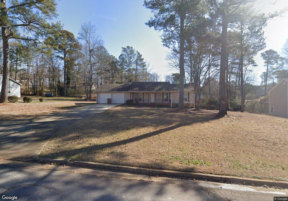
115 Farmbrook Trail Stockbridge, GA 30281
Estimated Value: $218,000 - $237,000
3
Beds
2
Baths
1,555
Sq Ft
$146/Sq Ft
Est. Value
About This Home
This home is located at 115 Farmbrook Trail, Stockbridge, GA 30281 and is currently estimated at $227,489, approximately $146 per square foot. 115 Farmbrook Trail is a home located in Henry County with nearby schools including Austin Road Elementary School, Austin Road Middle School, and Woodland High School.
Ownership History
Date
Name
Owned For
Owner Type
Purchase Details
Closed on
Jun 18, 2020
Sold by
Us Sfe Asset Co 3 Llc
Bought by
Baf Assets Llc
Current Estimated Value
Purchase Details
Closed on
Feb 19, 2016
Sold by
Jeff 1 Llc
Bought by
Us Sfe Asset Co 3 Llc
Purchase Details
Closed on
Sep 25, 2014
Sold by
Bryson Howard
Bought by
Jeff 1 Llc
Purchase Details
Closed on
May 28, 2003
Sold by
Danes Angela M
Bought by
Bryson Howard E and Bryson Cathy
Home Financials for this Owner
Home Financials are based on the most recent Mortgage that was taken out on this home.
Original Mortgage
$85,410
Interest Rate
5.42%
Mortgage Type
New Conventional
Purchase Details
Closed on
Jun 2, 1994
Sold by
Ussery C Lamar and Ussey Lisa G
Bought by
Danes Bill P and Danes Angela M
Home Financials for this Owner
Home Financials are based on the most recent Mortgage that was taken out on this home.
Original Mortgage
$68,456
Interest Rate
8.5%
Mortgage Type
FHA
Create a Home Valuation Report for This Property
The Home Valuation Report is an in-depth analysis detailing your home's value as well as a comparison with similar homes in the area
Home Values in the Area
Average Home Value in this Area
Purchase History
| Date | Buyer | Sale Price | Title Company |
|---|---|---|---|
| Baf Assets Llc | $1,753,829 | -- | |
| Us Sfe Asset Co 3 Llc | -- | -- | |
| Jeff 1 Llc | $80,000 | -- | |
| Bryson Howard E | $94,900 | -- | |
| Danes Bill P | $16,000 | -- |
Source: Public Records
Mortgage History
| Date | Status | Borrower | Loan Amount |
|---|---|---|---|
| Previous Owner | Bryson Howard E | $85,410 | |
| Previous Owner | Danes Bill P | $68,456 |
Source: Public Records
Tax History
| Year | Tax Paid | Tax Assessment Tax Assessment Total Assessment is a certain percentage of the fair market value that is determined by local assessors to be the total taxable value of land and additions on the property. | Land | Improvement |
|---|---|---|---|---|
| 2025 | $3,988 | $99,880 | $11,333 | $88,547 |
| 2024 | $3,988 | $104,680 | $12,000 | $92,680 |
| 2023 | $3,471 | $89,440 | $10,000 | $79,440 |
| 2022 | $2,918 | $75,040 | $10,000 | $65,040 |
| 2021 | $2,398 | $61,480 | $10,000 | $51,480 |
| 2020 | $2,102 | $53,760 | $8,000 | $45,760 |
| 2019 | $1,989 | $50,800 | $8,000 | $42,800 |
| 2018 | $1,837 | $46,840 | $8,000 | $38,840 |
| 2016 | $1,246 | $31,440 | $6,000 | $25,440 |
| 2015 | $1,097 | $31,440 | $6,000 | $25,440 |
| 2014 | -- | $29,360 | $4,800 | $24,560 |
Source: Public Records
Map
Nearby Homes
- 217 Farmbrook Pkwy Unit 2
- 120 Farmbrook Trail
- 122 Farmbrook Trail
- 225 Farmbrook Pkwy
- 203 Farmbrook Pkwy
- 226 Farmbrook Pkwy
- 232 Farmbrook Pkwy
- 1411 Fairview Rd
- 200 Johns Creek Ln
- 194 Johns Creek Ln
- 112 Fairview Dr
- 107 Parkview Dr
- 127 Fairview Way Unit 1
- 780 Gardner Rd
- 128 Crown Glen Way
- 60 Melanie Dr
- 437 Branch Forest Way
- 643 Patillo Rd
- 1160 Fairview Rd
- 861 Gardner Rd
- 115 Farmbrook Trail
- 113 Farmbrook Trail
- 117 Farmbrook Trail
- 117 Farmbrook Trail
- 214 Farmbrook Pkwy
- 114 Farmbrook Trail
- 212 Farmbrook Pkwy Unit 2
- 116 Farmbrook Trail Unit 1
- 111 Farmbrook Trail Unit 1
- 112 Farmbrook Trail
- 119 Farmbrook Trail Unit 1
- 210 Farmbrook Pkwy Unit 2
- 218 Farmbrook Pkwy
- 215 Farmbrook Pkwy Unit 2
- 115 Martin Creek Ct
- 213 Farmbrook Pkwy
- 110 Farmbrook Trail Unit 1
- 109 Farmbrook Trail
- 105 Martin Creek Ct
- 208 Farmbrook Pkwy
Your Personal Tour Guide
Ask me questions while you tour the home.