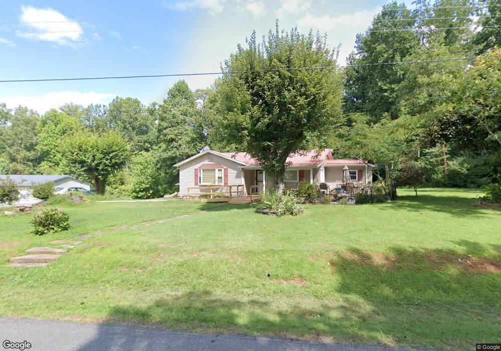
1156 Avery Rd Morganton, NC 28655
Estimated Value: $164,631 - $310,000
3
Beds
2
Baths
1,306
Sq Ft
$176/Sq Ft
Est. Value
About This Home
This home is located at 1156 Avery Rd, Morganton, NC 28655 and is currently estimated at $230,408, approximately $176 per square foot. 1156 Avery Rd is a home located in Burke County with nearby schools including Oak Hill Elementary School, Table Rock Middle School, and Freedom High School.
Ownership History
Date
Name
Owned For
Owner Type
Purchase Details
Closed on
Oct 29, 2014
Sold by
Collette Ralph E and Collette Brenda Joyce Brown
Bought by
Collette Ralph E and Collette Brenda Joyce Brown
Current Estimated Value
Home Financials for this Owner
Home Financials are based on the most recent Mortgage that was taken out on this home.
Original Mortgage
$72,000
Interest Rate
4.29%
Mortgage Type
Credit Line Revolving
Create a Home Valuation Report for This Property
The Home Valuation Report is an in-depth analysis detailing your home's value as well as a comparison with similar homes in the area
Home Values in the Area
Average Home Value in this Area
Purchase History
| Date | Buyer | Sale Price | Title Company |
|---|---|---|---|
| Collette Ralph E | -- | None Available |
Source: Public Records
Mortgage History
| Date | Status | Borrower | Loan Amount |
|---|---|---|---|
| Closed | Collette Ralph E | $72,000 |
Source: Public Records
Tax History
| Year | Tax Paid | Tax Assessment Tax Assessment Total Assessment is a certain percentage of the fair market value that is determined by local assessors to be the total taxable value of land and additions on the property. | Land | Improvement |
|---|---|---|---|---|
| 2025 | $610 | $81,622 | $3,960 | $77,662 |
| 2024 | $610 | $81,622 | $3,960 | $77,662 |
| 2023 | $610 | $81,622 | $3,960 | $77,662 |
| 2022 | $500 | $53,303 | $2,880 | $50,423 |
| 2021 | $494 | $53,303 | $2,880 | $50,423 |
| 2020 | $490 | $53,303 | $2,880 | $50,423 |
| 2019 | $490 | $53,303 | $2,880 | $50,423 |
| 2018 | $491 | $53,382 | $2,880 | $50,502 |
| 2017 | $489 | $53,382 | $2,880 | $50,502 |
| 2016 | $476 | $53,382 | $2,880 | $50,502 |
| 2015 | $473 | $53,382 | $2,880 | $50,502 |
| 2014 | $472 | $53,382 | $2,880 | $50,502 |
| 2013 | $466 | $53,382 | $2,880 | $50,502 |
Source: Public Records
Map
Nearby Homes
- 2937 Frank Whisnant Rd
- 3026 Coventry Dr
- 1446 Bridlewood Ln
- 1052 Benfield Woods
- 3666 Grandview Dr
- 3680 Grandview Dr
- 1156 Oak Forest Dr
- 0 Oak Forest Dr
- 1629 Nc 126
- 1437 Oak Hill Dr
- 2556 Nc 126
- 1088 Faith Ct
- 1053 Faith Ct
- 1095 Faith Ct
- 1022 Faith Ct
- 1080 Faith Ct
- 1096 Faith Ct
- 1079 Faith Ct
- 1735 Roy Caldwell St
- 1008 Faith Ct
- 1170 Avery Rd
- 1171 Avery Rd
- 1186 Avery Rd
- 1198 Avery Rd
- 3065 Frank Whisnant Rd
- 1135 Avery Rd
- 1115 Avery Rd
- 3006 Frank Whisnant Rd
- 2990 Frank Whisnant Rd
- 1224 Avery Rd
- 1213 Avery Rd
- 2977 Frank Whisnant Rd
- 3073 Frank Whisnant Rd
- 3119 Frank Whisnant Rd
- 2926 Frank Whisnant Rd Unit 2928
- 2976 Frank Whisnant Rd
- 1235 Avery Rd
- 2965 Wild Blue Ln
- 2955 Frank Whisnant Rd
- 1088 Linnaean Dr
Your Personal Tour Guide
Ask me questions while you tour the home.