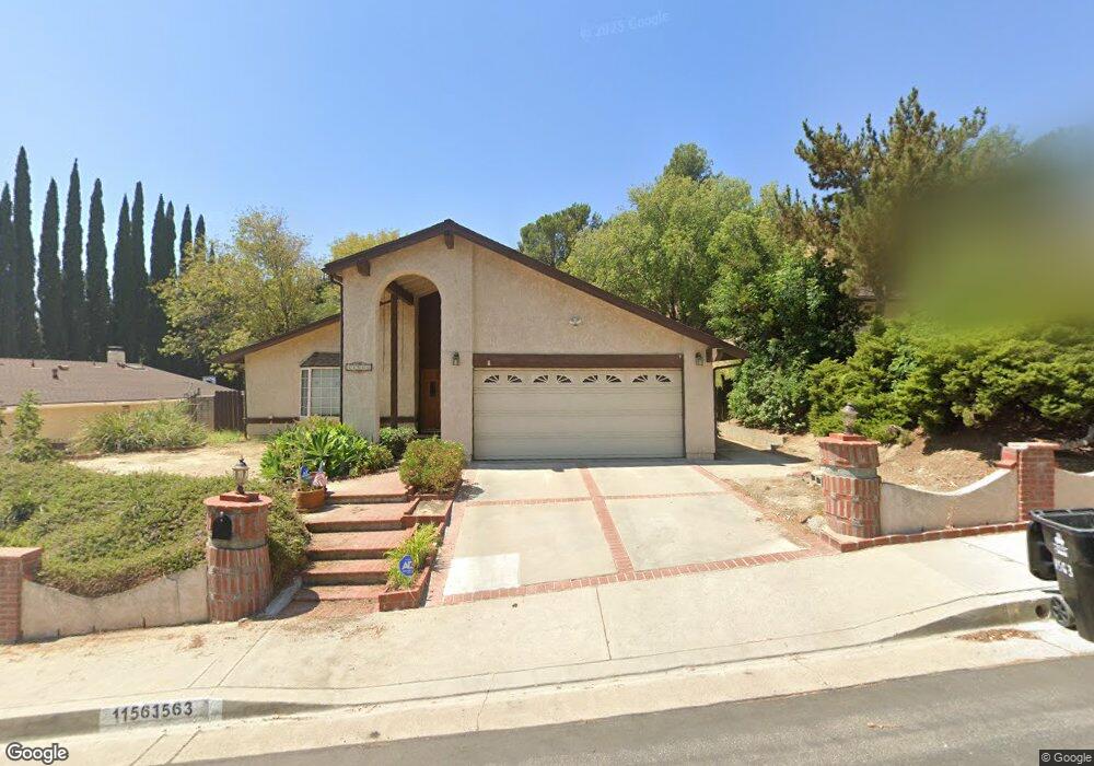
11563 Baird Ave Porter Ranch, CA 91326
Porter Ranch NeighborhoodEstimated Value: $1,076,562 - $1,217,000
3
Beds
3
Baths
1,904
Sq Ft
$608/Sq Ft
Est. Value
About This Home
This home is located at 11563 Baird Ave, Porter Ranch, CA 91326 and is currently estimated at $1,157,391, approximately $607 per square foot. 11563 Baird Ave is a home located in Los Angeles County with nearby schools including Robert Frost Middle School, Northridge Academy High, and Valley Academy of Arts & Sciences.
Ownership History
Date
Name
Owned For
Owner Type
Purchase Details
Closed on
Apr 8, 2021
Sold by
Bales Glenn A and Bales Susan
Bought by
Bales Glenn A and Bales Susan Y
Current Estimated Value
Purchase Details
Closed on
Nov 27, 2002
Sold by
Bales Glen A and Bales Susan Y
Bought by
Bales Glenn and Bales Susan
Home Financials for this Owner
Home Financials are based on the most recent Mortgage that was taken out on this home.
Original Mortgage
$175,000
Interest Rate
6.28%
Purchase Details
Closed on
Feb 20, 2002
Sold by
Bales Glenn A and Bales Susan Y
Bought by
Bales Glenn A and Bales Susan Y
Create a Home Valuation Report for This Property
The Home Valuation Report is an in-depth analysis detailing your home's value as well as a comparison with similar homes in the area
Home Values in the Area
Average Home Value in this Area
Purchase History
| Date | Buyer | Sale Price | Title Company |
|---|---|---|---|
| Bales Glenn A | -- | None Available | |
| Bales Glenn | -- | Old Republic Title Company | |
| Bales Glenn A | -- | -- |
Source: Public Records
Mortgage History
| Date | Status | Borrower | Loan Amount |
|---|---|---|---|
| Closed | Bales Glenn | $175,000 |
Source: Public Records
Tax History
| Year | Tax Paid | Tax Assessment Tax Assessment Total Assessment is a certain percentage of the fair market value that is determined by local assessors to be the total taxable value of land and additions on the property. | Land | Improvement |
|---|---|---|---|---|
| 2025 | $4,743 | $368,467 | $121,852 | $246,615 |
| 2024 | $4,743 | $361,243 | $119,463 | $241,780 |
| 2023 | $4,657 | $354,161 | $117,121 | $237,040 |
| 2022 | $4,452 | $347,218 | $114,825 | $232,393 |
| 2021 | $4,390 | $340,411 | $112,574 | $227,837 |
| 2020 | $4,428 | $336,921 | $111,420 | $225,501 |
| 2019 | $4,265 | $330,316 | $109,236 | $221,080 |
| 2018 | $4,121 | $323,841 | $107,095 | $216,746 |
| 2016 | $3,925 | $311,269 | $102,938 | $208,331 |
| 2015 | $3,870 | $306,594 | $101,392 | $205,202 |
| 2014 | $3,892 | $300,589 | $99,406 | $201,183 |
Source: Public Records
Map
Nearby Homes
- 11753 Castillo Ln
- 18511 Dylan St
- 11830 Killimore Ave
- 18520 Asuncion St
- 11813 Killimore Ave
- 18772 Algiers St
- 11369 Darby Ave
- 11413 Etiwanda Ave
- 18409 Hampton Ct
- 11357 Yolanda Ave
- 11772 Monte Leon Way
- 11355 Pala Mesa Dr
- 11215 Wilbur Ave
- 18371 Lahey St
- 19137 Index St Unit 9
- 12036 Darby Ave
- 18810 Kirkcolm Ln
- 11577 Newcastle Ave
- 19140 Lahey St Unit 4
- 18169 N Knoll Hill
- 11557 Baird Ave
- 11571 Baird Ave
- 11549 Baird Ave
- 11577 Baird Ave
- 11583 Baird Ave
- 11518 Lyster Ave
- 11526 Lyster Ave
- 18637 Nau Ave
- 11514 Lyster Ave
- 18641 Nau Ave
- 18631 Nau Ave
- 11564 Baird Ave
- 11532 Lyster Ave
- 11572 Baird Ave
- 11558 Baird Ave
- 18670 Brymer St
- 11591 Baird Ave
- 11538 Lyster Ave
- 11542 Baird Ave
- 11506 Lyster Ave