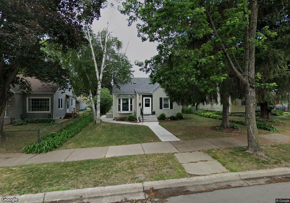
1163 1163 Smith Ave S West St. Paul, MN 55118
Estimated Value: $319,927 - $365,000
3
Beds
2
Baths
982
Sq Ft
$349/Sq Ft
Est. Value
About This Home
This home is located at 1163 1163 Smith Ave S, West St. Paul, MN 55118 and is currently estimated at $342,232, approximately $348 per square foot. 1163 1163 Smith Ave S is a home located in Dakota County with nearby schools including Moreland Arts & Health Sciences Magnet School, Heritage E-STEM Magnet School, and Two Rivers High School.
Ownership History
Date
Name
Owned For
Owner Type
Purchase Details
Closed on
May 28, 2010
Sold by
Huettl Joseph Patrick and Huettl Libby Kay
Bought by
Casper Daniel
Current Estimated Value
Home Financials for this Owner
Home Financials are based on the most recent Mortgage that was taken out on this home.
Original Mortgage
$4,149
Outstanding Balance
$2,804
Interest Rate
5.14%
Mortgage Type
FHA
Estimated Equity
$339,428
Purchase Details
Closed on
Nov 29, 2007
Sold by
Feidt Joseph P and Feidt Rhonda
Bought by
Ribar Libby Kay and Huett Joseph Patrick
Create a Home Valuation Report for This Property
The Home Valuation Report is an in-depth analysis detailing your home's value as well as a comparison with similar homes in the area
Home Values in the Area
Average Home Value in this Area
Purchase History
| Date | Buyer | Sale Price | Title Company |
|---|---|---|---|
| Casper Daniel | $172,000 | Burnet Title | |
| Ribar Libby Kay | $216,500 | -- |
Source: Public Records
Mortgage History
| Date | Status | Borrower | Loan Amount |
|---|---|---|---|
| Open | Casper Daniel | $4,149 |
Source: Public Records
Tax History Compared to Growth
Tax History
| Year | Tax Paid | Tax Assessment Tax Assessment Total Assessment is a certain percentage of the fair market value that is determined by local assessors to be the total taxable value of land and additions on the property. | Land | Improvement |
|---|---|---|---|---|
| 2024 | $3,288 | $264,300 | $62,700 | $201,600 |
| 2023 | $3,288 | $276,000 | $66,500 | $209,500 |
| 2022 | $2,774 | $255,600 | $66,200 | $189,400 |
| 2021 | $2,732 | $225,300 | $57,600 | $167,700 |
| 2020 | $2,536 | $220,800 | $54,800 | $166,000 |
| 2019 | $2,424 | $201,900 | $52,200 | $149,700 |
| 2018 | $2,063 | $186,100 | $48,800 | $137,300 |
| 2017 | $1,880 | $168,600 | $46,500 | $122,100 |
| 2016 | $1,911 | $150,900 | $42,300 | $108,600 |
| 2015 | $1,791 | $129,312 | $35,121 | $94,191 |
| 2014 | -- | $116,995 | $31,833 | $85,162 |
| 2013 | -- | $106,095 | $28,642 | $77,453 |
Source: Public Records
Map
Nearby Homes
- 1095 Cherokee Ave
- 1062 Ohio St
- 8 Dorset Rd
- 1164 Dodd Rd
- 999 Seminole Ave
- 1174 Dodd Rd
- 421 Ruby Dr
- 967 Cherokee Ave
- 389 Edith Dr
- 63 Langer Cir
- 913 Ottawa Ave
- 158 Southwind Ln
- 1000 Winston Cir
- 625 Ivy Falls Ave
- 69 Langer Cir
- 606 Sutcliff Cir
- 1057 Winslow Ave
- 1016 Bidwell St
- 950 Bellows St
- 822 Smith Ave S
- 1167 1167 Smith-Avenue-s
- 1158 1158 Smith Ave S
- 1163 Smith Ave S
- 1162 Smith Ave S
- 1167 Smith Ave S
- 1166 Smith Ave S
- 1163 Smith Ave S
- 1158 Smith Ave S
- 1157 Smith Ave S
- 1167 Smith Ave S
- 1172 Smith Ave S
- 1153 Smith Ave S
- 1173 Smith Ave S
- 1152 Smith Ave S
- 1148 1148 Smith Ave S
- 1149 Smith Ave S
- 1148 Smith Ave S
- 1144 1144 Smith-Avenue-s
- 1145 Smith Ave S
- 404 Orme St W