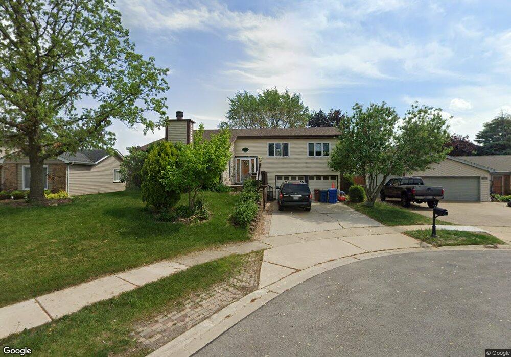
117 Brahms Ct Glendale Heights, IL 60139
Estimated Value: $394,104 - $439,000
4
Beds
3
Baths
2,301
Sq Ft
$183/Sq Ft
Est. Value
About This Home
This home is located at 117 Brahms Ct, Glendale Heights, IL 60139 and is currently estimated at $420,276, approximately $182 per square foot. 117 Brahms Ct is a home located in DuPage County with nearby schools including Marquardt Middle School, Glenbard East High School, and St Isidore School.
Ownership History
Date
Name
Owned For
Owner Type
Purchase Details
Closed on
Jul 23, 2022
Sold by
Kostner and Patricia
Bought by
Robert And Patricia Kostner Joint Revocable T
Current Estimated Value
Purchase Details
Closed on
Jun 25, 1998
Sold by
Mazurski Thaddeus A and Mazurski Melanie
Bought by
Kostner Robert A and Kostner Patricia
Home Financials for this Owner
Home Financials are based on the most recent Mortgage that was taken out on this home.
Original Mortgage
$154,500
Interest Rate
7.27%
Create a Home Valuation Report for This Property
The Home Valuation Report is an in-depth analysis detailing your home's value as well as a comparison with similar homes in the area
Home Values in the Area
Average Home Value in this Area
Purchase History
| Date | Buyer | Sale Price | Title Company |
|---|---|---|---|
| Robert And Patricia Kostner Joint Revocable T | -- | Hess Law Firm Llc | |
| Kostner Robert A | $163,000 | Chicago Title Insurance Co |
Source: Public Records
Mortgage History
| Date | Status | Borrower | Loan Amount |
|---|---|---|---|
| Previous Owner | Kostner Robert A | $154,500 |
Source: Public Records
Tax History Compared to Growth
Tax History
| Year | Tax Paid | Tax Assessment Tax Assessment Total Assessment is a certain percentage of the fair market value that is determined by local assessors to be the total taxable value of land and additions on the property. | Land | Improvement |
|---|---|---|---|---|
| 2024 | $9,024 | $105,971 | $24,997 | $80,974 |
| 2023 | $8,430 | $96,910 | $22,860 | $74,050 |
| 2022 | $9,080 | $96,290 | $22,710 | $73,580 |
| 2021 | $8,923 | $91,490 | $21,580 | $69,910 |
| 2020 | $8,418 | $89,250 | $21,050 | $68,200 |
| 2019 | $8,097 | $85,770 | $20,230 | $65,540 |
| 2018 | $8,761 | $84,770 | $19,700 | $65,070 |
| 2017 | $8,390 | $78,570 | $18,260 | $60,310 |
| 2016 | $7,995 | $72,720 | $16,900 | $55,820 |
| 2015 | $7,852 | $67,860 | $15,770 | $52,090 |
| 2014 | $7,167 | $62,060 | $15,770 | $46,290 |
| 2013 | $7,202 | $64,180 | $16,310 | $47,870 |
Source: Public Records
Map
Nearby Homes
- 2018 Stonefield Dr
- 133 Harding Ct
- 89 Stonefield Dr
- 169 E Lake Ridge Dr Unit 21
- 2257 Lake Ridge Dr Unit 74
- 67 Stonefield Dr
- 187 W Army Trail Rd
- 201 N Waters Edge Dr Unit 101
- 161 N Waters Edge Dr Unit 202
- 279 Blue Spruce Ln
- 39 Mill Pond Dr
- 1900 Basswood Ln
- 2158 College Dr Unit 7
- 1943 Towner Ln
- 2155 College Dr Unit 7
- 241 Army Trail Rd
- 1941 Aspen Ln
- 258 Thrasher St
- 307 E Alpine Dr
- 1760 Lombard Ct