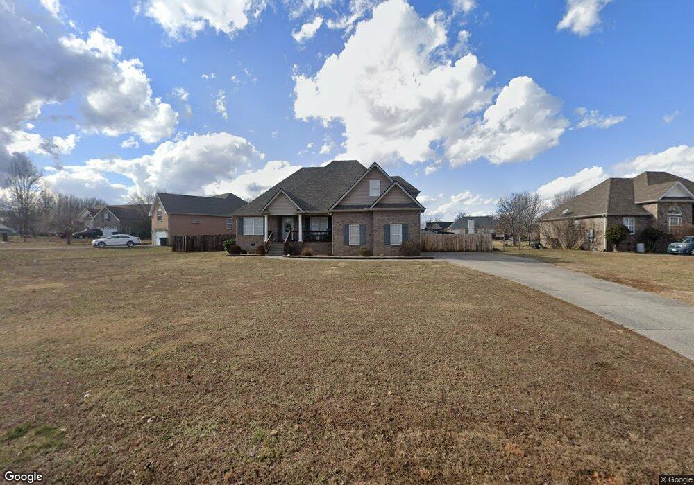
117 Emma Dr Portland, TN 37148
Estimated Value: $405,000 - $441,000
--
Bed
3
Baths
1,861
Sq Ft
$226/Sq Ft
Est. Value
About This Home
This home is located at 117 Emma Dr, Portland, TN 37148 and is currently estimated at $421,167, approximately $226 per square foot. 117 Emma Dr is a home located in Sumner County with nearby schools including Watt Hardison Elementary School, Portland West Middle School, and Portland High School.
Ownership History
Date
Name
Owned For
Owner Type
Purchase Details
Closed on
Feb 28, 2013
Sold by
Benjamin Arthur V and Gray-Benjamin Angela R
Bought by
Blackmore Steven A and Blackmore Christina L
Current Estimated Value
Home Financials for this Owner
Home Financials are based on the most recent Mortgage that was taken out on this home.
Original Mortgage
$173,552
Outstanding Balance
$120,413
Interest Rate
3.4%
Mortgage Type
VA
Estimated Equity
$300,754
Purchase Details
Closed on
Nov 10, 2005
Sold by
Suttle Patrick
Bought by
Benjamin Arthur and Gray Benjamin Angela R
Home Financials for this Owner
Home Financials are based on the most recent Mortgage that was taken out on this home.
Original Mortgage
$166,155
Interest Rate
6%
Mortgage Type
Fannie Mae Freddie Mac
Purchase Details
Closed on
Feb 1, 2005
Sold by
Mcglothlin James Hughes and Mcglothlin Judy Karen Brown
Bought by
Suttle Patrick
Create a Home Valuation Report for This Property
The Home Valuation Report is an in-depth analysis detailing your home's value as well as a comparison with similar homes in the area
Home Values in the Area
Average Home Value in this Area
Purchase History
| Date | Buyer | Sale Price | Title Company |
|---|---|---|---|
| Blackmore Steven A | $169,900 | Foundation Title & Escrow | |
| Benjamin Arthur | $174,900 | Realty Title & Escrow Co Inc | |
| Suttle Patrick | $19,000 | -- |
Source: Public Records
Mortgage History
| Date | Status | Borrower | Loan Amount |
|---|---|---|---|
| Open | Blackmore Steven A | $173,552 | |
| Previous Owner | Benjamin Arthur | $166,155 |
Source: Public Records
Tax History Compared to Growth
Tax History
| Year | Tax Paid | Tax Assessment Tax Assessment Total Assessment is a certain percentage of the fair market value that is determined by local assessors to be the total taxable value of land and additions on the property. | Land | Improvement |
|---|---|---|---|---|
| 2025 | $1,377 | $96,900 | $0 | $0 |
| 2024 | $1,377 | $96,900 | $15,000 | $81,900 |
| 2023 | $1,979 | $57,975 | $8,750 | $49,225 |
| 2022 | $1,926 | $57,975 | $8,750 | $49,225 |
| 2021 | $1,926 | $57,975 | $8,750 | $49,225 |
| 2020 | $1,926 | $57,975 | $8,750 | $49,225 |
| 2019 | $2,622 | $0 | $0 | $0 |
| 2018 | $1,672 | $0 | $0 | $0 |
| 2017 | $1,586 | $0 | $0 | $0 |
| 2016 | $1,586 | $0 | $0 | $0 |
| 2015 | -- | $0 | $0 | $0 |
| 2014 | -- | $0 | $0 | $0 |
Source: Public Records
Map
Nearby Homes
- 128 Emma Dr
- 229 Westland St
- 104 Mesa Dr
- 135 Irish Oaks Dr
- 727A N Russell St
- 115 Sunset Place
- 725B N Russell St
- 207 Meadow Ln
- 730 N Russell St
- 116 Chad St E
- 746 N Russell St
- 1001 Chad St W
- 101 Jasmine Way
- 136A Wind Wood Dr
- 510 N Russell St
- 201 Moore Ave
- 137 Bryan James Ln
- 419 N Russell St
- 400 Cloudland Dr
- 404 Cloudland Dr