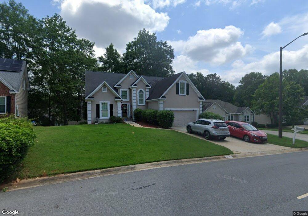
117 Springfield Blvd Macon, GA 31210
Estimated Value: $221,000 - $254,000
3
Beds
3
Baths
1,607
Sq Ft
$148/Sq Ft
Est. Value
About This Home
This home is located at 117 Springfield Blvd, Macon, GA 31210 and is currently estimated at $238,239, approximately $148 per square foot. 117 Springfield Blvd is a home located in Bibb County with nearby schools including Springdale Elementary School, Howard Middle School, and Howard High School.
Ownership History
Date
Name
Owned For
Owner Type
Purchase Details
Closed on
Jul 28, 2021
Sold by
Dumas Derek M and Dumas Harriett L
Bought by
Duncan Kenneth
Current Estimated Value
Home Financials for this Owner
Home Financials are based on the most recent Mortgage that was taken out on this home.
Original Mortgage
$179,000
Outstanding Balance
$162,489
Interest Rate
2.93%
Mortgage Type
VA
Estimated Equity
$75,750
Purchase Details
Closed on
Apr 23, 2003
Bought by
Dumas Derek M and Dumas Harriett L
Create a Home Valuation Report for This Property
The Home Valuation Report is an in-depth analysis detailing your home's value as well as a comparison with similar homes in the area
Home Values in the Area
Average Home Value in this Area
Purchase History
| Date | Buyer | Sale Price | Title Company |
|---|---|---|---|
| Duncan Kenneth | $179,000 | None Available | |
| Dumas Derek M | $138,500 | -- |
Source: Public Records
Mortgage History
| Date | Status | Borrower | Loan Amount |
|---|---|---|---|
| Open | Duncan Kenneth | $179,000 |
Source: Public Records
Tax History Compared to Growth
Tax History
| Year | Tax Paid | Tax Assessment Tax Assessment Total Assessment is a certain percentage of the fair market value that is determined by local assessors to be the total taxable value of land and additions on the property. | Land | Improvement |
|---|---|---|---|---|
| 2025 | -- | $90,119 | $12,000 | $78,119 |
| 2024 | -- | $86,722 | $12,000 | $74,722 |
| 2023 | $0 | $77,930 | $10,000 | $67,930 |
| 2022 | $2,631 | $69,226 | $10,170 | $59,056 |
| 2021 | $2,408 | $63,371 | $9,450 | $53,921 |
| 2020 | $2,460 | $63,371 | $9,450 | $53,921 |
| 2019 | $2,204 | $56,309 | $8,550 | $47,759 |
| 2018 | $3,556 | $56,309 | $8,550 | $47,759 |
| 2017 | $1,922 | $51,300 | $7,650 | $43,650 |
| 2016 | $1,775 | $51,300 | $7,650 | $43,650 |
| 2015 | $2,512 | $51,300 | $7,650 | $43,650 |
| 2014 | $2,516 | $51,300 | $7,650 | $43,650 |
Source: Public Records
Map
Nearby Homes
- 199 Springfield Blvd
- 178 Springfield Blvd
- 150 Springdale Ct
- 108 Hillbrooke Ct
- 1297 Wesleyan Dr
- 5341 Northside Dr
- 171 Lake View Dr N
- 115 Saddle Run Ct
- 200 N Wesleyan Cir
- 123 Saddle Run Ct
- 5161 Wesleyan Cir
- 920 Wesleyan Dr
- 5369 Rivoli Dr
- 1643 Wesleyan Hills Dr
- 1231 Woodcrest Dr
- 4964 Kathryn Dr
- 181 Rivoli Landing
- 5104 Pine Ridge Dr
- 578 Edgefield Way
- 137 Senora Place
- 121 Springfield Blvd
- 115 Springfield Blvd
- 0 Springfield Blvd Unit 8482822
- 405 Ashville Dr
- 113 Springfield Blvd
- 409 Ashville Dr
- 302 Ashville Ct
- 125 Springfield Blvd
- 301 Ashville Ct
- 111 Springfield Blvd
- 413 Ashville Dr
- 100 Durham Place
- 306 Ashville Ct
- 129 Springfield Blvd
- 109 Springfield Blvd
- 417 Ashville Dr
- 110 Durham Place
- 309 Ashville Ct
- 310 Ashville Ct
- 200 Spring Hill Ct