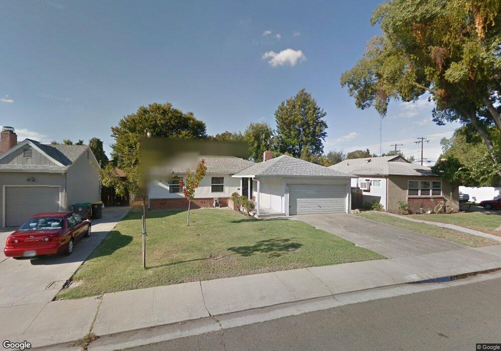
117 W Atlee St Stockton, CA 95204
Midtown NeighborhoodEstimated Value: $275,000 - $353,000
3
Beds
1
Bath
1,014
Sq Ft
$321/Sq Ft
Est. Value
About This Home
This home is located at 117 W Atlee St, Stockton, CA 95204 and is currently estimated at $325,587, approximately $321 per square foot. 117 W Atlee St is a home located in San Joaquin County with nearby schools including Cleveland Elementary School, Wilson Elementary School, and El Dorado Elementary School.
Ownership History
Date
Name
Owned For
Owner Type
Purchase Details
Closed on
Jan 7, 2013
Sold by
Tirapelle Orlando and Orlando Tirapelle
Bought by
Tirapelle Holdings Llc
Current Estimated Value
Purchase Details
Closed on
Jan 7, 2012
Sold by
Tirapelle Orlando and Orlando Tirapelle
Bought by
Tirapelle Holdings Llc
Purchase Details
Closed on
Jun 27, 2003
Sold by
Tirapelle Orlando and Tirapelle Josephine
Bought by
Tirapelle Orlando and Tirapelle Josephine
Create a Home Valuation Report for This Property
The Home Valuation Report is an in-depth analysis detailing your home's value as well as a comparison with similar homes in the area
Home Values in the Area
Average Home Value in this Area
Purchase History
| Date | Buyer | Sale Price | Title Company |
|---|---|---|---|
| Tirapelle Holdings Llc | -- | None Available | |
| Tirapelle Holdings Llc | -- | None Available | |
| Tirapelle Orlando | -- | None Available | |
| Tirapelle Orlando | -- | -- |
Source: Public Records
Tax History Compared to Growth
Tax History
| Year | Tax Paid | Tax Assessment Tax Assessment Total Assessment is a certain percentage of the fair market value that is determined by local assessors to be the total taxable value of land and additions on the property. | Land | Improvement |
|---|---|---|---|---|
| 2025 | $801 | $60,192 | $17,419 | $42,773 |
| 2024 | $787 | $59,013 | $17,078 | $41,935 |
| 2023 | $770 | $57,857 | $16,744 | $41,113 |
| 2022 | $731 | $56,723 | $16,416 | $40,307 |
| 2021 | $702 | $55,612 | $16,095 | $39,517 |
| 2020 | $715 | $55,042 | $15,930 | $39,112 |
| 2019 | $713 | $53,964 | $15,618 | $38,346 |
| 2018 | $700 | $52,907 | $15,312 | $37,595 |
| 2017 | $663 | $51,870 | $15,012 | $36,858 |
| 2016 | $675 | $50,853 | $14,718 | $36,135 |
| 2014 | $644 | $49,108 | $14,213 | $34,895 |
Source: Public Records
Map
Nearby Homes
- 51 W Barrymore St
- 78 W Downs St
- 95 W Downs St
- 217 W Essex St
- 190 W Mckenzie Ave
- 40 E Atlee St
- 328 Northbank Ct Unit 32
- 320 W Bianchi Rd
- 105 W Euclid Ave
- 4332 Pacific Ave Unit 42
- 4332 Pacific Ave Unit 65
- 4332 Pacific Ave Unit 38
- 4401 Bidwell Place
- 270 E Downs St
- 235 E Knoles Way
- 3427 N Hunter St
- 222 Carson Place
- 283 E Churchill St
- 228 Carson Place
- 760 Podesto Rd
- 125 W Atlee St
- 109 W Atlee St
- 118 W Barrymore St
- 133 W Atlee St
- 110 W Barrymore St
- 126 W Barrymore St
- 101 W Atlee St Unit 7
- 134 W Barrymore St
- 3931 N Commerce St
- 126 W Atlee St Unit 7
- 110 W Atlee St
- 141 W Atlee St
- 134 W Atlee St
- 102 W Atlee St
- 142 W Barrymore St
- 142 W Atlee St
- 149 W Atlee St
- 117 W Barrymore St
- 117 W Mckenzie Ave
- 150 W Barrymore St