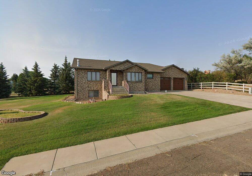
1177 10th St E Dickinson, ND 58601
Estimated Value: $512,000 - $651,860
2
Beds
5
Baths
1,898
Sq Ft
$312/Sq Ft
Est. Value
About This Home
This home is located at 1177 10th St E, Dickinson, ND 58601 and is currently estimated at $591,953, approximately $311 per square foot. 1177 10th St E is a home located in Stark County with nearby schools including Trinity Catholic Schools and Trinity Elementary School East.
Ownership History
Date
Name
Owned For
Owner Type
Purchase Details
Closed on
May 15, 2020
Sold by
Cdb Construction Inc
Bought by
Neville West and Neville Rachel
Current Estimated Value
Home Financials for this Owner
Home Financials are based on the most recent Mortgage that was taken out on this home.
Original Mortgage
$398,311
Outstanding Balance
$349,069
Interest Rate
3.3%
Mortgage Type
New Conventional
Estimated Equity
$242,884
Purchase Details
Closed on
Aug 12, 2019
Sold by
Sahr Thomas D and Johnson Sahr Jawayne
Bought by
Neville West Cozzens and Neville Rachel Lynn
Create a Home Valuation Report for This Property
The Home Valuation Report is an in-depth analysis detailing your home's value as well as a comparison with similar homes in the area
Home Values in the Area
Average Home Value in this Area
Purchase History
| Date | Buyer | Sale Price | Title Company |
|---|---|---|---|
| Neville West | $474,180 | North Dakota Guaranty & Ttl | |
| Neville West Cozzens | $60,000 | None Available |
Source: Public Records
Mortgage History
| Date | Status | Borrower | Loan Amount |
|---|---|---|---|
| Open | Neville West | $398,311 |
Source: Public Records
Tax History
| Year | Tax Paid | Tax Assessment Tax Assessment Total Assessment is a certain percentage of the fair market value that is determined by local assessors to be the total taxable value of land and additions on the property. | Land | Improvement |
|---|---|---|---|---|
| 2025 | $5,061 | $524,500 | $57,600 | $466,900 |
| 2024 | $6,220 | $524,500 | $57,600 | $466,900 |
| 2023 | $5,174 | $524,500 | $57,600 | $466,900 |
| 2022 | $4,910 | $246,750 | $0 | $0 |
| 2021 | $4,734 | $460,200 | $57,600 | $402,600 |
| 2020 | $1,217 | $140,500 | $46,100 | $94,400 |
| 2019 | $160 | $140,500 | $46,100 | $94,400 |
| 2017 | $1,675 | $153,200 | $46,100 | $107,100 |
| 2015 | $1,675 | $191,300 | $47,800 | $143,500 |
| 2014 | $1,713 | $181,100 | $47,800 | $133,300 |
| 2013 | -- | $170,400 | $47,800 | $122,600 |
Source: Public Records
Map
Nearby Homes
- 1163 11th St E
- 1111 Alexander Dr
- 1126 11th Ave E
- 1132 Alexander Dr
- 1129 Alexander Dr
- 1148 11th Ave E
- 1147 Alexander Dr
- 1148 Alexander Dr
- 1160 Alexander Dr
- 1168 11th Ave E
- 1169 11th Ave E
- 1192 11th Ave E
- 1080 12th St E
- 1118 12th St E
- 1189 Alexander Dr
- 1126 10th St E
- 1150 12th St E
- 1162 12th St E
- 1127 Hoover St
- 1054 12th St E
Your Personal Tour Guide
Ask me questions while you tour the home.