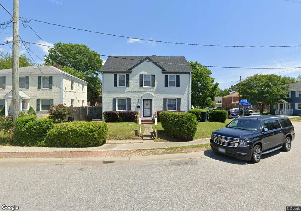
118 Burns St Hampton, VA 23669
Newtown-Crown Point NeighborhoodEstimated Value: $252,000 - $270,816
4
Beds
2
Baths
1,584
Sq Ft
$165/Sq Ft
Est. Value
About This Home
This home is located at 118 Burns St, Hampton, VA 23669 and is currently estimated at $260,954, approximately $164 per square foot. 118 Burns St is a home located in Hampton City with nearby schools including Hunter B. Andrews PK-8 School, C. Alton Lindsay Middle School, and Phoebus High School.
Ownership History
Date
Name
Owned For
Owner Type
Purchase Details
Closed on
Jul 17, 2014
Sold by
Breland Cumbo Trustee Constance L
Bought by
Baker Eugune A
Current Estimated Value
Home Financials for this Owner
Home Financials are based on the most recent Mortgage that was taken out on this home.
Original Mortgage
$138,008
Outstanding Balance
$106,444
Interest Rate
4.5%
Mortgage Type
FHA
Estimated Equity
$154,510
Create a Home Valuation Report for This Property
The Home Valuation Report is an in-depth analysis detailing your home's value as well as a comparison with similar homes in the area
Home Values in the Area
Average Home Value in this Area
Purchase History
| Date | Buyer | Sale Price | Title Company |
|---|---|---|---|
| Baker Eugune A | $107,000 | -- |
Source: Public Records
Mortgage History
| Date | Status | Borrower | Loan Amount |
|---|---|---|---|
| Open | Baker Eugune A | $138,008 |
Source: Public Records
Tax History Compared to Growth
Tax History
| Year | Tax Paid | Tax Assessment Tax Assessment Total Assessment is a certain percentage of the fair market value that is determined by local assessors to be the total taxable value of land and additions on the property. | Land | Improvement |
|---|---|---|---|---|
| 2025 | $2,477 | $240,400 | $50,000 | $190,400 |
| 2024 | $2,477 | $215,400 | $50,000 | $165,400 |
| 2023 | $2,123 | $183,000 | $48,000 | $135,000 |
| 2022 | $2,005 | $169,900 | $42,000 | $127,900 |
| 2021 | $1,893 | $142,200 | $37,500 | $104,700 |
| 2020 | $1,669 | $134,600 | $37,500 | $97,100 |
| 2019 | $1,632 | $131,600 | $37,500 | $94,100 |
| 2018 | $1,787 | $131,400 | $37,500 | $93,900 |
| 2017 | $1,723 | $0 | $0 | $0 |
| 2016 | $1,723 | $131,400 | $0 | $0 |
| 2015 | $1,690 | $0 | $0 | $0 |
| 2014 | $1,623 | $115,700 | $37,500 | $78,200 |
Source: Public Records
Map
Nearby Homes
- 106 Clyde St
- 117 Barksdale Rd
- 4006 Monitor Dr
- 4017 Buchanan Dr
- 3749 Chesapeake Ave
- 15 Elizabeth Rd
- 7 Elizabeth Rd
- 17 Somerset Ln
- 29 Moss Ave
- 3611 Matoaka Rd
- 116 Ivy Home Rd
- 15 Victor St
- 126 Cherokee Rd
- 4204 Kecoughtan Rd
- 131 Cherokee Rd
- 326 Brightwood Ave
- 15 Henry St
- 32 W Sunset Rd
- 3300 Kecoughtan Rd
- 3822 Victoria Blvd