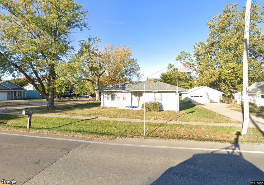
118 Grant St N Bondurant, IA 50035
Estimated Value: $195,015 - $244,000
3
Beds
1
Bath
1,056
Sq Ft
$202/Sq Ft
Est. Value
About This Home
This home is located at 118 Grant St N, Bondurant, IA 50035 and is currently estimated at $213,004, approximately $201 per square foot. 118 Grant St N is a home located in Polk County with nearby schools including Anderson Elementary School, Morris Elementary School, and Bondurant - Farrar Middle School.
Ownership History
Date
Name
Owned For
Owner Type
Purchase Details
Closed on
Nov 15, 1998
Sold by
Johnston Connie S and Lay Connie S
Bought by
Green Dennis D and Green Darla S
Current Estimated Value
Home Financials for this Owner
Home Financials are based on the most recent Mortgage that was taken out on this home.
Original Mortgage
$61,968
Outstanding Balance
$13,526
Interest Rate
6.59%
Mortgage Type
FHA
Estimated Equity
$199,478
Create a Home Valuation Report for This Property
The Home Valuation Report is an in-depth analysis detailing your home's value as well as a comparison with similar homes in the area
Home Values in the Area
Average Home Value in this Area
Purchase History
| Date | Buyer | Sale Price | Title Company |
|---|---|---|---|
| Green Dennis D | $61,500 | -- |
Source: Public Records
Mortgage History
| Date | Status | Borrower | Loan Amount |
|---|---|---|---|
| Open | Green Dennis D | $61,968 |
Source: Public Records
Tax History Compared to Growth
Tax History
| Year | Tax Paid | Tax Assessment Tax Assessment Total Assessment is a certain percentage of the fair market value that is determined by local assessors to be the total taxable value of land and additions on the property. | Land | Improvement |
|---|---|---|---|---|
| 2025 | $2,630 | $167,200 | $54,200 | $113,000 |
| 2024 | $2,630 | $157,200 | $50,200 | $107,000 |
| 2023 | $2,650 | $157,200 | $50,200 | $107,000 |
| 2022 | $2,634 | $132,300 | $43,000 | $89,300 |
| 2021 | $2,714 | $132,300 | $43,000 | $89,300 |
| 2020 | $2,680 | $123,800 | $40,200 | $83,600 |
| 2019 | $2,268 | $123,800 | $40,200 | $83,600 |
| 2018 | $2,220 | $98,300 | $34,800 | $63,500 |
| 2017 | $2,012 | $98,300 | $34,800 | $63,500 |
| 2016 | $1,964 | $87,700 | $30,700 | $57,000 |
| 2015 | $1,964 | $87,700 | $30,700 | $57,000 |
| 2014 | $1,868 | $86,500 | $29,800 | $56,700 |
Source: Public Records
Map
Nearby Homes
- 112 Blaine St NW
- 00 2nd St NW
- 713 4th St NW
- 1612 Summit Cir NE
- 1601 Summit Cir NE
- 1713 Summit Cir NE
- 1609 Summit Cir NE
- 1705 Summit Cir NE
- 904 Campus Ct NE
- 1701 Summit Cir NE
- 1605 Summit Cir NE
- 1709 Summit Cir NE
- 800 9th Ct SE
- 505 Cleveland Ave SE
- 509 Fireside Dr NW
- LT 6 Ja-Mar Village
- 901 8th St NW
- 905 8th St NW
- 909 8th St NW
- 913 8th St NW