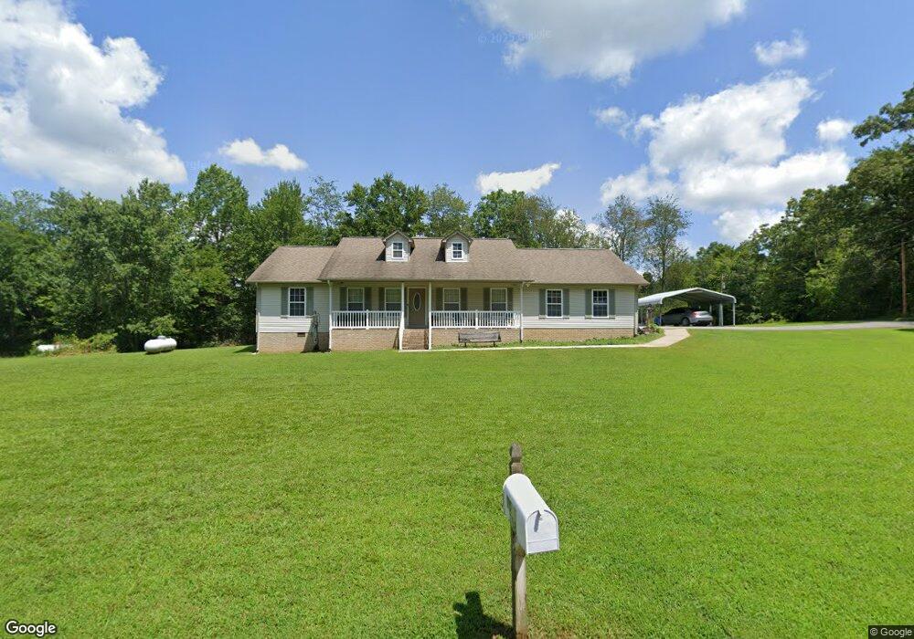
118 Kendra Rd Clarkrange, TN 38553
Estimated Value: $295,498 - $404,000
Studio
2
Baths
2,316
Sq Ft
$147/Sq Ft
Est. Value
About This Home
This home is located at 118 Kendra Rd, Clarkrange, TN 38553 and is currently estimated at $341,375, approximately $147 per square foot. 118 Kendra Rd is a home located in Fentress County.
Ownership History
Date
Name
Owned For
Owner Type
Purchase Details
Closed on
Jul 16, 2025
Sold by
Jean Todd
Bought by
Rector David
Current Estimated Value
Purchase Details
Closed on
Mar 13, 2020
Sold by
Lindsay Kimberly Renee Todd
Bought by
Todd Melinda Jean
Purchase Details
Closed on
Mar 4, 2019
Sold by
Allen Todd Jr Robert and Todd Nicholas Adam
Bought by
Todd Melinda Jean and Todd Kimberly Renee
Purchase Details
Closed on
Sep 3, 2008
Sold by
Todd Robert
Bought by
Todd Nicholas Adam
Purchase Details
Closed on
Aug 8, 2008
Bought by
Todd Robert and Todd Patricia
Purchase Details
Closed on
Aug 28, 2007
Bought by
Ledbetter Elmer and Ledbetter Debra
Purchase Details
Closed on
Jun 10, 2005
Sold by
Not Provided
Bought by
Todd Nicholas A
Purchase Details
Closed on
Sep 20, 2001
Bought by
Linder Eddie J
Create a Home Valuation Report for This Property
The Home Valuation Report is an in-depth analysis detailing your home's value as well as a comparison with similar homes in the area
Purchase History
We collect this data history from publicly available records. To have your information removed, we recommend requesting removal directly through your county’s website.
| Date | Buyer | Sale Price | Title Company |
|---|---|---|---|
| Rector David | -- | None Listed On Document | |
| Todd Melinda Jean | -- | -- | |
| Todd Melinda Jean | -- | None Listed On Document | |
| Todd Melinda Jean | -- | None Available | |
| Todd Nicholas Adam | -- | -- | |
| Todd Robert | $162,200 | -- | |
| Ledbetter Elmer | $10,000 | -- | |
| Todd Nicholas A | $6,000 | -- | |
| Linder Eddie J | $119,000 | -- |
Source: Public Records
Tax History
| Year | Tax Paid | Tax Assessment Tax Assessment Total Assessment is a certain percentage of the fair market value that is determined by local assessors to be the total taxable value of land and additions on the property. | Land | Improvement |
|---|---|---|---|---|
| 2025 | $899 | $66,600 | $4,325 | $62,275 |
| 2024 | $899 | $66,600 | $4,325 | $62,275 |
| 2023 | $899 | $66,600 | $4,325 | $62,275 |
| 2022 | $758 | $39,700 | $2,550 | $37,150 |
| 2021 | $758 | $39,700 | $2,550 | $37,150 |
| 2020 | $758 | $39,700 | $2,550 | $37,150 |
| 2019 | $758 | $39,700 | $2,550 | $37,150 |
| 2018 | $758 | $39,700 | $2,550 | $37,150 |
| 2017 | $747 | $37,650 | $2,275 | $35,375 |
| 2016 | $747 | $37,650 | $2,275 | $35,375 |
| 2015 | $747 | $37,665 | $0 | $0 |
| 2014 | $747 | $37,665 | $0 | $0 |
Source: Public Records
Map
Nearby Homes
- 6604 S York Hwy
- 0 Old Martha Washington Rd
- 6940 S York Hwy
- 2047 Todd Rd
- 1188 Clarkrange Monterey Hwy
- 2019 Martha Washington Rd
- 515 Ferry Bend Trail Unit 18
- 515 Ferry Bend Trail
- 469 Ferry Bend Trail
- 122 Green Acres
- 106 MacA Ridge Cir
- 104 Green Acres
- 3695 Martha Washington Rd
- 205 Ferry Bend Trail
- 145 Rhum Rd
- 1259 Franklin Loop
- 1243 Franklin Loop
- 6006 S York Hwy
Your Personal Tour Guide
Ask me questions while you tour the home.