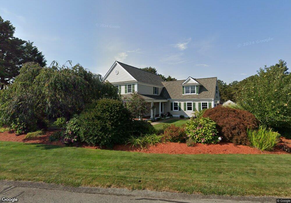
118 Polaris Dr Mashpee, MA 02649
Estimated Value: $1,247,000 - $1,314,000
3
Beds
3
Baths
3,216
Sq Ft
$400/Sq Ft
Est. Value
About This Home
This home is located at 118 Polaris Dr, Mashpee, MA 02649 and is currently estimated at $1,284,814, approximately $399 per square foot. 118 Polaris Dr is a home located in Barnstable County with nearby schools including Kenneth C. Coombs School, Quashnet School, and Mashpee Middle School.
Ownership History
Date
Name
Owned For
Owner Type
Purchase Details
Closed on
Jan 28, 2020
Sold by
118 Polaris Drive Ret
Bought by
Lauren M Walsh T 2020
Current Estimated Value
Purchase Details
Closed on
May 17, 2011
Sold by
Brown Peter H and Brown Pamela D
Bought by
118 Polaris Drive Re T
Home Financials for this Owner
Home Financials are based on the most recent Mortgage that was taken out on this home.
Original Mortgage
$500,000
Interest Rate
3%
Mortgage Type
Purchase Money Mortgage
Purchase Details
Closed on
Feb 2, 2004
Sold by
Willis Geoffrey A and Willis Janet L
Bought by
Brown Peter H and Brown Pamela D
Home Financials for this Owner
Home Financials are based on the most recent Mortgage that was taken out on this home.
Original Mortgage
$240,000
Interest Rate
5.82%
Mortgage Type
Purchase Money Mortgage
Create a Home Valuation Report for This Property
The Home Valuation Report is an in-depth analysis detailing your home's value as well as a comparison with similar homes in the area
Home Values in the Area
Average Home Value in this Area
Purchase History
| Date | Buyer | Sale Price | Title Company |
|---|---|---|---|
| Lauren M Walsh T 2020 | -- | None Available | |
| 118 Polaris Drive Re T | $627,500 | -- | |
| Brown Peter H | $729,000 | -- |
Source: Public Records
Mortgage History
| Date | Status | Borrower | Loan Amount |
|---|---|---|---|
| Previous Owner | 118 Polaris Drive Re T | $500,000 | |
| Previous Owner | Brown Peter H | $303,500 | |
| Previous Owner | Brown Peter H | $240,000 | |
| Previous Owner | Brown Peter H | $150,000 |
Source: Public Records
Tax History Compared to Growth
Tax History
| Year | Tax Paid | Tax Assessment Tax Assessment Total Assessment is a certain percentage of the fair market value that is determined by local assessors to be the total taxable value of land and additions on the property. | Land | Improvement |
|---|---|---|---|---|
| 2025 | $7,935 | $1,198,700 | $235,100 | $963,600 |
| 2024 | $7,468 | $1,161,400 | $231,600 | $929,800 |
| 2023 | $6,938 | $989,800 | $220,500 | $769,300 |
| 2022 | $6,815 | $834,100 | $193,100 | $641,000 |
| 2021 | $6,763 | $745,600 | $180,100 | $565,500 |
| 2020 | $6,590 | $725,000 | $173,200 | $551,800 |
| 2019 | $6,274 | $693,300 | $173,200 | $520,100 |
| 2018 | $6,157 | $690,300 | $173,200 | $517,100 |
| 2017 | $6,246 | $679,700 | $173,200 | $506,500 |
| 2016 | $6,012 | $650,600 | $173,200 | $477,400 |
| 2015 | $5,755 | $631,700 | $173,200 | $458,500 |
| 2014 | $5,197 | $553,500 | $170,500 | $383,000 |
Source: Public Records
Map
Nearby Homes
- 10 Shadbush Cir
- 8 Shadbush Cir
- 109 Great Pines Dr
- 7 Sandy Way
- 20 Sandy Way
- 41 Great Pines Dr
- 247 Great Pines Dr
- 89 Degrass Rd
- 17 Degrass Rd
- 29 Carl Landi Cir
- 61 Wintergreen Rd
- 55 Blue Castle Dr
- 240 Surf Dr
- 1 Beech Plum Dr
- 84 Overlook Cir
- 6 Heron Way
- 22 & 26 Oyster Way
- 9 North Way
- T 131 Shellback Way Unit 131
- 26 Oyster Way