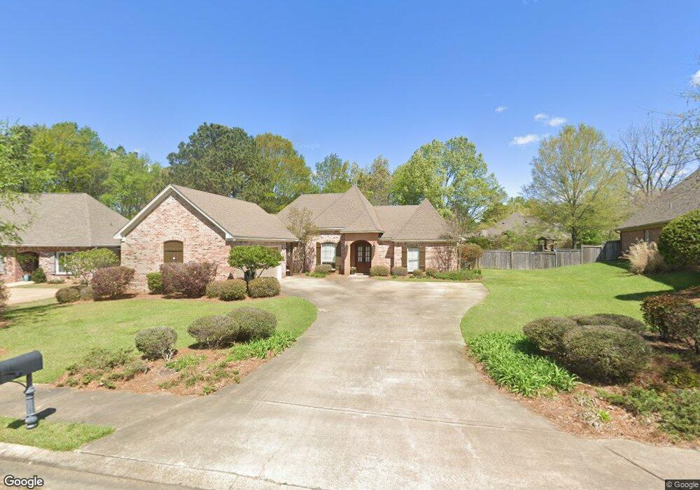
1184 Windrose Cir Madison, MS 39110
Estimated Value: $401,000 - $436,000
4
Beds
3
Baths
2,657
Sq Ft
$160/Sq Ft
Est. Value
About This Home
This home is located at 1184 Windrose Cir, Madison, MS 39110 and is currently estimated at $425,562, approximately $160 per square foot. 1184 Windrose Cir is a home located in Madison County with nearby schools including Madison Avenue Upper Elementary School, Madison Avenue Elementary, and Madison Middle School.
Ownership History
Date
Name
Owned For
Owner Type
Purchase Details
Closed on
Nov 17, 2010
Sold by
Secretary Of Housing & Urban Development
Bought by
Traxler John Kendall and Traxler Lynda L
Current Estimated Value
Home Financials for this Owner
Home Financials are based on the most recent Mortgage that was taken out on this home.
Original Mortgage
$237,350
Outstanding Balance
$157,024
Interest Rate
4.4%
Mortgage Type
FHA
Estimated Equity
$268,538
Purchase Details
Closed on
May 14, 2010
Sold by
Trustmark National Bank
Bought by
Secretary Of Housing & Urban Development
Purchase Details
Closed on
May 13, 2010
Sold by
Gandy Dale Alan and Gandy Lydia K
Bought by
Trustmark National Bank
Create a Home Valuation Report for This Property
The Home Valuation Report is an in-depth analysis detailing your home's value as well as a comparison with similar homes in the area
Home Values in the Area
Average Home Value in this Area
Purchase History
| Date | Buyer | Sale Price | Title Company |
|---|---|---|---|
| Traxler John Kendall | -- | Luckett Land Title Inc | |
| Secretary Of Housing & Urban Development | -- | None Available | |
| Trustmark National Bank | $309,441 | None Available |
Source: Public Records
Mortgage History
| Date | Status | Borrower | Loan Amount |
|---|---|---|---|
| Open | Traxler John Kendall | $237,350 |
Source: Public Records
Tax History
| Year | Tax Paid | Tax Assessment Tax Assessment Total Assessment is a certain percentage of the fair market value that is determined by local assessors to be the total taxable value of land and additions on the property. | Land | Improvement |
|---|---|---|---|---|
| 2025 | $3,056 | $28,796 | $0 | $0 |
| 2024 | $3,056 | $28,796 | $0 | $0 |
| 2023 | $3,056 | $28,796 | $0 | $0 |
| 2022 | $3,056 | $28,796 | $0 | $0 |
| 2021 | $2,921 | $27,639 | $0 | $0 |
| 2020 | $2,921 | $27,639 | $0 | $0 |
| 2019 | $2,921 | $27,639 | $0 | $0 |
| 2018 | $2,921 | $27,639 | $0 | $0 |
| 2017 | $2,867 | $27,176 | $0 | $0 |
| 2016 | $2,867 | $27,176 | $0 | $0 |
| 2015 | $2,867 | $27,176 | $0 | $0 |
| 2014 | $3,064 | $28,868 | $0 | $0 |
Source: Public Records
Map
Nearby Homes
- 1205 Woodberry Dr
- 1241 Woodberry Dr
- 129 Victoria Place
- 105 Victoria Place
- 169 Saint Ives Dr
- 290 Geneva Blvd
- 1616 Baywood Dr
- 722 Arlington Ct
- 1133 Highway 51
- 216 Woodland Brook Dr
- 109 Brisage Dr
- 717 Wildberry Pointe
- 422 Summerville Dr
- 325 Mockingbird Ln
- 418 Wildwood Pointe
- 106 Normandy Ct
- 138 Oakmont Dr
- 628 Boxwood Place
- 235 Hawthorne Dr
- 202 Saint Pierre Cove
- 1188 Windrose Cir
- 1180 Windrose Cir
- 101 Windrose Cir
- 1133 Windrose Cir Unit 392
- 812 Wellington Way
- 1176 Windrose Cir
- 1185 Windrose Cir
- 808 Wellington Way
- 1175 Windrose Cir
- 1101 Windrose Cir
- 157 Woodsong Way
- 153 Woodsong Way
- 1191 Windrose Cir
- 804 Wellington Way
- 161 Woodsong Way
- 1172 Windrose Cir
- 1169 Windrose Cir
- 800 Wellington Way
- 1000 Laramie Ct
- 165 Woodsong Way