Estimated Value: $131,527 - $366,000
Studio
1
Bath
1,288
Sq Ft
$191/Sq Ft
Est. Value
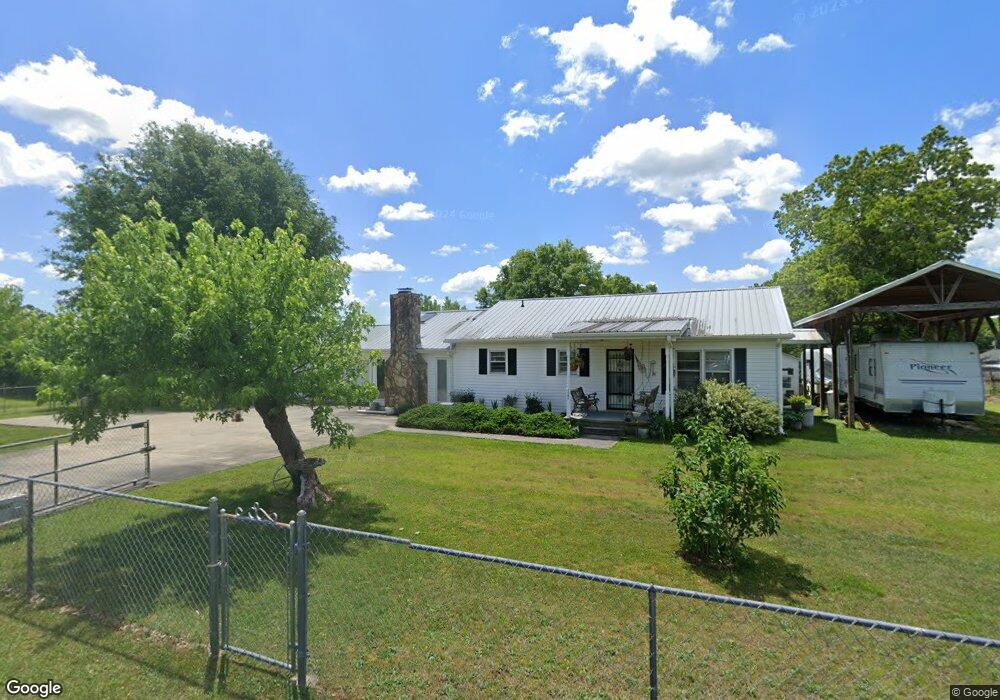
About This Home
This home is located at 1187 Hildabrand Rd, Ocoee, TN 37361 and is currently estimated at $246,632, approximately $191 per square foot. 1187 Hildabrand Rd is a home located in Polk County.
Ownership History
Date
Name
Owned For
Owner Type
Purchase Details
Closed on
May 15, 2020
Sold by
Sluder Leonard C and Sluder Karon
Bought by
Bunn Jennifer Kathleen and Sluder Chrissy Nadine
Current Estimated Value
Purchase Details
Closed on
Jun 19, 1992
Bought by
Sluder Leonard C
Purchase Details
Closed on
Apr 13, 1992
Bought by
Home Bank The Of Tennessee
Purchase Details
Closed on
Jul 15, 1987
Bought by
Adams Joseph F and Adams Bonnie R
Purchase Details
Closed on
Jul 19, 1975
Create a Home Valuation Report for This Property
The Home Valuation Report is an in-depth analysis detailing your home's value as well as a comparison with similar homes in the area
Purchase History
| Date | Buyer | Sale Price | Title Company |
|---|---|---|---|
| Bunn Jennifer Kathleen | -- | None Available | |
| Sluder Leonard C | $30,000 | -- | |
| Home Bank The Of Tennessee | -- | -- | |
| Adams Joseph F | -- | -- | |
| -- | -- | -- |
Source: Public Records
Tax History
| Year | Tax Paid | Tax Assessment Tax Assessment Total Assessment is a certain percentage of the fair market value that is determined by local assessors to be the total taxable value of land and additions on the property. | Land | Improvement |
|---|---|---|---|---|
| 2025 | $508 | $30,075 | $3,450 | $26,625 |
| 2024 | $508 | $30,075 | $3,450 | $26,625 |
| 2023 | $508 | $30,075 | $0 | $0 |
| 2022 | $474 | $18,850 | $2,475 | $16,375 |
| 2021 | $474 | $18,850 | $2,475 | $16,375 |
| 2020 | $474 | $18,850 | $2,475 | $16,375 |
| 2019 | $474 | $18,850 | $2,475 | $16,375 |
| 2018 | $474 | $18,850 | $2,475 | $16,375 |
| 2017 | $417 | $16,550 | $2,225 | $14,325 |
| 2016 | $377 | $15,675 | $2,225 | $13,450 |
| 2015 | $377 | $15,675 | $2,225 | $13,450 |
| 2014 | $377 | $15,690 | $0 | $0 |
Source: Public Records
Map
Nearby Homes
- 377 Reynolds Bridge Rd
- 4515 Highway 411
- Lot 18 Crews Dr
- 176 Rivers Edge Ln
- 0 U S Highway 64
- 2151 Old Federal Rd
- 3971 Highway 411
- 435 Hildabrand Rd
- 1250 Welcome Valley Rd
- 130 Stump St
- 1903 Old Federal Rd
- 0 Chestuee Rd NE Unit 1527633
- 0 Old Federal Rd Unit RTC3098994
- 122 Crossing Way
- 10 Dakota Dr NE
- 509 Chestuee Rd NE
- Lot 10 Dakota Dr NE
- 0 Ocoee River Landing Dr Unit 20252171
- 1685 Welcome Valley Rd
- 156 Chestuee Ln NE
- 600 Reynolds Bridge Rd
- 614 Reynolds Bridge Rd
- 560 Reynolds Bridge Rd
- 584 Reynolds Bridge Rd
- 614 Reynolds Bridge Rd
- 624 Reynolds Bridge Rd
- 577 Reynolds Bridge Rd
- 559 Reynolds Bridge Rd
- 1118 Hildabrand Rd
- 00 Reynolds Bridge Rd
- 520 Reynolds Bridge Rd
- 1150 Hildabrand Rd
- 1084 Hildabrand Rd
- 1098 Hildabrand Rd
- 434 York Rd
- 398 York Rd
- 475 Reynolds Bridge Rd
- 475 Reynolds Bridge Rd
- 469 Reynolds Bridge Rd
- 174 Smyrna Rd
Your Personal Tour Guide
Ask me questions while you tour the home.