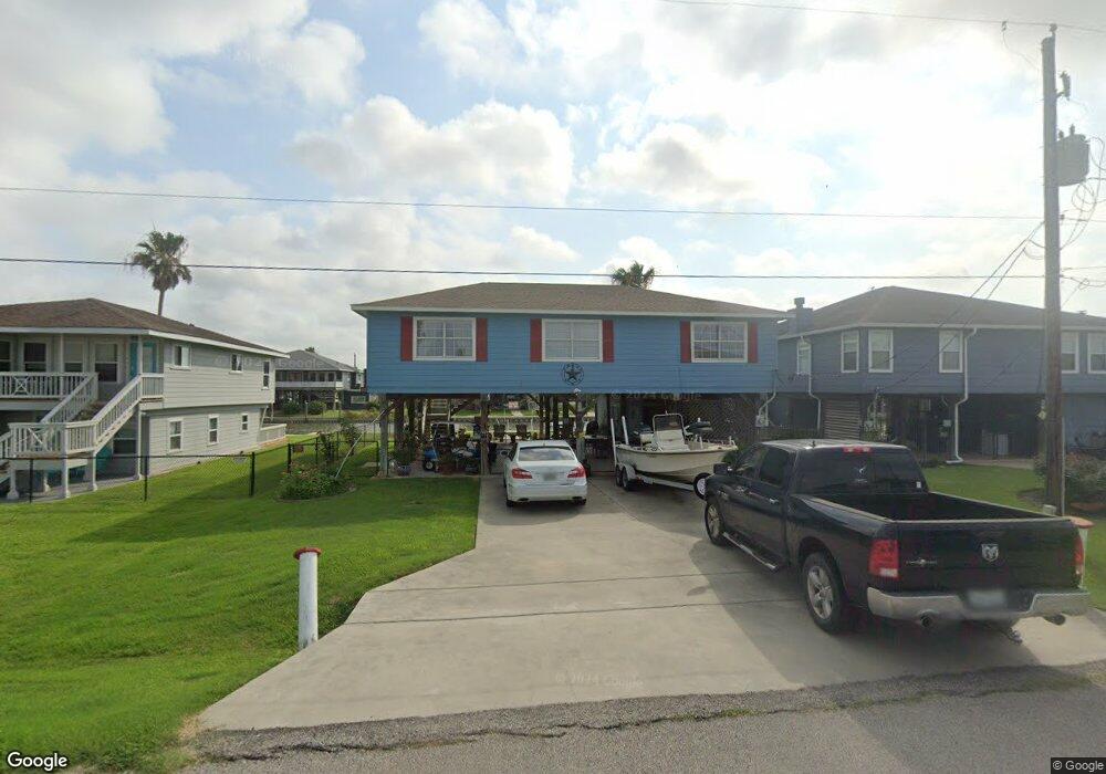
119 Four Master Rd Freeport, TX 77541
Estimated Value: $344,374 - $424,000
3
Beds
2
Baths
1,400
Sq Ft
$279/Sq Ft
Est. Value
About This Home
This home is located at 119 Four Master Rd, Freeport, TX 77541 and is currently estimated at $390,094, approximately $278 per square foot. 119 Four Master Rd is a home located in Brazoria County with nearby schools including Velasco Elementary School, O'Hara Lanier Middle School, and Freeport Intermediate School.
Ownership History
Date
Name
Owned For
Owner Type
Purchase Details
Closed on
Jun 21, 2006
Sold by
The Westcap Corp Of Delaware
Bought by
Branton Claud C and Branton Sandra L
Current Estimated Value
Home Financials for this Owner
Home Financials are based on the most recent Mortgage that was taken out on this home.
Original Mortgage
$176,490
Outstanding Balance
$104,110
Interest Rate
6.63%
Mortgage Type
Purchase Money Mortgage
Estimated Equity
$285,984
Create a Home Valuation Report for This Property
The Home Valuation Report is an in-depth analysis detailing your home's value as well as a comparison with similar homes in the area
Purchase History
| Date | Buyer | Sale Price | Title Company |
|---|---|---|---|
| Branton Claud C | -- | Alamo Title Company 02 |
Source: Public Records
Mortgage History
| Date | Status | Borrower | Loan Amount |
|---|---|---|---|
| Open | Branton Claud C | $176,490 |
Source: Public Records
Tax History
| Year | Tax Paid | Tax Assessment Tax Assessment Total Assessment is a certain percentage of the fair market value that is determined by local assessors to be the total taxable value of land and additions on the property. | Land | Improvement |
|---|---|---|---|---|
| 2025 | $1,774 | $356,330 | $79,030 | $277,300 |
| 2023 | $1,774 | $317,177 | $79,030 | $316,240 |
| 2022 | $5,838 | $288,343 | $79,030 | $291,150 |
| 2021 | $5,744 | $267,990 | $52,370 | $215,620 |
| 2020 | $5,309 | $238,300 | $52,370 | $185,930 |
| 2019 | $5,484 | $236,960 | $44,320 | $192,640 |
| 2018 | $5,425 | $233,000 | $40,290 | $192,710 |
| 2017 | $5,740 | $245,910 | $40,290 | $205,620 |
| 2016 | $5,218 | $248,380 | $40,290 | $208,090 |
| 2015 | $2,901 | $216,350 | $40,290 | $176,060 |
| 2014 | $2,901 | $184,670 | $30,990 | $153,680 |
Source: Public Records
Map
Nearby Homes
- 122 Four Master Rd
- 123 Four Master Rd
- 114 Four Master Rd
- 122 Driftwood Rd
- 119 Crows Nest Rd
- 1571 Blue Water Dr
- 106 Jolly Boat Ln
- 107 Admiral Ln
- 110 Mariner Rd
- 108 Treasure Ln
- 1503 Blue Water Dr
- 154 Poop Deck Ln
- 1682 Blue Water Dr
- 0 Cr 690a
- 518 Marine Way
- 411 Galley Way
- TBD Marine Way
- 310 Marine Way
- 235 Leeward Way
- 1738 Duncan Dr
- 115 Four Master Rd
- 127 Four Master Rd
- 118 Four Master Rd
- 116 Sand Shoals Rd
- 131 Four Master Rd
- 107 Four Master Rd
- 118 Sand Shoals Rd
- 111 Four Master Rd
- 122 Sand Shoals Rd
- 126 Four Master Rd
- 126 Four Master Rd Unit RRD
- 114 Sand Shoals Rd
- 126 Sand Shoals Rd
- 0 Four Master Rd Unit 28406
- 0 Four Master Rd Unit 47425
- 0 Four Master Rd Unit 50094
- 0 Four Master Rd Unit 51181
- 0 Four Master Rd Unit 64740
- 0 Four Master Rd Unit 42264484
- 135 Four Master Rd
Your Personal Tour Guide
Ask me questions while you tour the home.