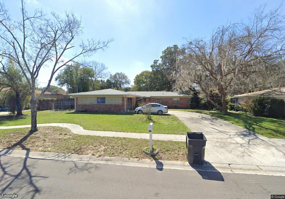
119 Julie Ln Brandon, FL 33511
Estimated Value: $364,427 - $418,000
3
Beds
2
Baths
1,783
Sq Ft
$216/Sq Ft
Est. Value
About This Home
This home is located at 119 Julie Ln, Brandon, FL 33511 and is currently estimated at $385,107, approximately $215 per square foot. 119 Julie Ln is a home located in Hillsborough County with nearby schools including Brooker Elementary School, Burns Middle School, and Bloomingdale High School.
Ownership History
Date
Name
Owned For
Owner Type
Purchase Details
Closed on
Mar 23, 2018
Sold by
Duke Michael A
Bought by
Jones Karen L
Current Estimated Value
Purchase Details
Closed on
Jun 9, 2003
Sold by
Levister Cecil H
Bought by
Levister Cecil H and Jones Karen
Home Financials for this Owner
Home Financials are based on the most recent Mortgage that was taken out on this home.
Original Mortgage
$105,000
Interest Rate
5.16%
Mortgage Type
Unknown
Create a Home Valuation Report for This Property
The Home Valuation Report is an in-depth analysis detailing your home's value as well as a comparison with similar homes in the area
Home Values in the Area
Average Home Value in this Area
Purchase History
| Date | Buyer | Sale Price | Title Company |
|---|---|---|---|
| Jones Karen L | -- | Attorney | |
| Duke Michael A | -- | Attorney | |
| Levister Cecil H | $20,600 | Premier Title Services Inc |
Source: Public Records
Mortgage History
| Date | Status | Borrower | Loan Amount |
|---|---|---|---|
| Previous Owner | Levister Cecil H | $105,000 |
Source: Public Records
Tax History
| Year | Tax Paid | Tax Assessment Tax Assessment Total Assessment is a certain percentage of the fair market value that is determined by local assessors to be the total taxable value of land and additions on the property. | Land | Improvement |
|---|---|---|---|---|
| 2025 | $4,601 | $154,215 | -- | -- |
| 2024 | $4,601 | $149,869 | -- | -- |
| 2023 | $4,515 | $146,459 | $0 | $0 |
| 2022 | $4,355 | $142,193 | $0 | $0 |
| 2021 | $4,319 | $138,051 | $0 | $0 |
| 2020 | $3,565 | $136,145 | $0 | $0 |
| 2019 | $3,482 | $133,084 | $0 | $0 |
| 2018 | $3,601 | $125,403 | $0 | $0 |
| 2017 | $1,945 | $140,803 | $0 | $0 |
| 2016 | $1,117 | $86,102 | $0 | $0 |
| 2015 | $1,127 | $85,503 | $0 | $0 |
| 2014 | $1,103 | $84,824 | $0 | $0 |
| 2013 | -- | $83,570 | $0 | $0 |
Source: Public Records
Map
Nearby Homes
- 124 Barrington Dr
- 133 Barrington Dr
- 142 Barrington Dr
- 527 Julie Ln
- 530 Julie Ln
- 1001 Edgemont Place
- 1409 Bryan Rd
- 101 Kiana Dr
- 832 S Parsons Ave
- 905 Stanberry Dr
- 215 Lake Brook Cir Unit 204
- 606 Bama Rd
- 2456 Knight Island Dr
- 302 Lake Parsons Green Unit 107
- 703 E Lumsden Rd
- 2510 Knight Island Dr
- 1614 Berkshire Dr
- 314 Lake Parsons Green Unit 203
- 602 Hickory Lake Dr
- 2303 Green Lawn St
- 121 Julie Ln
- 117 Julie Ln
- 118 Goldenwood Ave
- 120 Goldenwood Ave
- 123 Julie Ln
- 116 Goldenwood Ave
- 120 Julie Ln
- 118 Julie Ln
- 122 Julie Ln
- 115 Julie Ln
- 122 Goldenwood Ave
- 114 Goldenwood Ave
- 116 Julie Ln
- 124 Julie Ln
- 501 Julie Ln
- 114 Julie Ln
- 112 Goldenwood Ave
- 1401 Lido Dr
- 111 Julie Ln
- 122 Barrington Dr
Your Personal Tour Guide
Ask me questions while you tour the home.