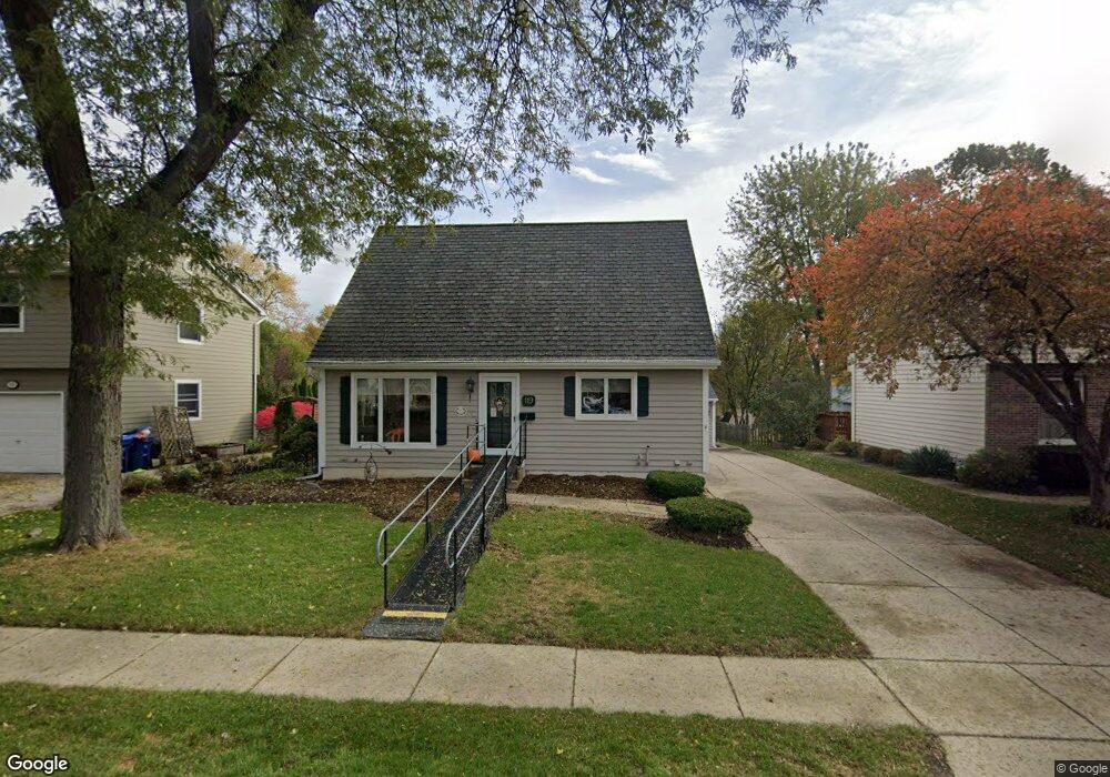
119 Nebraska St Geneva, IL 60134
Northeast Central Geneva NeighborhoodEstimated Value: $419,000 - $486,000
3
Beds
2
Baths
2,159
Sq Ft
$208/Sq Ft
Est. Value
About This Home
This home is located at 119 Nebraska St, Geneva, IL 60134 and is currently estimated at $448,981, approximately $207 per square foot. 119 Nebraska St is a home located in Kane County with nearby schools including Harrison Street Elementary School, Geneva Community High School, and St. Peter School.
Ownership History
Date
Name
Owned For
Owner Type
Purchase Details
Closed on
Mar 11, 2002
Sold by
Swanson Donald W and Swanson Jo Anne F
Bought by
Swanson Jo Ann F
Current Estimated Value
Purchase Details
Closed on
Dec 17, 2001
Sold by
Swanson Jo Anne F
Bought by
Swanson Donald W and Swanson Jo Anne F
Home Financials for this Owner
Home Financials are based on the most recent Mortgage that was taken out on this home.
Original Mortgage
$232,000
Interest Rate
6.92%
Purchase Details
Closed on
Jun 8, 1995
Sold by
Firstar Bank Illinois
Bought by
Swanson Jo Anne F
Create a Home Valuation Report for This Property
The Home Valuation Report is an in-depth analysis detailing your home's value as well as a comparison with similar homes in the area
Home Values in the Area
Average Home Value in this Area
Purchase History
| Date | Buyer | Sale Price | Title Company |
|---|---|---|---|
| Swanson Jo Ann F | -- | -- | |
| Swanson Donald W | -- | First American Title | |
| Swanson Jo Anne F | -- | -- |
Source: Public Records
Mortgage History
| Date | Status | Borrower | Loan Amount |
|---|---|---|---|
| Closed | Swanson Donald W | $232,000 |
Source: Public Records
Tax History Compared to Growth
Tax History
| Year | Tax Paid | Tax Assessment Tax Assessment Total Assessment is a certain percentage of the fair market value that is determined by local assessors to be the total taxable value of land and additions on the property. | Land | Improvement |
|---|---|---|---|---|
| 2024 | $8,022 | $121,424 | $27,964 | $93,460 |
| 2023 | $7,743 | $110,386 | $25,422 | $84,964 |
| 2022 | $7,646 | $102,570 | $23,622 | $78,948 |
| 2021 | $7,401 | $98,758 | $22,744 | $76,014 |
| 2020 | $7,308 | $97,251 | $22,397 | $74,854 |
| 2019 | $7,278 | $95,410 | $21,973 | $73,437 |
| 2018 | $6,732 | $89,190 | $21,973 | $67,217 |
| 2017 | $7,079 | $86,811 | $21,387 | $65,424 |
| 2016 | $6,707 | $81,102 | $21,098 | $60,004 |
| 2015 | -- | $77,108 | $20,059 | $57,049 |
| 2014 | -- | $77,108 | $20,059 | $57,049 |
| 2013 | -- | $85,822 | $20,059 | $65,763 |
Source: Public Records
Map
Nearby Homes
- 228 Crissey Ave
- 501 Dodson St
- Lot 31 Fox Run Dr
- LOT 209 Austin Ave
- 108 S River Ln
- 10 Briar Ln
- 771 Fox Run Dr
- 213 S 5th St
- 315 S 5th St
- 888 Geneva Dr
- 904 Geneva Dr
- 413 Cheever Ave
- 515 Peyton St
- 835 N Bennett St
- 57 S 7th St
- 1226 Lencioni Ct
- 839 N Bennett St
- 1541 Kirkwood Dr
- 221 Campbell Ct
- 246 Kenston Ct Unit 246