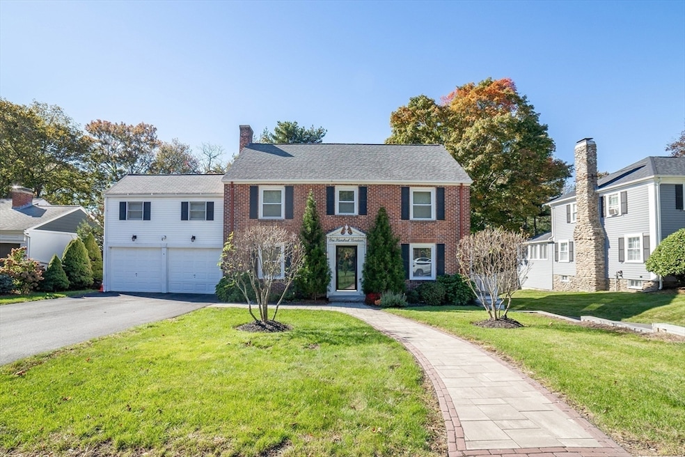
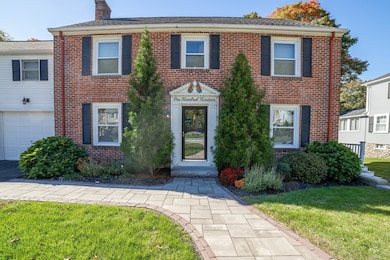
119 Newton Ave N Worcester, MA 01609
Salisbury Street NeighborhoodEstimated payment $5,152/month
Highlights
- Medical Services
- Custom Closet System
- Property is near public transit
- Sauna
- Colonial Architecture
- Wood Flooring
About This Home
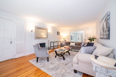
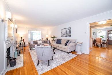
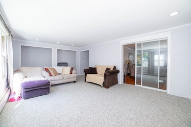
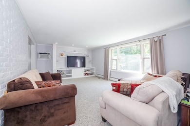
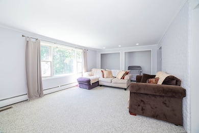
Classic & Stunning describes this 4 Bedroom, 2.5 Bath Brick Center Hall Colonial off Salisbury St, Packed w/Charm & Updates Galore on finished levels PLUS a Fabulous Finished Walk-out Basement! A Spacious Formal Living Room w/Fireplace flows into the Rear Family Room w/Large Picture Window overlooking the yard. The Formal Dining Rm w/Beautiful Custom Built-ins provides tons of storage & a pocket French Door leading to the Updated Kitchen. A 4 Season Sunroom w/walls of windows & Half Bath complete the main level. The 2nd floor offers 2 Bedrooms, a Full Bath, Dedicated Office & Best of All - an AMAZING Primary Bedroom Suite w/Sauna inside the Full Bath plus the Largest Walk-in Closet/Changing Room you may ever see. Head to 3rd fl for another Bedrm + New Bonus Rm w/Built-ins for bedrm/yoga room/office. Check out the Finished Walk-out Basement - Wonderful Party Space/Game Room/Workout Space - a room with many uses! Amenities: Central AC, 2 Driveways, Irrigation System, Gas Heat, etc!
Home Details
Home Type
- Single Family
Est. Annual Taxes
- $8,070
Year Built
- Built in 1940
Lot Details
- 0.26 Acre Lot
- Level Lot
- Property is zoned RS-10
Parking
- 2 Car Attached Garage
- Shared Driveway
- Open Parking
- Off-Street Parking
Home Design
- Colonial Architecture
- Frame Construction
- Shingle Roof
- Rubber Roof
- Concrete Perimeter Foundation
Interior Spaces
- Chair Railings
- Ceiling Fan
- Skylights
- Recessed Lighting
- Insulated Windows
- French Doors
- Sliding Doors
- Insulated Doors
- Living Room with Fireplace
- Home Office
- Bonus Room
- Game Room
- Sun or Florida Room
- Sauna
- Washer and Electric Dryer Hookup
Kitchen
- Range
- Microwave
- Dishwasher
- Stainless Steel Appliances
- Solid Surface Countertops
Flooring
- Wood
- Wall to Wall Carpet
- Ceramic Tile
Bedrooms and Bathrooms
- 4 Bedrooms
- Primary bedroom located on second floor
- Custom Closet System
- Walk-In Closet
- Dressing Area
- Bathtub with Shower
- Separate Shower
Finished Basement
- Walk-Out Basement
- Basement Fills Entire Space Under The House
- Interior Basement Entry
- Block Basement Construction
- Laundry in Basement
Location
- Property is near public transit
- Property is near schools
Utilities
- Central Air
- 2 Cooling Zones
- 5 Heating Zones
- Heating System Uses Natural Gas
- Baseboard Heating
- Heating System Uses Steam
- 200+ Amp Service
- Water Heater
Listing and Financial Details
- Legal Lot and Block 0038A / 006
- Assessor Parcel Number 1800515
Community Details
Overview
- No Home Owners Association
Amenities
- Medical Services
- Shops
Map
Home Values in the Area
Average Home Value in this Area
Tax History
| Year | Tax Paid | Tax Assessment Tax Assessment Total Assessment is a certain percentage of the fair market value that is determined by local assessors to be the total taxable value of land and additions on the property. | Land | Improvement |
|---|---|---|---|---|
| 2025 | $8,070 | $611,800 | $123,500 | $488,300 |
| 2024 | $7,861 | $571,700 | $123,500 | $448,200 |
| 2023 | $7,593 | $529,500 | $106,400 | $423,100 |
| 2022 | $6,989 | $459,500 | $85,100 | $374,400 |
| 2021 | $6,880 | $422,600 | $68,100 | $354,500 |
| 2020 | $6,297 | $370,400 | $68,000 | $302,400 |
| 2019 | $6,392 | $355,100 | $65,500 | $289,600 |
| 2018 | $6,329 | $334,700 | $65,500 | $269,200 |
| 2017 | $6,321 | $328,900 | $65,500 | $263,400 |
| 2016 | $6,523 | $316,500 | $53,700 | $262,800 |
| 2015 | $6,352 | $316,500 | $53,700 | $262,800 |
| 2014 | $6,165 | $315,500 | $53,700 | $261,800 |
Property History
| Date | Event | Price | List to Sale | Price per Sq Ft |
|---|---|---|---|---|
| 10/13/2025 10/13/25 | For Sale | $849,900 | -- | $200 / Sq Ft |
Purchase History
| Date | Type | Sale Price | Title Company |
|---|---|---|---|
| Deed | $363,900 | -- |
Mortgage History
| Date | Status | Loan Amount | Loan Type |
|---|---|---|---|
| Open | $345,700 | Purchase Money Mortgage |
Source: MLS Property Information Network (MLS PIN)
MLS Number: 73442910
APN: WORC-000043-000006-000038A
Disclaimer: Certain information contained herein is derived from information provided by parties other than Homes.com. All information provided is deemed reliable, but is not guaranteed to be accurate and should be independently verified.
![]() The property listing data and information, or the Images, set forth herein were provided to MLS Property Information Network, Inc. from third party sources, including sellers, lessors and public records, and were compiled by MLS Property Information Network, Inc. The property listing data and information, and the Images, are for the personal, non-commercial use of consumers having a good faith interest in purchasing or leasing listed properties of the type displayed to them and may not be used for any purpose other than to identify prospective properties which such consumers may have a good faith interest in purchasing or leasing. MLS Property Information Network, Inc. and its subscribers disclaim any and all representations and warranties as to the accuracy of the property listing data and information, or as to the accuracy of any of the Images, set forth herein.
The property listing data and information, or the Images, set forth herein were provided to MLS Property Information Network, Inc. from third party sources, including sellers, lessors and public records, and were compiled by MLS Property Information Network, Inc. The property listing data and information, and the Images, are for the personal, non-commercial use of consumers having a good faith interest in purchasing or leasing listed properties of the type displayed to them and may not be used for any purpose other than to identify prospective properties which such consumers may have a good faith interest in purchasing or leasing. MLS Property Information Network, Inc. and its subscribers disclaim any and all representations and warranties as to the accuracy of the property listing data and information, or as to the accuracy of any of the Images, set forth herein.
- 30 Beechmont St
- 30 Beechmont St
- 5 Suburban Rd
- 6 Richmond Ave Unit 2
- 24 Lee St Unit 1
- 128 Institute Rd Unit 2
- 174 Park Ave Unit 1
- 284 Highland St Unit 2
- 284 Highland St
- 284 Highland St Unit 3
- 477 Salisbury St
- 44 Dover St Unit 1
- 103 Forest St
- 4 Raleigh Rd Unit 2
- 929 Pleasant St Unit 2
- 42 June St Unit june st
- 15 Rosemont Rd Unit 2
- 20 Somerset St Unit 3
- 11 Schussler Rd Unit 2
- 2 Schussler Rd Unit 1
