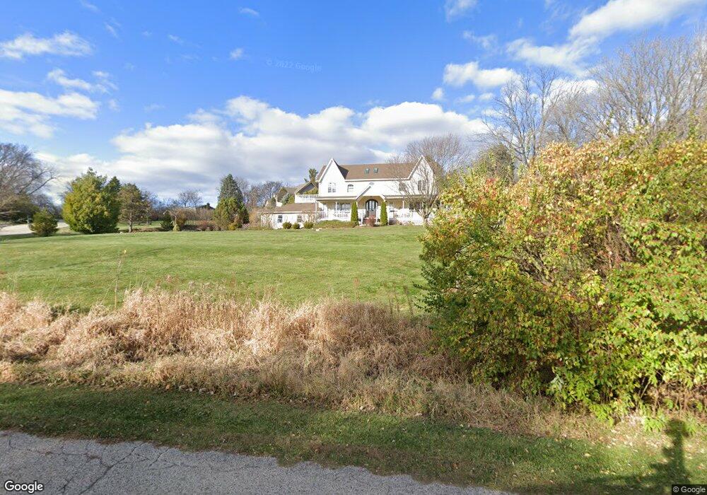
11910 Devonshire St Algonquin, IL 60102
Estimated Value: $393,982 - $470,000
4
Beds
3
Baths
2,907
Sq Ft
$153/Sq Ft
Est. Value
About This Home
This home is located at 11910 Devonshire St, Algonquin, IL 60102 and is currently estimated at $443,746, approximately $152 per square foot. 11910 Devonshire St is a home located in McHenry County with nearby schools including Westfield Community School, Kenneth E Neubert Elementary School, and Harry D Jacobs High School.
Ownership History
Date
Name
Owned For
Owner Type
Purchase Details
Closed on
Apr 5, 2022
Sold by
Johnson William V and Johnson Clarenda
Bought by
Johnson Family Trust
Current Estimated Value
Create a Home Valuation Report for This Property
The Home Valuation Report is an in-depth analysis detailing your home's value as well as a comparison with similar homes in the area
Purchase History
| Date | Buyer | Sale Price | Title Company |
|---|---|---|---|
| Johnson Family Trust | -- | Zanck Coen Wrigh & Saladin Pc |
Source: Public Records
Tax History
| Year | Tax Paid | Tax Assessment Tax Assessment Total Assessment is a certain percentage of the fair market value that is determined by local assessors to be the total taxable value of land and additions on the property. | Land | Improvement |
|---|---|---|---|---|
| 2024 | $8,195 | $127,698 | $23,568 | $104,130 |
| 2023 | $7,704 | $114,210 | $21,079 | $93,131 |
| 2022 | $12,060 | $161,166 | $26,839 | $134,327 |
| 2021 | $11,560 | $150,146 | $25,004 | $125,142 |
| 2020 | $11,253 | $144,831 | $24,119 | $120,712 |
| 2019 | $10,991 | $138,621 | $23,085 | $115,536 |
| 2018 | $10,706 | $130,713 | $21,326 | $109,387 |
| 2017 | $10,470 | $123,139 | $20,090 | $103,049 |
| 2016 | $10,302 | $115,494 | $18,843 | $96,651 |
| 2013 | -- | $100,088 | $17,578 | $82,510 |
Source: Public Records
Map
Nearby Homes
- SWC Talaga and Algonquin Rd
- 1105 Spring Hill Dr
- 1002 Interloch Ct Unit 152
- 308 Rustic Ln
- 1621 Glengarry Ct Unit 131
- 1200 Hillside View
- 615 Harper Dr
- Lot #3-5 Hayes Rd
- 1820 Crofton Dr
- 700 Fairfield Ln
- 18 Peach Tree Ct Unit 4154
- 21 Division St
- 2051 Carlisle St
- 1530 Westbourne Pkwy
- 1540 Westbourne Pkwy
- 1460 Lancaster Ln
- 2054 Peach Tree Ln Unit 4171
- 1900 Waverly Ln
- 681 Majestic Dr
- 2069 Peach Tree Ln Unit 4116
- 11844 Devonshire St
- 5686 Brighton Ln
- 11952 Devonshire St
- 11893 Devonshire St Unit 3
- 11923 Devonshire St
- 5654 Brighton Ln
- 11906 Devonshire St
- 11857 Devonshire St
- 11955 Devonshire St
- 5845 Edgewood Dr
- 5624 Brighton Ln
- 5655 Brighton Ln
- 11720 Devonshire St
- 11978 Devonshire St
- 5625 Brighton Ln
- 11985 Devonshire St
- 12014 Kingston Place
- 11910 Kingston Place
- 11787 Devonshire St
- 5705 Edgewood Dr
Your Personal Tour Guide
Ask me questions while you tour the home.