
Seller's Agent in 2025
Wesley Pittman
TrueNest Properties
(775) 544-1169
4 in this area
130 Total Sales
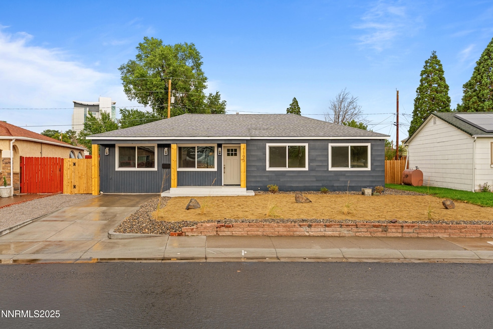


Welcome to 1195 Stewart Street—a beautifully updated 3-bed, 2-bath home that perfectly blends modern upgrades with timeless charm. Tucked into a quiet, established neighborhood just minutes from downtown Reno, this 1,344 sq ft residence offers both convenience and comfort on a generous 0.184-acre lot. Step inside to discover an airy, light-filled layout featuring brand-new LVP flooring, plush new carpet in the bedrooms, and fresh interior/exterior paint. The heart of the home is the open-concept kitchen—perfect for cooking, entertaining, and gathering. You'll love the new cabinetry, sleek granite countertops, stainless steel appliances, and modern sink/faucet combo. Large windows throughout flood the home with natural light, while the brand-new AC system keeps you cool year-round. Retreat to your private backyard, complete with a newly built deck, offering the ideal setting for BBQs, outdoor dining, or simply unwinding after a long day. The oversized lot provides plenty of space for kids, pets, or even a future garden.
This home checks every box—style, comfort, location, and functionality. Whether you're hosting friends, enjoying quiet nights in, or exploring the nearby dining, shopping, and entertainment of downtown Reno, this property is ready to welcome you home.
Last Agent to Sell the Property
TrueNest Properties License #B.1003065 Listed on: 08/29/2025
| Date | Type | Sale Price | Title Company |
|---|---|---|---|
| Bargain Sale Deed | $445,000 | Stewart Title | |
| Bargain Sale Deed | $265,000 | Core Title Group | |
| Public Action Common In Florida Clerks Tax Deed Or Tax Deeds Or Property Sold For Taxes | -- | None Listed On Document | |
| Interfamily Deed Transfer | -- | None Available | |
| Interfamily Deed Transfer | -- | -- |
| Date | Status | Loan Amount | Loan Type |
|---|---|---|---|
| Open | $356,000 | New Conventional |
| Date | Event | Price | List to Sale | Price per Sq Ft |
|---|---|---|---|---|
| 09/24/2025 09/24/25 | Sold | $445,000 | -1.1% | $331 / Sq Ft |
| 08/29/2025 08/29/25 | For Sale | $450,000 | -- | $335 / Sq Ft |
| Year | Tax Paid | Tax Assessment Tax Assessment Total Assessment is a certain percentage of the fair market value that is determined by local assessors to be the total taxable value of land and additions on the property. | Land | Improvement |
|---|---|---|---|---|
| 2026 | $532 | $51,071 | $34,860 | $16,211 |
| 2025 | $1,747 | $50,349 | $34,265 | $16,084 |
| 2024 | $1,747 | $48,920 | $33,040 | $15,880 |
| 2023 | $2,210 | $48,091 | $33,390 | $14,701 |
| 2022 | $618 | $39,482 | $27,825 | $11,657 |
| 2021 | $599 | $29,560 | $18,270 | $11,290 |
| 2020 | $582 | $30,238 | $19,040 | $11,198 |
| 2019 | $566 | $27,228 | $16,660 | $10,568 |
| 2018 | $554 | $22,144 | $12,005 | $10,139 |
| 2017 | $1,162 | $20,528 | $10,430 | $10,098 |
| 2016 | $1,359 | $19,404 | $9,275 | $10,129 |
| 2015 | $1,172 | $17,298 | $7,350 | $9,948 |
| 2014 | $1,672 | $14,628 | $5,250 | $9,378 |
| 2013 | -- | $13,146 | $4,025 | $9,121 |
Seller's Agent in 2025
Wesley Pittman
TrueNest Properties
(775) 544-1169
4 in this area
130 Total Sales
G
Seller Co-Listing Agent in 2025
Grecia Cardona
TrueNest Properties
(775) 722-8672
1 in this area
64 Total Sales
Buyer's Agent in 2025
Sharon Thomson
RE/MAX
(949) 201-8940
2 in this area
64 Total Sales
Source: Northern Nevada Regional MLS
MLS Number: 250055224
APN: 013-032-21
Disclaimer: Certain information contained herein is derived from information provided by parties other than Homes.com. All information provided is deemed reliable, but is not guaranteed to be accurate and should be independently verified.
![]() IDX information is provided exclusively for personal, non-commercial use, and may not be used for any purpose other than to identify prospective properties consumers may be interested in purchasing. Information is deemed reliable but not guaranteed. The content relating to real estate for sale on this web site comes in part from the Broker Reciprocity/ IDX program of the Northern Nevada Regional Multiple Listing Service°. Real estate listings held by brokerage firms other than Ten-X are marked with the Broker Reciprocity logo and detailed information about those listings includes the name of the listing brokerage. Any use of the content other than by a search performed by a consumer looking to purchase or rent real estate is prohibited. © 2025 Northern Nevada Regional Multiple Listing Service® MLS. All rights reserved.
IDX information is provided exclusively for personal, non-commercial use, and may not be used for any purpose other than to identify prospective properties consumers may be interested in purchasing. Information is deemed reliable but not guaranteed. The content relating to real estate for sale on this web site comes in part from the Broker Reciprocity/ IDX program of the Northern Nevada Regional Multiple Listing Service°. Real estate listings held by brokerage firms other than Ten-X are marked with the Broker Reciprocity logo and detailed information about those listings includes the name of the listing brokerage. Any use of the content other than by a search performed by a consumer looking to purchase or rent real estate is prohibited. © 2025 Northern Nevada Regional Multiple Listing Service® MLS. All rights reserved.