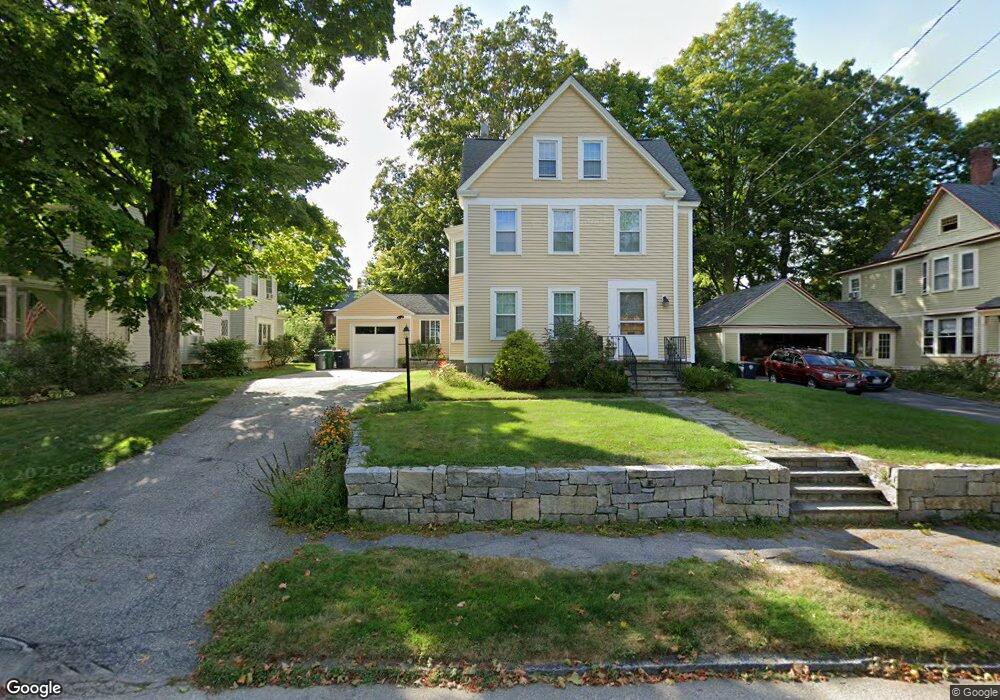
12 Berkeley St Nashua, NH 03064
North End Nashua NeighborhoodEstimated Value: $622,000 - $724,000
3
Beds
4
Baths
2,412
Sq Ft
$274/Sq Ft
Est. Value
About This Home
This home is located at 12 Berkeley St, Nashua, NH 03064 and is currently estimated at $661,188, approximately $274 per square foot. 12 Berkeley St is a home located in Hillsborough County with nearby schools including Mount Pleasant Elementary School, Pennichuck Middle School, and Nashua High School North.
Ownership History
Date
Name
Owned For
Owner Type
Purchase Details
Closed on
Jan 14, 2010
Sold by
Quinn Daniel K and Quinn Fhlmc
Bought by
Warshaw Jacob L and Warshaw Shannon D
Current Estimated Value
Purchase Details
Closed on
Mar 13, 2006
Sold by
Griffith Mabel G Est
Bought by
Quinn Daniel K
Home Financials for this Owner
Home Financials are based on the most recent Mortgage that was taken out on this home.
Original Mortgage
$276,000
Interest Rate
6.15%
Mortgage Type
Purchase Money Mortgage
Create a Home Valuation Report for This Property
The Home Valuation Report is an in-depth analysis detailing your home's value as well as a comparison with similar homes in the area
Home Values in the Area
Average Home Value in this Area
Purchase History
| Date | Buyer | Sale Price | Title Company |
|---|---|---|---|
| Warshaw Jacob L | $249,000 | -- | |
| Quinn Daniel K | $345,000 | -- |
Source: Public Records
Mortgage History
| Date | Status | Borrower | Loan Amount |
|---|---|---|---|
| Open | Quinn Daniel K | $20,000 | |
| Previous Owner | Quinn Daniel K | $276,000 |
Source: Public Records
Tax History
| Year | Tax Paid | Tax Assessment Tax Assessment Total Assessment is a certain percentage of the fair market value that is determined by local assessors to be the total taxable value of land and additions on the property. | Land | Improvement |
|---|---|---|---|---|
| 2024 | $9,416 | $592,200 | $177,600 | $414,600 |
| 2023 | $9,159 | $502,400 | $135,900 | $366,500 |
| 2022 | $9,078 | $502,400 | $135,900 | $366,500 |
| 2021 | $7,616 | $328,000 | $115,400 | $212,600 |
| 2020 | $9,956 | $329,200 | $115,400 | $213,800 |
| 2019 | $7,163 | $329,200 | $115,400 | $213,800 |
| 2018 | $9,290 | $329,200 | $115,400 | $213,800 |
| 2017 | $9,052 | $243,900 | $123,600 | $120,300 |
| 2016 | $6,594 | $243,900 | $123,600 | $120,300 |
| 2015 | $5,983 | $243,900 | $123,600 | $120,300 |
| 2014 | $5,866 | $243,900 | $123,600 | $120,300 |
Source: Public Records
Map
Nearby Homes
- 10 Wood St
- 70 Concord St
- 163 Tolles St
- 7 Morrill St
- 4 Reservoir St
- 86-88 Tolles St
- 46 Perham St Unit 214
- 5 Merrimack St
- 19 Cross St
- 19 Atherton Ave
- 19 Bartlett Ave
- 3 Opal Way Unit 3
- 1 Opal Way Unit 1
- 2 Opal Way Unit 2
- 11 Juliana Ave Unit 52
- 12 Juliana Ave Unit 14
- 10 Juliana Ave
- 16 Juliana Ave
- 54 Campbello St
- 11 Charles St
- 14 Berkeley St
- 10 Berkeley St
- 11 Berkeley St
- 13 Berkeley St
- 15 Berkeley St
- 9 Berkeley St
- 16 Berkeley St
- 51 Concord St
- 8 Berkeley St
- 47 Concord St
- 53 Concord St
- 53 Concord St Unit 1
- 53 Concord St Unit 2
- 7 Berkeley St
- 17 Berkeley St
- 45 Concord St
- 18 Berkeley St
- 14 Chester St
- 55 Concord St
- 55 Concord St Unit 4
Your Personal Tour Guide
Ask me questions while you tour the home.