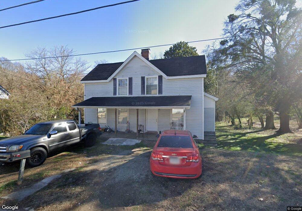
12 Branch St Gainesville, GA 30501
New Holland Village NeighborhoodEstimated Value: $223,000 - $257,894
3
Beds
2
Baths
1,848
Sq Ft
$127/Sq Ft
Est. Value
About This Home
This home is located at 12 Branch St, Gainesville, GA 30501 and is currently estimated at $234,724, approximately $127 per square foot. 12 Branch St is a home located in Hall County with nearby schools including White Sulphur Elementary School, East Hall Middle School, and East Hall High School.
Ownership History
Date
Name
Owned For
Owner Type
Purchase Details
Closed on
Nov 27, 2012
Sold by
Forrester Phillip M
Bought by
Forrester Enterprises Lllp
Current Estimated Value
Purchase Details
Closed on
Jan 16, 2012
Sold by
Cook Betty J
Bought by
Forrester Phillip M
Purchase Details
Closed on
Apr 27, 2007
Sold by
Deaton Michael T and Deaton Jennifer R
Bought by
Cook Betty Jo
Purchase Details
Closed on
May 3, 2004
Sold by
Saine Leone R
Bought by
Gazaway Linda
Create a Home Valuation Report for This Property
The Home Valuation Report is an in-depth analysis detailing your home's value as well as a comparison with similar homes in the area
Home Values in the Area
Average Home Value in this Area
Purchase History
| Date | Buyer | Sale Price | Title Company |
|---|---|---|---|
| Forrester Enterprises Lllp | -- | -- | |
| Forrester Phillip M | $18,000 | -- | |
| Cook Betty Jo | $100,000 | -- | |
| Gazaway Linda | $81,000 | -- | |
| Saine Leone R | -- | -- |
Source: Public Records
Tax History Compared to Growth
Tax History
| Year | Tax Paid | Tax Assessment Tax Assessment Total Assessment is a certain percentage of the fair market value that is determined by local assessors to be the total taxable value of land and additions on the property. | Land | Improvement |
|---|---|---|---|---|
| 2024 | $1,655 | $64,040 | $19,360 | $44,680 |
| 2023 | $1,592 | $61,480 | $17,080 | $44,400 |
| 2022 | $1,427 | $52,560 | $12,320 | $40,240 |
| 2021 | $1,128 | $40,160 | $9,240 | $30,920 |
| 2020 | $902 | $30,640 | $4,920 | $25,720 |
| 2019 | $820 | $27,360 | $4,280 | $23,080 |
| 2018 | $802 | $25,840 | $6,200 | $19,640 |
| 2017 | $706 | $22,640 | $3,120 | $19,520 |
| 2016 | $332 | $9,469 | $3,120 | $6,349 |
| 2015 | $334 | $9,469 | $3,120 | $6,349 |
| 2014 | $334 | $9,469 | $3,120 | $6,349 |
Source: Public Records
Map
Nearby Homes
- 13 Branch St
- 4135 Millstone Park Ln Unit 9A
- 4115 Millstone Park Ln Unit 4A
- 4135 Millstone Park Ln
- 4127 Millstone Park Ln
- 4127 Millstone Park Ln Unit 7A
- 4115 Millstone Park Ln
- 3 Liberty St
- 17 Liberty St
- 15 Liberty St
- 33 Quarry St
- 1 Spring St
- 19 Carolina St
- 00 Jesse Jewell Pkwy
- 1238 Mill St SE
- 17 Spring St
- 20 Spring St
- 37 Spring St
- 0 Autumn Dr Unit 10327035
- 1049 Desota St SE