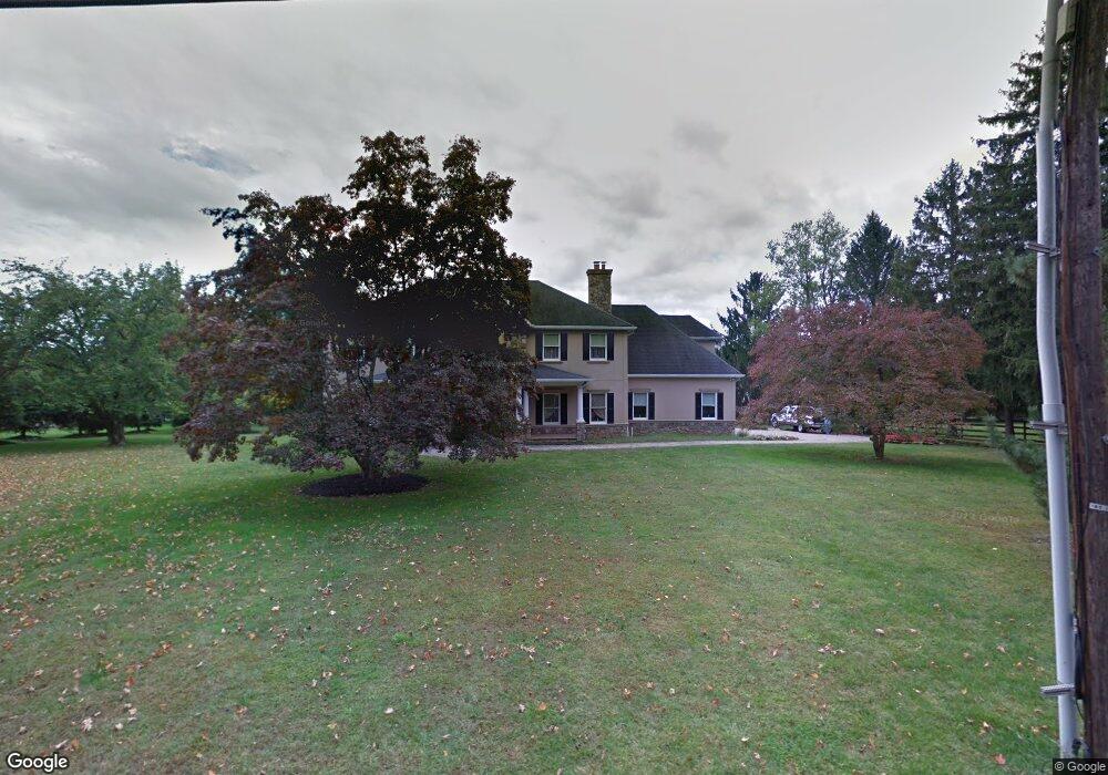
12 Crine Rd Colts Neck, NJ 07722
Estimated Value: $1,127,000 - $1,303,000
3
Beds
3
Baths
3,442
Sq Ft
$350/Sq Ft
Est. Value
About This Home
This home is located at 12 Crine Rd, Colts Neck, NJ 07722 and is currently estimated at $1,203,499, approximately $349 per square foot. 12 Crine Rd is a home located in Monmouth County with nearby schools including Conover Road School, Cedar Drive Middle School, and Colts Neck High School.
Ownership History
Date
Name
Owned For
Owner Type
Purchase Details
Closed on
Feb 6, 2023
Sold by
Wasco Mark and Wasco Nicoletta
Bought by
Mark And Nicoletta Wasco Family Llc
Current Estimated Value
Purchase Details
Closed on
Sep 24, 2003
Sold by
Boese John
Bought by
Wasco Mark and Wasco Nicoletta
Home Financials for this Owner
Home Financials are based on the most recent Mortgage that was taken out on this home.
Original Mortgage
$262,500
Interest Rate
5.9%
Create a Home Valuation Report for This Property
The Home Valuation Report is an in-depth analysis detailing your home's value as well as a comparison with similar homes in the area
Home Values in the Area
Average Home Value in this Area
Purchase History
| Date | Buyer | Sale Price | Title Company |
|---|---|---|---|
| Mark And Nicoletta Wasco Family Llc | -- | First American Title | |
| Wasco Mark | $350,000 | -- |
Source: Public Records
Mortgage History
| Date | Status | Borrower | Loan Amount |
|---|---|---|---|
| Previous Owner | Wasco Mark | $262,500 |
Source: Public Records
Tax History Compared to Growth
Tax History
| Year | Tax Paid | Tax Assessment Tax Assessment Total Assessment is a certain percentage of the fair market value that is determined by local assessors to be the total taxable value of land and additions on the property. | Land | Improvement |
|---|---|---|---|---|
| 2025 | $12,218 | $967,600 | $354,900 | $612,700 |
| 2024 | $12,759 | $820,000 | $282,800 | $537,200 |
| 2023 | $12,759 | $820,000 | $282,800 | $537,200 |
| 2022 | $13,589 | $815,400 | $279,900 | $535,500 |
| 2021 | $13,589 | $778,300 | $233,300 | $545,000 |
| 2020 | $13,306 | $754,300 | $228,800 | $525,500 |
| 2019 | $13,169 | $747,800 | $228,800 | $519,000 |
| 2018 | $13,158 | $741,300 | $228,800 | $512,500 |
| 2017 | $13,190 | $745,600 | $239,600 | $506,000 |
| 2016 | $12,898 | $745,100 | $242,300 | $502,800 |
| 2015 | $12,936 | $745,600 | $255,800 | $489,800 |
| 2014 | $11,409 | $676,300 | $241,600 | $434,700 |
Source: Public Records
Map
Nearby Homes
- 784 State Route 34
- 703 Quail Hill Rd
- 3 Colts Gait Ln
- 17 Woods End Rd
- 145 Heulitt Rd
- 9 Mulberry Ln
- 15 Windsor Place
- 4 Brookside Dr
- 152 Bucks Mill Rd
- 6 Willow Rd
- 20 Birch Ln
- 12 Crest Dr
- 151 Dutch Lane Rd
- 88 Clover Hill Rd
- 10 Livingston Ct
- 1158 State Route 34
- 40 New St
- 39 Mountainside Dr
- 8 Holling Rd
- 21 Holly Hill Rd