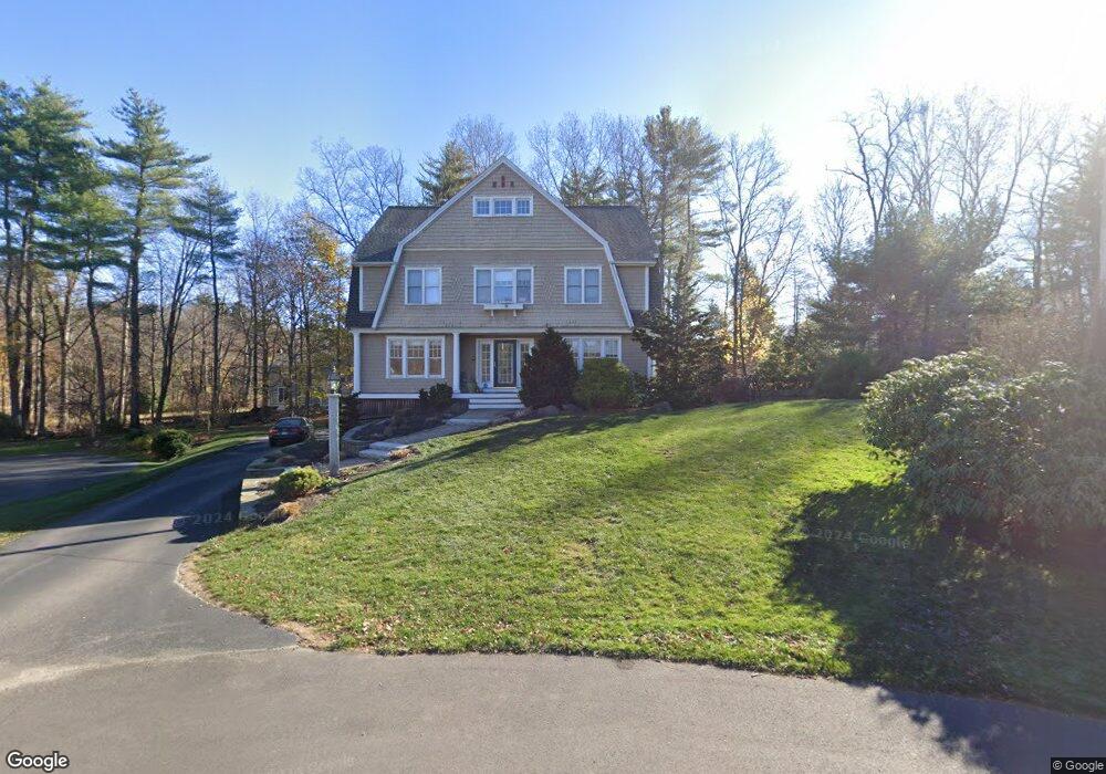
12 Dearborn Brook Cir Exeter, NH 03833
Estimated Value: $1,219,865 - $1,417,000
4
Beds
4
Baths
3,956
Sq Ft
$328/Sq Ft
Est. Value
About This Home
This home is located at 12 Dearborn Brook Cir, Exeter, NH 03833 and is currently estimated at $1,297,966, approximately $328 per square foot. 12 Dearborn Brook Cir is a home located in Rockingham County with nearby schools including Main Street School, Lincoln Street Elementary School, and Cooperative Middle School.
Ownership History
Date
Name
Owned For
Owner Type
Purchase Details
Closed on
Dec 1, 2009
Sold by
Petersen Thomas and Petersen Barbara
Bought by
Kavanaugh Steven and Kavanaugh Lauren E
Current Estimated Value
Home Financials for this Owner
Home Financials are based on the most recent Mortgage that was taken out on this home.
Original Mortgage
$397,300
Interest Rate
4.92%
Mortgage Type
Purchase Money Mortgage
Purchase Details
Closed on
Jun 24, 2003
Sold by
Windemere Dev Llc
Bought by
Petersen Thomas and Petersen Barbara
Create a Home Valuation Report for This Property
The Home Valuation Report is an in-depth analysis detailing your home's value as well as a comparison with similar homes in the area
Home Values in the Area
Average Home Value in this Area
Purchase History
| Date | Buyer | Sale Price | Title Company |
|---|---|---|---|
| Kavanaugh Steven | $572,300 | -- | |
| Petersen Thomas | $561,000 | -- |
Source: Public Records
Mortgage History
| Date | Status | Borrower | Loan Amount |
|---|---|---|---|
| Open | Petersen Thomas | $380,000 | |
| Closed | Petersen Thomas | $395,000 | |
| Closed | Petersen Thomas | $397,300 | |
| Previous Owner | Petersen Thomas | $163,000 |
Source: Public Records
Tax History Compared to Growth
Tax History
| Year | Tax Paid | Tax Assessment Tax Assessment Total Assessment is a certain percentage of the fair market value that is determined by local assessors to be the total taxable value of land and additions on the property. | Land | Improvement |
|---|---|---|---|---|
| 2024 | $17,619 | $990,400 | $268,800 | $721,600 |
| 2023 | $17,624 | $658,100 | $165,300 | $492,800 |
| 2022 | $16,288 | $658,100 | $165,300 | $492,800 |
| 2021 | $15,801 | $658,100 | $165,300 | $492,800 |
| 2020 | $16,117 | $658,100 | $165,300 | $492,800 |
| 2019 | $15,314 | $658,100 | $165,300 | $492,800 |
| 2018 | $17,732 | $644,800 | $142,700 | $502,100 |
| 2017 | $17,264 | $644,900 | $142,700 | $502,200 |
| 2016 | $16,922 | $644,900 | $142,700 | $502,200 |
| 2015 | $16,471 | $644,900 | $142,700 | $502,200 |
| 2014 | $14,737 | $565,500 | $142,700 | $422,800 |
| 2013 | $14,720 | $565,500 | $142,700 | $422,800 |
| 2011 | $14,296 | $565,500 | $142,700 | $422,800 |
Source: Public Records
Map
Nearby Homes
- 0 High St Unit 2
- 61 Acadia Ln Unit 309
- 61 Acadia Ln Unit 310
- 6 Wayside Dr
- 75 High St Unit G4
- 22 Stratham Heights Rd
- 3 Allen St
- 31 Exeter Farms Rd
- 1 Sterling Hill Ln Unit 116
- 5 Sterling Hill Ln Unit 531
- 5 Sterling Hill Ln Unit 514
- 20 River St
- 2 Sterling Hill Ln Unit 211
- 3 Sterling Hill Ln Unit 322
- 3 Sterling Hill Ln Unit 324
- 4 Pine Meadows Dr
- 31 Pinewood Dr
- 10 String Bridge
- 116 Robin Hood Dr
- 101 Robinhood Dr
- 7 Dearborn Brook Cir
- 8 Dearborn Brook Cir
- 6 Langdon Ave
- 14 Langdon Ave
- 12 Langdon Ave
- 10 Langdon Ave
- 5 Dearborn Brook Cir
- 6 Dearborn Brook Cir
- 4 Langdon Ave
- 13 Langdon Ave
- 9 Langdon Ave
- 3 Dearborn Brook Cir
- 4 Dearborn Brook Cir
- 7 Langdon Ave
- 4 Star Ave
- 2 Langdon Ave
- 4 Squamscott Cir
- 25 Windemere
- 8 Appledore Ave
- 10 Appledore Ave