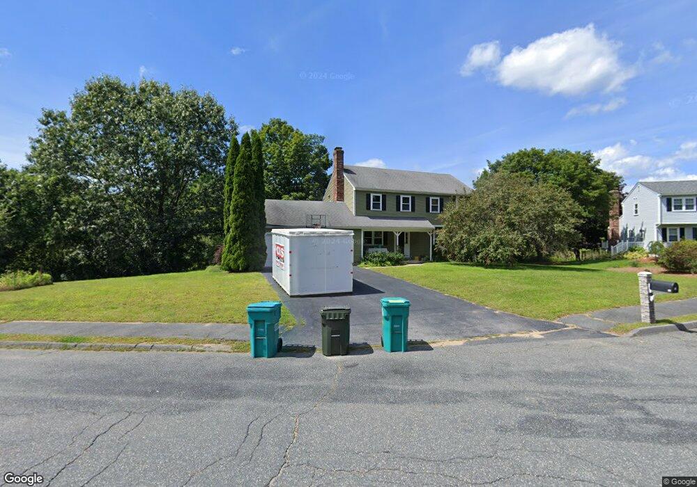
12 Maxwell Cir Hudson, MA 01749
Estimated Value: $707,362 - $814,000
4
Beds
3
Baths
1,900
Sq Ft
$399/Sq Ft
Est. Value
About This Home
This home is located at 12 Maxwell Cir, Hudson, MA 01749 and is currently estimated at $758,591, approximately $399 per square foot. 12 Maxwell Cir is a home located in Middlesex County with nearby schools including David J. Quinn Middle School, Hudson High School, and First Steps Children's Center.
Ownership History
Date
Name
Owned For
Owner Type
Purchase Details
Closed on
Aug 14, 2023
Sold by
Speredelozzi James D and Speredelozzi Jennifer A
Bought by
Speredelozzi James D
Current Estimated Value
Home Financials for this Owner
Home Financials are based on the most recent Mortgage that was taken out on this home.
Original Mortgage
$440,000
Outstanding Balance
$429,918
Interest Rate
6.78%
Mortgage Type
Stand Alone Refi Refinance Of Original Loan
Estimated Equity
$328,673
Purchase Details
Closed on
Nov 21, 2002
Sold by
Halloran Mark R and Hutchinson Wendy W
Bought by
Speredelozzi James D and Speredelozzi Jennifer A
Purchase Details
Closed on
Jun 18, 1999
Sold by
Nadolny John R and Nadolny Mary R
Bought by
Holloran Mark R and Hutchinson Wendy W
Create a Home Valuation Report for This Property
The Home Valuation Report is an in-depth analysis detailing your home's value as well as a comparison with similar homes in the area
Home Values in the Area
Average Home Value in this Area
Purchase History
| Date | Buyer | Sale Price | Title Company |
|---|---|---|---|
| Speredelozzi James D | -- | None Available | |
| Speredelozzi James D | -- | None Available | |
| Speredelozzi James D | -- | None Available | |
| Speredelozzi James D | $355,000 | -- | |
| Speredelozzi James D | $355,000 | -- | |
| Holloran Mark R | $250,000 | -- |
Source: Public Records
Mortgage History
| Date | Status | Borrower | Loan Amount |
|---|---|---|---|
| Open | Speredelozzi James D | $440,000 | |
| Closed | Speredelozzi James D | $440,000 | |
| Previous Owner | Holloran Mark R | $303,200 |
Source: Public Records
Tax History Compared to Growth
Tax History
| Year | Tax Paid | Tax Assessment Tax Assessment Total Assessment is a certain percentage of the fair market value that is determined by local assessors to be the total taxable value of land and additions on the property. | Land | Improvement |
|---|---|---|---|---|
| 2025 | $9,087 | $654,700 | $214,600 | $440,100 |
| 2024 | $8,873 | $633,800 | $195,000 | $438,800 |
| 2023 | $8,093 | $554,300 | $187,600 | $366,700 |
| 2022 | $7,684 | $484,500 | $170,800 | $313,700 |
| 2021 | $11,945 | $441,100 | $162,700 | $278,400 |
| 2020 | $7,312 | $440,200 | $168,000 | $272,200 |
| 2019 | $10,559 | $407,700 | $168,000 | $239,700 |
| 2018 | $7,077 | $404,400 | $170,000 | $234,400 |
| 2017 | $11,456 | $406,500 | $168,400 | $238,100 |
| 2016 | $6,657 | $385,000 | $168,400 | $216,600 |
| 2015 | $6,435 | $372,600 | $167,000 | $205,600 |
| 2014 | $6,125 | $351,600 | $146,200 | $205,400 |
Source: Public Records
Map
Nearby Homes
- 107 Washington St
- 56 Park St
- 17 School St Unit C
- 17 School St Unit A
- 243 Washington St
- 168 River Rd E Unit Lot 15A
- 168 River Rd E Unit Lot 5
- 168 River Rd E Unit Lot 3
- 168 River Rd E Unit Lot 11
- 168 River Rd E Unit Lot 2
- 168 River Rd E Unit Lot 6
- 65 Main St
- 16 Houghton St
- 0 Washington St
- 243 Gates Pond Rd
- 21 Gates Ave
- 18-24 River St Unit 1
- 4 Linden St
- 123 Chapin Rd Unit 1A4
- 11 Barracks Rd Unit 11