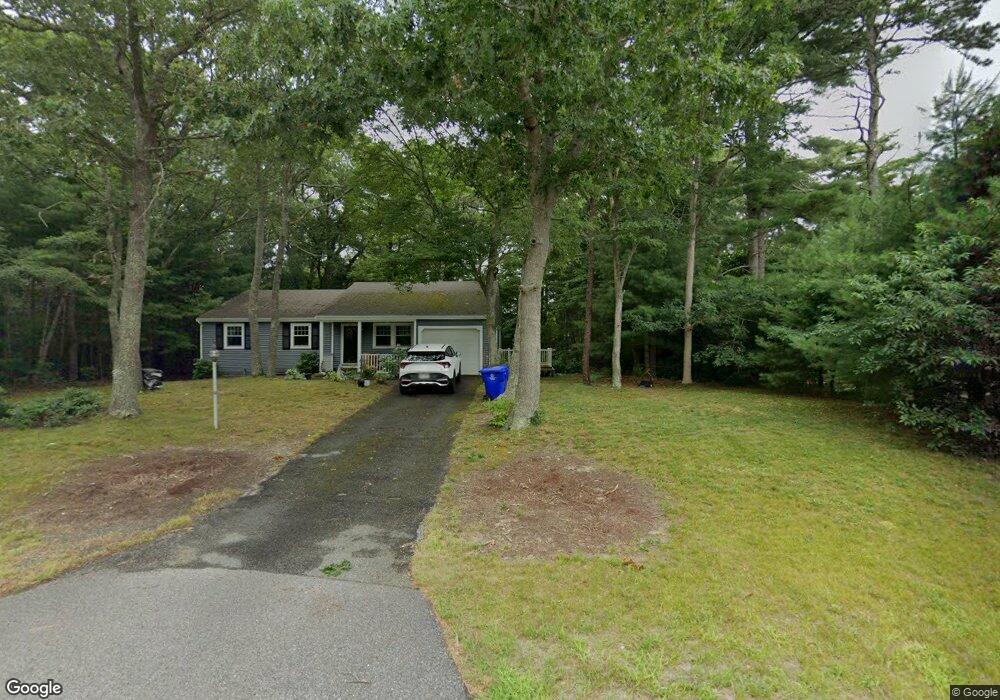
12 Michael Rd Pocasset, MA 02559
Pocasset NeighborhoodEstimated Value: $574,867 - $580,000
2
Beds
2
Baths
1,152
Sq Ft
$500/Sq Ft
Est. Value
About This Home
This home is located at 12 Michael Rd, Pocasset, MA 02559 and is currently estimated at $576,467, approximately $500 per square foot. 12 Michael Rd is a home located in Barnstable County with nearby schools including Bourne High School, Cadence Academy Preschool - Bourne, and St Margaret Regional School.
Ownership History
Date
Name
Owned For
Owner Type
Purchase Details
Closed on
Jul 6, 2022
Sold by
Ford Donald J and Ford Rosemarie
Bought by
Ford Donald J and Ford Rosemarie
Current Estimated Value
Create a Home Valuation Report for This Property
The Home Valuation Report is an in-depth analysis detailing your home's value as well as a comparison with similar homes in the area
Home Values in the Area
Average Home Value in this Area
Purchase History
| Date | Buyer | Sale Price | Title Company |
|---|---|---|---|
| Ford Donald J | -- | None Available | |
| Ford Donald J | -- | None Available |
Source: Public Records
Tax History
| Year | Tax Paid | Tax Assessment Tax Assessment Total Assessment is a certain percentage of the fair market value that is determined by local assessors to be the total taxable value of land and additions on the property. | Land | Improvement |
|---|---|---|---|---|
| 2025 | $3,870 | $495,500 | $223,500 | $272,000 |
| 2024 | $3,692 | $460,300 | $212,800 | $247,500 |
| 2023 | $3,518 | $399,300 | $180,200 | $219,100 |
| 2022 | $3,729 | $369,600 | $195,700 | $173,900 |
| 2021 | $3,623 | $336,400 | $178,100 | $158,300 |
| 2020 | $3,512 | $327,000 | $176,400 | $150,600 |
| 2019 | $3,348 | $318,600 | $176,400 | $142,200 |
| 2018 | $3,126 | $296,600 | $168,000 | $128,600 |
| 2017 | $2,915 | $283,000 | $154,100 | $128,900 |
| 2016 | $2,814 | $277,000 | $154,100 | $122,900 |
| 2015 | $2,789 | $277,000 | $154,100 | $122,900 |
Source: Public Records
Map
Nearby Homes
- 16 Michael Rd
- 254 Barlows Landing Rd
- 709 County Rd
- 3 4th Ave
- 7 4th Ave
- 3 1st St
- 14 Navajo Rd
- 48 Red Brook Harbor Rd
- 566 Shore Rd
- 1234 Route 28a
- 1234 Route 28a
- 20 Colony Ave
- 15 Oak Ave
- 75 Winsor Rd
- 4 Harbor Hill Dr
- 16 Amberwood Ct
- 31 Baxendale Rd
- 203 County Rd
- 12 Turnberry Rd Unit 12
- 4 Hollyhock Knoll Ct Unit 4
- 10 Michael Rd
- 14 Michael Rd
- 241 Barlows Landing Rd
- 8 Michael Rd
- 1 Keith Rd
- 245 Barlows Landing Rd
- 22 Oakdale Valley Rd
- 247 Barlows Landing Rd
- 7 Michael Rd
- 6 Michael Rd
- 4 Keith Rd
- 15 Michael Rd
- 18 Michael Rd
- 22 Keith Rd
- 5 Keith Rd
- 229 Barlows Landing Rd
- 5 Michael Rd
- 4 Michael Rd
- 6 Keith Rd
- 8 Oak Ridge
Your Personal Tour Guide
Ask me questions while you tour the home.