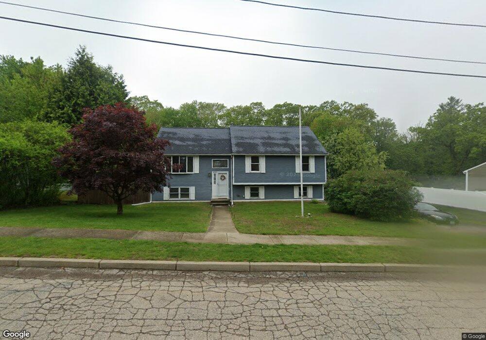
12 Sheri Dr Coventry, RI 02816
Estimated Value: $488,539 - $641,000
3
Beds
3
Baths
1,900
Sq Ft
$286/Sq Ft
Est. Value
About This Home
This home is located at 12 Sheri Dr, Coventry, RI 02816 and is currently estimated at $543,885, approximately $286 per square foot. 12 Sheri Dr is a home located in Kent County with nearby schools including Alan Shawn Feinstein Ms Of Cov, Coventry High School, and Father John V. Doyle School.
Ownership History
Date
Name
Owned For
Owner Type
Purchase Details
Closed on
Apr 18, 2025
Sold by
Steven M Obrien T M and Steven Obrien
Bought by
Carla K Obrien T K and Carla Obrien
Current Estimated Value
Purchase Details
Closed on
Oct 29, 2020
Sold by
Obrien Steven M and Obrien Lisa C
Bought by
Steven Steven M and Steven L T
Purchase Details
Closed on
Sep 29, 1997
Sold by
Collymore Fitz G and Collymore Gladys
Bought by
Obrien Steven M and Obrien Lisa
Create a Home Valuation Report for This Property
The Home Valuation Report is an in-depth analysis detailing your home's value as well as a comparison with similar homes in the area
Purchase History
| Date | Buyer | Sale Price | Title Company |
|---|---|---|---|
| Carla K Obrien T K | -- | None Available | |
| Carla K Obrien T K | -- | None Available | |
| Steven Steven M | -- | None Available | |
| Steven M M | -- | None Available | |
| Obrien Steven M | $145,000 | -- | |
| Obrien Steven M | $145,000 | -- |
Source: Public Records
Mortgage History
| Date | Status | Borrower | Loan Amount |
|---|---|---|---|
| Previous Owner | Obrien Steven M | $124,500 | |
| Previous Owner | Obrien Steven M | $50,000 | |
| Previous Owner | Obrien Steven M | $130,000 |
Source: Public Records
Tax History
| Year | Tax Paid | Tax Assessment Tax Assessment Total Assessment is a certain percentage of the fair market value that is determined by local assessors to be the total taxable value of land and additions on the property. | Land | Improvement |
|---|---|---|---|---|
| 2025 | $5,903 | $366,900 | $111,900 | $255,000 |
| 2024 | $5,908 | $373,000 | $111,900 | $261,100 |
| 2023 | $5,718 | $373,000 | $111,900 | $261,100 |
| 2022 | $6,204 | $317,000 | $106,700 | $210,300 |
| 2021 | $5,766 | $297,200 | $106,700 | $190,500 |
| 2020 | $6,610 | $297,200 | $106,700 | $190,500 |
| 2019 | $5,182 | $233,000 | $70,500 | $162,500 |
| 2018 | $5,035 | $233,000 | $70,500 | $162,500 |
| 2017 | $4,888 | $233,000 | $70,500 | $162,500 |
| 2016 | $5,192 | $242,500 | $110,100 | $132,400 |
| 2015 | $5,051 | $242,500 | $110,100 | $132,400 |
| 2014 | $4,946 | $242,500 | $110,100 | $132,400 |
| 2013 | $4,742 | $254,100 | $110,100 | $144,000 |
Source: Public Records
Map
Nearby Homes
Your Personal Tour Guide
Ask me questions while you tour the home.