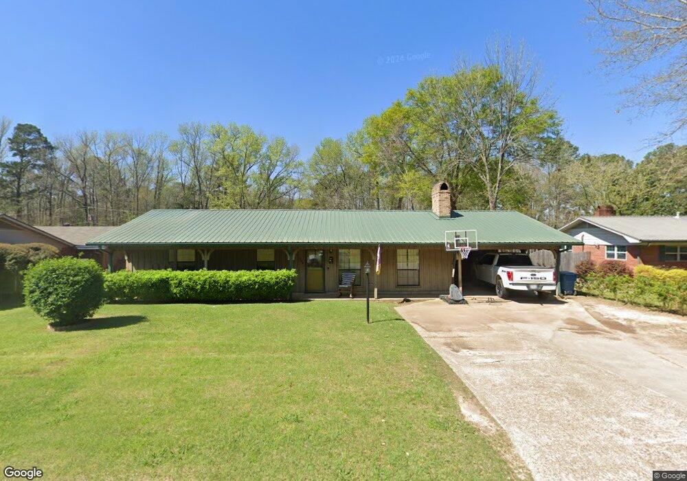
120 General Beauregard Dr Vivian, LA 71082
Estimated Value: $107,196 - $154,000
3
Beds
2
Baths
1,493
Sq Ft
$91/Sq Ft
Est. Value
About This Home
This home is located at 120 General Beauregard Dr, Vivian, LA 71082 and is currently estimated at $136,549, approximately $91 per square foot. 120 General Beauregard Dr is a home located in Caddo Parish with nearby schools including South Highlands Elementary, Judson Fundamental Elementary School, and Fairfield Magnet School.
Ownership History
Date
Name
Owned For
Owner Type
Purchase Details
Closed on
Jun 30, 2015
Sold by
Davis Seth Allen and Davis Haylee Dawn Hale
Bought by
Brand Jeremy Garrett and Brand Katie Lynn Blackwell
Current Estimated Value
Purchase Details
Closed on
Nov 23, 2005
Sold by
Alexander David Eric and Alexander Susan Camille Sharp
Bought by
Davis Seth Alan
Home Financials for this Owner
Home Financials are based on the most recent Mortgage that was taken out on this home.
Original Mortgage
$76,000
Interest Rate
6.12%
Mortgage Type
New Conventional
Create a Home Valuation Report for This Property
The Home Valuation Report is an in-depth analysis detailing your home's value as well as a comparison with similar homes in the area
Home Values in the Area
Average Home Value in this Area
Purchase History
| Date | Buyer | Sale Price | Title Company |
|---|---|---|---|
| Brand Jeremy Garrett | $118,000 | None Available | |
| Davis Seth Alan | $95,000 | None Available |
Source: Public Records
Mortgage History
| Date | Status | Borrower | Loan Amount |
|---|---|---|---|
| Previous Owner | Davis Seth Alan | $76,000 | |
| Previous Owner | Davis Seth Alan | $12,750 |
Source: Public Records
Tax History Compared to Growth
Tax History
| Year | Tax Paid | Tax Assessment Tax Assessment Total Assessment is a certain percentage of the fair market value that is determined by local assessors to be the total taxable value of land and additions on the property. | Land | Improvement |
|---|---|---|---|---|
| 2024 | $1,414 | $7,851 | $630 | $7,221 |
| 2023 | $1,317 | $7,139 | $600 | $6,539 |
| 2022 | $1,317 | $7,139 | $600 | $6,539 |
| 2021 | $1,318 | $7,139 | $600 | $6,539 |
| 2020 | $1,310 | $7,139 | $600 | $6,539 |
| 2019 | $1,288 | $7,087 | $600 | $6,487 |
| 2018 | $75 | $7,087 | $600 | $6,487 |
| 2017 | $1,285 | $7,087 | $600 | $6,487 |
| 2015 | $77 | $7,514 | $600 | $6,914 |
| 2014 | $75 | $7,090 | $600 | $6,490 |
| 2013 | -- | $7,090 | $600 | $6,490 |
Source: Public Records
Map
Nearby Homes
- 62011 Rebel Heights Rd
- 325 E Oklahoma Ave
- 9420 Hosston Rd
- 122 S Bird St
- 109 N Huckaby St
- 310 W Tennessee Ave
- 9794 Upper State Line Rd
- 210 W Mississippi Ave
- Lot 14 Peaceful Pines Ln
- Lot 4 Peaceful Pines Ln
- Lot 2 Peaceful Pines Ln
- Lot 6 Peaceful Pines Ln
- Lot 5 Peaceful Pines Ln
- Lot 12 Peaceful Pines Ln
- 0 Camelia St
- 9008 Hosston Vivian Rd
- 1220 N Carson St
- 2040 Ma County Road 3509
- 2040 McR 3509
- 10651 Murry Ln
- 118 General Beauregard Dr
- 118 General Beauregard Dr
- 116 General Beauregard Dr
- 117 General Beauregard Dr
- 117 General Beauregard Dr
- 114 General Beauregard Dr
- 126 General Beauregard Dr
- 120 General Lee Dr
- 118 General Lee Dr
- 122 General Lee Dr
- 116 General Lee Dr
- 129 General Beauregard Dr
- 124 General Lee Dr
- 111 General Beauregard Dr
- 114 General Lee Dr
- 126 General Lee Dr
- 130 General Beauregard Dr
- 112 General Lee Dr
- 128 General Lee Dr
- 117 General Lee Dr