
Seller's Agent in 2025
Matt Jones
Coldwell Banker Sea Coast Advantage-Hampstead
(336) 504-4078
70 in this area
373 Total Sales
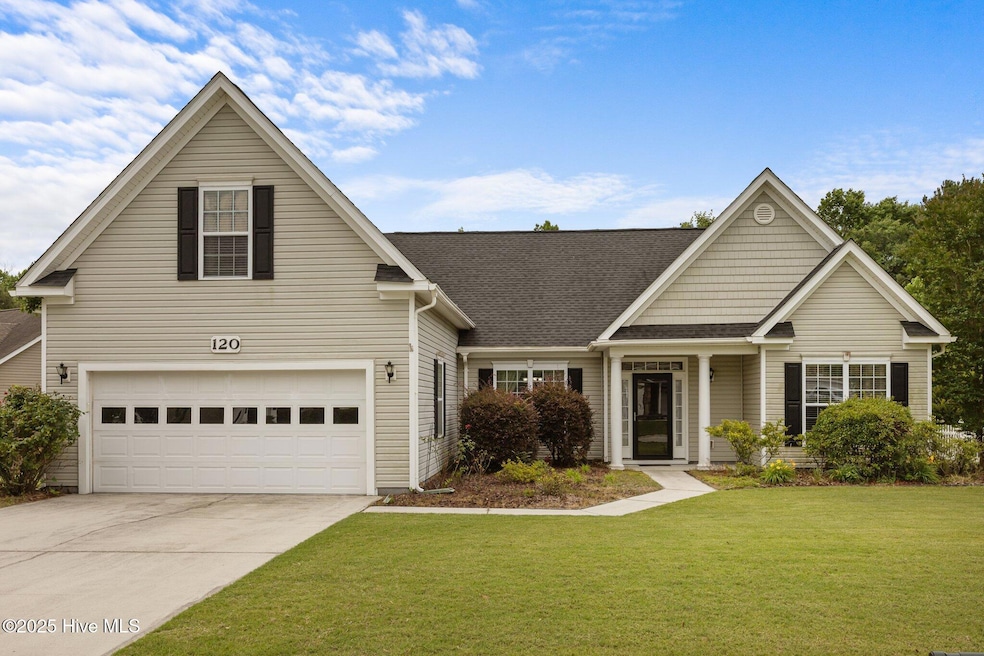


Welcome to this beautiful 3-bedroom, 2-bathroom home with a spacious bonus room, located in the desirable community of The Villages of Turtle Creek. Just minutes from the stunning beaches of Topsail Island and Surf City, this home offers the perfect balance of coastal living and everyday convenience.Step inside to a bright and welcoming entryway that opens to a formal dining room and expansive open-concept living area. Vaulted ceilings and a cozy fireplace create a warm and inviting space ideal for relaxing or entertaining. The kitchen features granite countertops, ample cabinet space with pull-out drawers, a pantry, garbage disposal, and an adjacent laundry room for added functionality.The thoughtfully designed split floor plan provides privacy, with two guest bedrooms and a full guest bath on one side and the owner's suite on the other. The spacious master bedroom boasts vaulted ceilings, his-and-hers walk-in closets, and French doors leading to a versatile flex room--perfect for a home office, nursery, or reading nook. The ensuite bathroom offers dual vanities, a separate soaker tub, and a standalone shower.Upstairs, a generous bonus room above the garage awaits your personal touch--ideal as a guest room, playroom, or additional living space.Enjoy peaceful outdoor living with a screened-in porch, a custom paver grilling pad, and a fully fenced backyard shaded by mature trees.Community amenities include sidewalks, a sparkling pool, clubhouse, and playground--perfect for enjoying the neighborhood's quiet charm while being just minutes from Surf City's shops, restaurants, and vibrant coastal lifestyle.Don't miss the opportunity to make this beautiful home yours
Last Agent to Sell the Property
Coldwell Banker Sea Coast Advantage-Hampstead License #C29259 Listed on: 05/30/2025
| Date | Type | Sale Price | Title Company |
|---|---|---|---|
| Warranty Deed | $430,000 | None Listed On Document | |
| Warranty Deed | $430,000 | None Listed On Document | |
| Warranty Deed | $266,500 | -- |
| Date | Status | Loan Amount | Loan Type |
|---|---|---|---|
| Open | $344,000 | New Conventional | |
| Closed | $344,000 | New Conventional | |
| Previous Owner | $262,971 | VA | |
| Previous Owner | $265,961 | VA | |
| Previous Owner | $264,448 | VA | |
| Previous Owner | $217,150 | VA | |
| Previous Owner | $213,211 | VA | |
| Previous Owner | $0 | Assumption | |
| Previous Owner | $175,442 | VA | |
| Previous Owner | $147,805 | New Conventional | |
| Previous Owner | $151,700 | New Conventional |
| Date | Event | Price | Change | Sq Ft Price |
|---|---|---|---|---|
| 08/13/2025 08/13/25 | Sold | $430,000 | +2.4% | $193 / Sq Ft |
| 06/08/2025 06/08/25 | Pending | -- | -- | -- |
| 05/30/2025 05/30/25 | For Sale | $420,000 | -- | $188 / Sq Ft |
| Year | Tax Paid | Tax Assessment Tax Assessment Total Assessment is a certain percentage of the fair market value that is determined by local assessors to be the total taxable value of land and additions on the property. | Land | Improvement |
|---|---|---|---|---|
| 2024 | $2,006 | $241,680 | $70,048 | $171,632 |
| 2023 | $1,782 | $241,680 | $70,048 | $171,632 |
| 2022 | $1,782 | $241,680 | $70,048 | $171,632 |
| 2021 | $1,782 | $241,680 | $70,048 | $171,632 |
| 2020 | $1,782 | $241,680 | $70,048 | $171,632 |
| 2019 | $1,782 | $241,680 | $70,048 | $171,632 |
| 2018 | $1,755 | $225,665 | $68,000 | $157,665 |
| 2017 | $1,755 | $225,665 | $68,000 | $157,665 |
| 2016 | $1,732 | $225,665 | $68,000 | $157,665 |
| 2015 | $1,732 | $225,665 | $68,000 | $157,665 |
| 2014 | $1,319 | $225,665 | $68,000 | $157,665 |
| 2013 | -- | $225,665 | $68,000 | $157,665 |
| 2012 | -- | $225,665 | $68,000 | $157,665 |
Seller's Agent in 2025
Matt Jones
Coldwell Banker Sea Coast Advantage-Hampstead
(336) 504-4078
70 in this area
373 Total Sales
S
Seller Co-Listing Agent in 2025
Stephanie Modlin
Coldwell Banker Sea Coast Advantage-Hampstead
(910) 270-8880
11 in this area
114 Total Sales
Buyer's Agent in 2025
Rhomni Williams
Fathom Realty NC LLC
(919) 306-2638
1 in this area
44 Total Sales
Source: Hive MLS
MLS Number: 100510698
APN: 4225-88-8945-0000
Disclaimer: Certain information contained herein is derived from information provided by parties other than Homes.com. All information provided is deemed reliable, but is not guaranteed to be accurate and should be independently verified.
![]() The data relating to real estate on this web site comes in part from the Internet Data Exchange program of Hive MLS LLC. All information is deemed reliable but not guaranteed and should be independently verified. All properties are subject to prior sale, change, or withdrawal. Neither listing broker(s) nor Homesnap, Inc. shall be responsible for any typographical errors, misinformation, or misprints, and shall be held totally harmless from any damages arising from reliance upon these data. ©2025 Hive MLS LLC
The data relating to real estate on this web site comes in part from the Internet Data Exchange program of Hive MLS LLC. All information is deemed reliable but not guaranteed and should be independently verified. All properties are subject to prior sale, change, or withdrawal. Neither listing broker(s) nor Homesnap, Inc. shall be responsible for any typographical errors, misinformation, or misprints, and shall be held totally harmless from any damages arising from reliance upon these data. ©2025 Hive MLS LLC