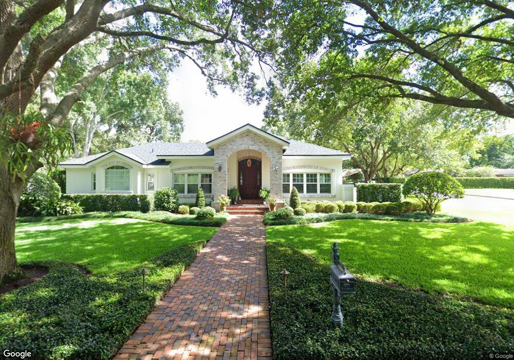
1201 Tom Gurney Dr Winter Park, FL 32789
Estimated Value: $1,692,000 - $2,500,000
4
Beds
3
Baths
3,318
Sq Ft
$641/Sq Ft
Est. Value
About This Home
This home is located at 1201 Tom Gurney Dr, Winter Park, FL 32789 and is currently estimated at $2,128,008, approximately $641 per square foot. 1201 Tom Gurney Dr is a home located in Orange County with nearby schools including Dommerich Elementary School, Maitland Middle School, and Winter Park High.
Ownership History
Date
Name
Owned For
Owner Type
Purchase Details
Closed on
May 24, 1999
Sold by
Tall Reginald and Tall Alice R
Bought by
Simms Stephen A and Simms Ava W
Current Estimated Value
Home Financials for this Owner
Home Financials are based on the most recent Mortgage that was taken out on this home.
Original Mortgage
$440,000
Outstanding Balance
$112,088
Interest Rate
6.87%
Mortgage Type
New Conventional
Estimated Equity
$2,015,920
Purchase Details
Closed on
Aug 19, 1993
Sold by
Ailes David S and Ailes Jeanne B
Bought by
Tall Reginald and Tall Alice R
Home Financials for this Owner
Home Financials are based on the most recent Mortgage that was taken out on this home.
Original Mortgage
$296,000
Interest Rate
7.24%
Create a Home Valuation Report for This Property
The Home Valuation Report is an in-depth analysis detailing your home's value as well as a comparison with similar homes in the area
Home Values in the Area
Average Home Value in this Area
Purchase History
| Date | Buyer | Sale Price | Title Company |
|---|---|---|---|
| Simms Stephen A | $550,000 | -- | |
| Tall Reginald | $225,500 | -- | |
| Ailes David S | -- | -- |
Source: Public Records
Mortgage History
| Date | Status | Borrower | Loan Amount |
|---|---|---|---|
| Open | Simms Stephen A | $440,000 | |
| Previous Owner | Ailes David S | $296,000 |
Source: Public Records
Tax History Compared to Growth
Tax History
| Year | Tax Paid | Tax Assessment Tax Assessment Total Assessment is a certain percentage of the fair market value that is determined by local assessors to be the total taxable value of land and additions on the property. | Land | Improvement |
|---|---|---|---|---|
| 2025 | $11,450 | $772,225 | -- | -- |
| 2024 | $11,022 | $772,225 | -- | -- |
| 2023 | $11,022 | $728,604 | $0 | $0 |
| 2022 | $10,319 | $707,383 | $0 | $0 |
| 2021 | $10,212 | $686,780 | $0 | $0 |
| 2020 | $9,825 | $677,298 | $0 | $0 |
| 2019 | $10,164 | $662,070 | $0 | $0 |
| 2018 | $10,112 | $649,725 | $0 | $0 |
| 2017 | $10,027 | $948,346 | $629,050 | $319,296 |
| 2016 | $9,825 | $940,585 | $629,050 | $311,535 |
| 2015 | $10,061 | $856,762 | $547,000 | $309,762 |
| 2014 | $10,148 | $689,721 | $420,000 | $269,721 |
Source: Public Records
Map
Nearby Homes
- 2190 Temple Dr
- 1860 Via Contessa
- 1229 Via Del Mar
- 2407 Lafayette Ave
- 1742 Temple Dr
- 1760 Via Venetia
- 1612 Magnolia Ave
- 1540 Palm Ave
- 2211 Azalea Place
- 1521 Chestnut Ave
- 2304 Depauw Ave
- 1450 Chestnut Ave
- 952 Moss Ln
- 2607 Lafayette Ave
- 2612 Lafayette Ave
- 2661 Vía Tuscany
- 1611 Tioga Trail
- 913 Moss Ln
- 1710 Oneco Ave
- 184 Sandlewood Trail Unit 2
- 1177 Tom Gurney Dr
- 2070 Sharon Rd
- 2051 Sharon Rd
- 2080 Sharon Rd
- 2060 Sharon Rd
- 1200 Tom Gurney Dr
- 1157 Tom Gurney Dr
- 1180 Tom Gurney Dr
- 2090 Sharon Rd
- 2050 Sharon Rd
- 1208 Sharon Place
- 2071 Temple Dr
- 1160 Tom Gurney Dr
- 1200 Sharon Place
- 2081 Temple Dr
- 2061 Temple Dr
- 1220 Sharon Place
- 2036 Sharon Rd
- 2051 Temple Dr
- 2091 Temple Dr