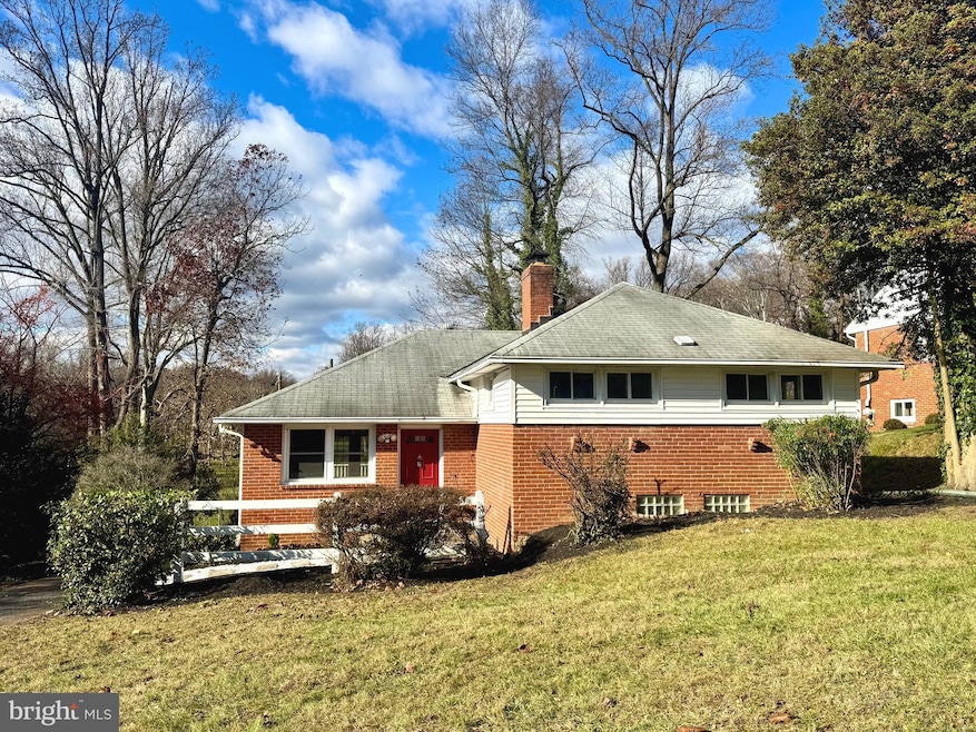
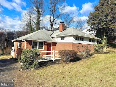


1204 Saint Andrews Way Baltimore, MD 21239
Estimated payment $3,287/month
Highlights
- Golf Course View
- Deck
- Wood Flooring
- Towson High Law & Public Policy Rated A
- Traditional Floor Plan
- No HOA
About This Home
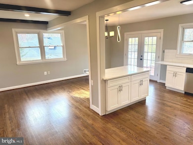
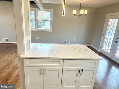
WOW! This One Is Nice!! (BIGGER THAN IT LOOKS!) Lots of Levels (4) and Plenty of Private Space! One of the Largest! (Possible 4th/5th Bedroom and Possible Office/Sitting Area with Built-Ins on Landing). Almost 2400 Sq.Ft. of Finished Space! Come See this Wonderful Home in a GREAT Location! This ONE Backs to the Golf Course! (Great Views But Far Enough Away) You'll Love the New Kitchen and Baths that Add to the Amenities!! Complete with Kitchen Island and ALL NEW Appliances. Fireplace in Living Room Adds to the Ambiance and Comfort! Build Memories. Wood Floors and So MUCH More! Relax and Enjoy! See This One TODAY!
Home Details
Home Type
- Single Family
Est. Annual Taxes
- $4,703
Year Built
- Built in 1955
Lot Details
- 9,555 Sq Ft Lot
- Open Lot
- Property is in very good condition
Parking
- Driveway
Property Views
- Golf Course
- Woods
Home Design
- Split Level Home
- Brick Exterior Construction
- Block Foundation
- Asphalt Roof
Interior Spaces
- Property has 4 Levels
- Traditional Floor Plan
- Built-In Features
- Fireplace With Glass Doors
- Family Room
- Living Room
- Dining Room
- Wood Flooring
Kitchen
- Electric Oven or Range
- Microwave
- Dishwasher
Bedrooms and Bathrooms
- 3 Bedrooms
Laundry
- Dryer
- Washer
Improved Basement
- Basement Fills Entire Space Under The House
- Connecting Stairway
- Laundry in Basement
Outdoor Features
- Deck
- Screened Patio
- Porch
Utilities
- Forced Air Heating and Cooling System
- Electric Water Heater
Community Details
- No Home Owners Association
- Glendale Subdivision
Listing and Financial Details
- Coming Soon on 12/3/25
- Tax Lot 3
- Assessor Parcel Number 04090913753640
Map
Home Values in the Area
Average Home Value in this Area
Tax History
| Year | Tax Paid | Tax Assessment Tax Assessment Total Assessment is a certain percentage of the fair market value that is determined by local assessors to be the total taxable value of land and additions on the property. | Land | Improvement |
|---|---|---|---|---|
| 2025 | $4,597 | $302,800 | $95,600 | $207,200 |
| 2024 | $4,597 | $285,533 | $0 | $0 |
| 2023 | $2,053 | $268,267 | $0 | $0 |
| 2022 | $3,846 | $251,000 | $86,400 | $164,600 |
| 2021 | $3,807 | $244,900 | $0 | $0 |
| 2020 | $3,807 | $238,800 | $0 | $0 |
| 2019 | $3,728 | $232,700 | $86,400 | $146,300 |
| 2018 | $3,715 | $231,067 | $0 | $0 |
| 2017 | $3,630 | $229,433 | $0 | $0 |
| 2016 | $3,295 | $227,800 | $0 | $0 |
| 2015 | $3,295 | $227,800 | $0 | $0 |
| 2014 | $3,295 | $227,800 | $0 | $0 |
Purchase History
| Date | Type | Sale Price | Title Company |
|---|---|---|---|
| Trustee Deed | $311,000 | None Listed On Document | |
| Interfamily Deed Transfer | -- | None Available | |
| Deed | $238,000 | -- | |
| Deed | -- | -- | |
| Deed | $27,000 | -- |
Mortgage History
| Date | Status | Loan Amount | Loan Type |
|---|---|---|---|
| Open | $310,100 | Construction |
Source: Bright MLS
MLS Number: MDBC2147220
APN: 09-0913753640
Disclaimer: Certain information contained herein is derived from information provided by parties other than Homes.com. All information provided is deemed reliable, but is not guaranteed to be accurate and should be independently verified.
![]() The data relating to real estate for sale on this website appears in part through the BRIGHT Internet Data Exchange program, a voluntary cooperative exchange of property listing data between licensed real estate brokerage firms, and is provided by BRIGHT through a licensing agreement.
The data relating to real estate for sale on this website appears in part through the BRIGHT Internet Data Exchange program, a voluntary cooperative exchange of property listing data between licensed real estate brokerage firms, and is provided by BRIGHT through a licensing agreement.
Listing information is from various brokers who participate in the Bright MLS IDX program and not all listings may be visible on the site.
The property information being provided on or through the website is for the personal, non-commercial use of consumers and such information may not be used for any purpose other than to identify prospective properties consumers may be interested in purchasing.
Some properties which appear for sale on the website may no longer be available because they are for instance, under contract, sold or are no longer being offered for sale.
Property information displayed is deemed reliable but is not guaranteed.
Copyright 2025 Bright MLS, Inc.
- 6923 Summit Cir
- 6931 Summit Cir
- 1108 Litchfield Rd
- 6702 Queens Ferry Rd
- 1120 Litchfield Rd
- 12 Stone Ridge Ct
- 28 Stone Ridge Ct
- 908 Stevenson Ln
- 6416 Sherwood Rd
- 6415 Falkirk Rd
- 664 Regester Ave
- 724 Overbrook Rd
- 6216 Falkirk Rd
- 625 Yarmouth Rd
- 1117 Walker Ave
- 1377 Walker Ave
- 1283 Gittings Ave
- 6204 Falkirk Rd
- 701 Hillen Rd
- 703 Hillen Rd
- 6906 Donachie Rd
- 6535 Falkirk Rd
- 1327 Limit Ave
- 6612 Wycombe Way
- 1408 Cedarcroft Rd
- 34 Dowling Cir
- 1330 Meridene Dr
- 6101 Loch Raven Blvd
- 5 Fellowship Ct
- 7113 Bristol Rd
- 6138 Macbeth Dr Unit 1st Floor
- 8119 Kirkwall Ct
- 8106 Pleasant Plains Rd
- 7914 Knollwood Rd
- 633 Walker Ave
- 1104 Meridene Dr Unit 1
- 1109 Meridene Dr
- 6161 Parkway Dr Unit 2
- 6103 Chinquapin Pkwy
- 1302 Hillsway Ct
