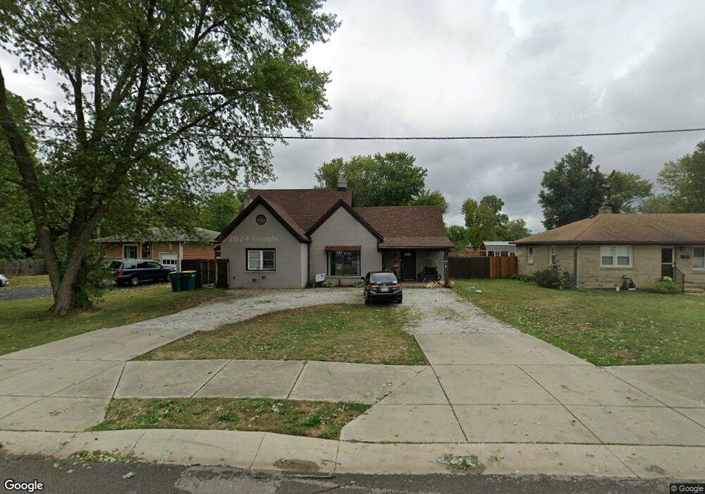
1207 E Buchanan St Plainfield, IN 46168
Estimated Value: $233,446 - $292,000
2
Beds
1
Bath
1,352
Sq Ft
$192/Sq Ft
Est. Value
About This Home
This home is located at 1207 E Buchanan St, Plainfield, IN 46168 and is currently estimated at $259,612, approximately $192 per square foot. 1207 E Buchanan St is a home located in Hendricks County with nearby schools including Brentwood Elementary School, Plainfield Community Middle School, and Plainfield High School.
Ownership History
Date
Name
Owned For
Owner Type
Purchase Details
Closed on
Aug 12, 2020
Sold by
Epperson Anthony and Epperson Millie L
Bought by
Epperson Rentals Llc
Current Estimated Value
Purchase Details
Closed on
Dec 14, 2006
Sold by
Deutsche Bank National Trust Company
Bought by
Epperson Anthony and Epperson Millie L
Purchase Details
Closed on
Apr 20, 2006
Sold by
Black Larry and Black Mary
Bought by
Deutsche Bank National Trust Co
Create a Home Valuation Report for This Property
The Home Valuation Report is an in-depth analysis detailing your home's value as well as a comparison with similar homes in the area
Home Values in the Area
Average Home Value in this Area
Purchase History
| Date | Buyer | Sale Price | Title Company |
|---|---|---|---|
| Epperson Rentals Llc | -- | None Available | |
| Epperson Anthony | -- | None Available | |
| Deutsche Bank National Trust Co | -- | None Available |
Source: Public Records
Tax History
| Year | Tax Paid | Tax Assessment Tax Assessment Total Assessment is a certain percentage of the fair market value that is determined by local assessors to be the total taxable value of land and additions on the property. | Land | Improvement |
|---|---|---|---|---|
| 2025 | $2,351 | $127,900 | $40,000 | $87,900 |
| 2024 | $2,351 | $121,200 | $13,300 | $107,900 |
| 2023 | $2,298 | $115,300 | $12,600 | $102,700 |
| 2022 | $2,196 | $109,800 | $12,000 | $97,800 |
| 2021 | $1,940 | $97,000 | $12,000 | $85,000 |
| 2020 | $2,151 | $107,500 | $12,000 | $95,500 |
| 2019 | $2,028 | $101,400 | $11,300 | $90,100 |
| 2018 | $1,649 | $82,400 | $9,400 | $73,000 |
| 2017 | $1,617 | $80,800 | $10,800 | $70,000 |
| 2016 | $1,563 | $78,100 | $10,800 | $67,300 |
| 2014 | $1,492 | $74,500 | $10,400 | $64,100 |
Source: Public Records
Map
Nearby Homes
- 407 Dunn St
- 324 Holiday Dr
- 2668 Marjorie Ln
- 228 Shaw St
- 1713 Sycamore Dr
- 800 Walton Dr
- 980 Andico Rd
- 1710 Beechwood Dr
- 303 Green St
- 329 Avon Ave
- 2394 Eagle Ave
- 2198 Galleone Way
- 7683 Fairwood Blvd
- 1429 Blackthorne Trail N
- 504 Magnolia Dr
- 911 Gary Dr
- 214 N Vine St
- 2644 Prism Way
- 2654 Prism Way
- 2674 Prism Way
- 1215 E Buchanan St
- 1201 E Buchanan St
- 1195 E Buchanan St
- 314 Lawndale Dr
- 1208 E Buchanan St
- 316 Lawndale Dr
- 302 Lawndale Dr
- 216 Kentucky Ave
- 1185 E Buchanan St
- 320 Lawndale Dr
- 1190 E Buchanan St
- 207 Kentucky Ave
- 210 Kentucky Ave
- 324 Lawndale Dr
- 204 Kentucky Ave
- 1173 E Buchanan St
- 1174 E Buchanan St
- 202-204 Kentucky Ave
- 203 Kentucky Ave
- 202 Kentucky Ave
Your Personal Tour Guide
Ask me questions while you tour the home.