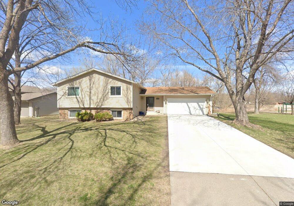
12088 Robin Rd Maple Grove, MN 55369
Estimated Value: $406,000 - $464,000
4
Beds
3
Baths
1,284
Sq Ft
$331/Sq Ft
Est. Value
About This Home
This home is located at 12088 Robin Rd, Maple Grove, MN 55369 and is currently estimated at $425,107, approximately $331 per square foot. 12088 Robin Rd is a home located in Hennepin County with nearby schools including Cedar Island Elementary School, Maple Grove Middle School, and Osseo Senior High School.
Ownership History
Date
Name
Owned For
Owner Type
Purchase Details
Closed on
Apr 24, 2025
Sold by
Lindsay Mark L and Lindsay Christine
Bought by
Lindsay Mark L and Lindsay Christine
Current Estimated Value
Purchase Details
Closed on
Jan 7, 2014
Sold by
Yun Amanda Jung Hee and Lindsay Amanda Jung Hee
Bought by
Lindsay Mark L
Home Financials for this Owner
Home Financials are based on the most recent Mortgage that was taken out on this home.
Original Mortgage
$205,000
Interest Rate
4.42%
Mortgage Type
New Conventional
Purchase Details
Closed on
Jun 25, 2004
Sold by
Bertram Steven M and Bertram Jo E
Bought by
Lindsay Mark L and Lindsay Amanda J
Create a Home Valuation Report for This Property
The Home Valuation Report is an in-depth analysis detailing your home's value as well as a comparison with similar homes in the area
Home Values in the Area
Average Home Value in this Area
Purchase History
| Date | Buyer | Sale Price | Title Company |
|---|---|---|---|
| Lindsay Mark L | $500 | None Listed On Document | |
| Lindsay Mark L | -- | Nations Title Agency Mn Inc | |
| Lindsay Mark L | $247,900 | -- |
Source: Public Records
Mortgage History
| Date | Status | Borrower | Loan Amount |
|---|---|---|---|
| Previous Owner | Lindsay Mark L | $205,000 |
Source: Public Records
Tax History
| Year | Tax Paid | Tax Assessment Tax Assessment Total Assessment is a certain percentage of the fair market value that is determined by local assessors to be the total taxable value of land and additions on the property. | Land | Improvement |
|---|---|---|---|---|
| 2024 | $4,652 | $390,500 | $130,300 | $260,200 |
| 2023 | $4,540 | $388,500 | $121,900 | $266,600 |
| 2022 | $3,683 | $390,900 | $119,000 | $271,900 |
| 2021 | $3,602 | $310,500 | $77,200 | $233,300 |
| 2020 | $3,791 | $298,500 | $77,200 | $221,300 |
| 2019 | $3,693 | $299,900 | $86,300 | $213,600 |
| 2018 | $3,427 | $277,900 | $73,300 | $204,600 |
| 2017 | $3,416 | $245,700 | $67,000 | $178,700 |
| 2016 | $3,533 | $249,800 | $80,000 | $169,800 |
| 2015 | $3,328 | $231,000 | $68,000 | $163,000 |
| 2014 | -- | $219,000 | $70,500 | $148,500 |
Source: Public Records
Map
Nearby Homes
- 6340 Larch Ln N
- 6255 Norwood Ln N
- 12070 Meadowlark Ct
- 6502 Ives Ln N
- 6220 Kirkwood Ln N
- 6686 Ives Ln N
- 6904 Ives Ln N
- 6040 Goldenrod Ln N
- 13445 60th Place N Unit 92
- 6802 Cottonwood Ln N
- 6806 Deerwood Ln N
- 6483 Berkshire Ln N
- 5933 Forestview Ln N
- 11911 71st Ave N
- 5812 Forestview Ln N
- 6826 Berkshire Ln N
- 12060 71st Place N
- 11081 69th Ave N
- 13630 58th Ave N
- 10947 69th Ave N
- 12092 Robin Rd
- 12096 Robin Rd
- 12087 Robin Rd
- 8067 8067 Larch-Lane-
- 8067 8067 Larch-Lane-n
- 8051 8051 Larch-Lane-n
- 12104 Robin Rd
- 12085 Robin Rd
- 12081 Robin Rd
- 12105 Robin Rd
- 12112 Robin Rd
- 6320 Oakview Ln N
- 12109 Robin Rd
- 12118 Robin Rd
- 6331 Oakview Ln N
- 12440 63rd Ave N
- 12460 63rd Ave N
- 12420 63rd Ave N
- 12113 Robin Rd
- 6320 Larch Ln N
Your Personal Tour Guide
Ask me questions while you tour the home.