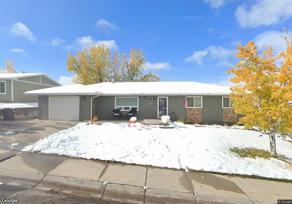
1210 Mcdougall Dr Lander, WY 82520
Estimated Value: $390,000 - $409,000
4
Beds
2
Baths
1,800
Sq Ft
$223/Sq Ft
Est. Value
About This Home
This home is located at 1210 Mcdougall Dr, Lander, WY 82520 and is currently estimated at $401,915, approximately $223 per square foot. 1210 Mcdougall Dr is a home located in Fremont County with nearby schools including Lander Valley High School and Lander Christian Academy.
Ownership History
Date
Name
Owned For
Owner Type
Purchase Details
Closed on
Aug 29, 2012
Sold by
Stores West Inc
Bought by
Meyer Shane and Meyer Alisha
Current Estimated Value
Purchase Details
Closed on
May 22, 2009
Sold by
Larson Alisha M and Meyer Shane M
Bought by
Meyer Shane M and Meyer Alisha M
Purchase Details
Closed on
Mar 21, 2008
Sold by
Gordon Donald A and Gordon Ruth E
Bought by
Larson Alisha M and Meyer Shane M
Home Financials for this Owner
Home Financials are based on the most recent Mortgage that was taken out on this home.
Original Mortgage
$230,000
Interest Rate
5.67%
Mortgage Type
New Conventional
Purchase Details
Closed on
Feb 23, 2007
Sold by
Sawyer Eric S and Sawyer Marit S
Bought by
Gordon Donald A and Gordon Ruth E
Home Financials for this Owner
Home Financials are based on the most recent Mortgage that was taken out on this home.
Original Mortgage
$172,000
Interest Rate
6.25%
Mortgage Type
New Conventional
Create a Home Valuation Report for This Property
The Home Valuation Report is an in-depth analysis detailing your home's value as well as a comparison with similar homes in the area
Home Values in the Area
Average Home Value in this Area
Purchase History
| Date | Buyer | Sale Price | Title Company |
|---|---|---|---|
| Meyer Shane | -- | None Available | |
| Meyer Shane M | -- | Fremont County Title | |
| Larson Alisha M | -- | Fremont County Title | |
| Gordon Donald A | -- | None Available |
Source: Public Records
Mortgage History
| Date | Status | Borrower | Loan Amount |
|---|---|---|---|
| Previous Owner | Larson Alisha M | $230,000 | |
| Previous Owner | Gordon Donald A | $172,000 |
Source: Public Records
Tax History Compared to Growth
Tax History
| Year | Tax Paid | Tax Assessment Tax Assessment Total Assessment is a certain percentage of the fair market value that is determined by local assessors to be the total taxable value of land and additions on the property. | Land | Improvement |
|---|---|---|---|---|
| 2025 | $2,745 | $27,332 | $6,412 | $20,920 |
| 2024 | $2,745 | $35,562 | $8,549 | $27,013 |
| 2023 | $2,624 | $34,265 | $8,289 | $25,976 |
| 2022 | $2,209 | $29,484 | $8,289 | $21,195 |
| 2021 | $1,996 | $25,788 | $8,036 | $17,752 |
| 2020 | $1,935 | $25,050 | $8,036 | $17,014 |
| 2019 | $1,923 | $24,494 | $8,032 | $16,462 |
| 2018 | $1,916 | $24,139 | $8,032 | $16,107 |
| 2017 | $1,840 | $23,129 | $8,032 | $15,097 |
| 2016 | $1,841 | $23,171 | $8,032 | $15,139 |
| 2015 | $1,771 | $22,541 | $8,032 | $14,509 |
| 2014 | $1,716 | $21,876 | $8,032 | $13,844 |
Source: Public Records
Map
Nearby Homes
- 1224 Mcdougall Dr
- 1180 Mcdougall Dr
- 1230 Mcdougall Dr
- 1215 Mcdougall Dr
- 1225 Mcdougall Dr
- 1065 Cascade St
- 1235 Mcdougall Dr
- 1240 Mcdougall Dr
- 1160 Mcdougall Dr
- 1245 Mcdougall Dr
- 1245 Mcdougall Dr Unit S. 9th
- 1245 Mcdougall Dr Unit Cascade
- 789 Welch Blvd
- 789 Welch Blvd Unit cascade
- 791 Welch Blvd
- 793 Welch Blvd
- 1155 Mcdougall Dr
- 1055 Cascade St
- 1255 Mcdougall Dr
- 1255 Mcdougall Dr Unit Smith